
Cycling in Walnut Grove
Discover a map of 419 cycling routes and bike trails near Walnut Grove, created by our community.
Region portrait
Get to know Walnut Grove
Find the right bike route for you through Walnut Grove, where we've got 419 cycle routes to explore. Most people get on their bikes to ride here in the months of July and August.
12,025 km
Tracked distance
419
Cycle routes
25,683
Population

From our community
The best bike routes in and around Walnut Grove

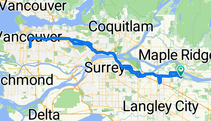
grand langley route
Cycling route in Walnut Grove, British Columbia, Canada
- 56 km
- Distance
- 357 m
- Ascent
- 359 m
- Descent
Watch the ‘Cs’ at the Nat
Cycling route in Walnut Grove, British Columbia, Canada
- 124.6 km
- Distance
- 785 m
- Ascent
- 786 m
- Descent

Ft. Langley to Aldergrove
Cycling route in Walnut Grove, British Columbia, Canada
- 64.3 km
- Distance
- 496 m
- Ascent
- 468 m
- Descent
Fort Langley to Pitt Meadows Loop
Cycling route in Walnut Grove, British Columbia, Canada
- 54 km
- Distance
- 156 m
- Ascent
- 133 m
- Descent
Discover more routes
 Bumpy Distance route
- Distance
- 67.4 km
- Ascent
- 279 m
- Descent
- 280 m
- Location
- Walnut Grove, British Columbia, Canada
 Walnut Grove to Abbotsford and Fort Langley
- Distance
- 57.7 km
- Ascent
- 6,978 m
- Descent
- 6,978 m
- Location
- Walnut Grove, British Columbia, Canada
 Fort Langley to Glenn Valley
- Distance
- 26.7 km
- Ascent
- 123 m
- Descent
- 119 m
- Location
- Walnut Grove, British Columbia, Canada
 Hike Yorkson Dog Park and Willoughby Trail Langley 5 km
- Distance
- 5.3 km
- Ascent
- 27 m
- Descent
- 24 m
- Location
- Walnut Grove, British Columbia, Canada
 fort langley alternate
- Distance
- 49.2 km
- Ascent
- 237 m
- Descent
- 241 m
- Location
- Walnut Grove, British Columbia, Canada
 102KM- summer 2025
- Distance
- 98.6 km
- Ascent
- 918 m
- Descent
- 915 m
- Location
- Walnut Grove, British Columbia, Canada
 22486–22612 88 Ave, Langley to 22011 88 Ave, Langley
- Distance
- 33.9 km
- Ascent
- 23 m
- Descent
- 26 m
- Location
- Walnut Grove, British Columbia, Canada
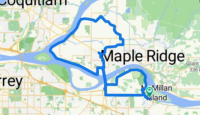
 McMillan Island and Fort to Fort via Allard to 208th 25 KM return
- Distance
- 12.7 km
- Ascent
- 106 m
- Descent
- 108 m
- Location
- Walnut Grove, British Columbia, Canada