
Cycling in Orvieto Scalo
Discover a map of 95 cycling routes and bike trails near Orvieto Scalo, created by our community.
Region portrait
Get to know Orvieto Scalo
Find the right bike route for you through Orvieto Scalo, where we've got 95 cycle routes to explore. Most people get on their bikes to ride here in the months of July and September.
9,006 km
Tracked distance
95
Cycle routes
2,285
Population
Community
Most active users in Orvieto Scalo


From our community
The best bike routes in and around Orvieto Scalo


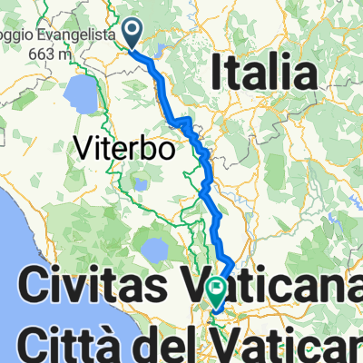
Orvieto Stazione, Orvieto Scalo to Via Giuseppe Mazzini 6, Attigliano
Cycling route in Orvieto Scalo, Umbria, Italy
- 32.8 km
- Distance
- 339 m
- Ascent
- 427 m
- Descent

4B Orvieto - Bagnoregio - Bolsena
Cycling route in Orvieto Scalo, Umbria, Italy
- 33.3 km
- Distance
- 602 m
- Ascent
- 420 m
- Descent

ORVIETO Loop 4 - Corbara (EASY+)
Cycling route in Orvieto Scalo, Umbria, Italy
- 31.9 km
- Distance
- 571 m
- Ascent
- 573 m
- Descent

ORVIETO_CIVITA CASTELLAN
Cycling route in Orvieto Scalo, Umbria, Italy
- 77.4 km
- Distance
- 402 m
- Ascent
- 352 m
- Descent
Discover more routes
 DAY4 ORV-RM 2K18
- Distance
- 134.1 km
- Ascent
- 779 m
- Descent
- 878 m
- Location
- Orvieto Scalo, Umbria, Italy
 D1_F_Orvieto_Bagnoregio
- Distance
- 43 km
- Ascent
- 717 m
- Descent
- 526 m
- Location
- Orvieto Scalo, Umbria, Italy
 ORVIETO 6 (INT+) - Morrano/Corbara
- Distance
- 47.2 km
- Ascent
- 786 m
- Descent
- 788 m
- Location
- Orvieto Scalo, Umbria, Italy
 MONTE AMIATA
- Distance
- 157.3 km
- Ascent
- 2,436 m
- Descent
- 2,432 m
- Location
- Orvieto Scalo, Umbria, Italy
 Bcst13_05da Giove
- Distance
- 34.8 km
- Ascent
- 311 m
- Descent
- 258 m
- Location
- Orvieto Scalo, Umbria, Italy
 4A Orvieto - Montefiascone - Bolsena
- Distance
- 49.8 km
- Ascent
- 650 m
- Descent
- 466 m
- Location
- Orvieto Scalo, Umbria, Italy
 toscana 2007
- Distance
- 190.9 km
- Ascent
- 3,723 m
- Descent
- 3,494 m
- Location
- Orvieto Scalo, Umbria, Italy
 Orvieto Spoleto plus extra via Umbertide and Pesaro
- Distance
- 358.5 km
- Ascent
- 1,918 m
- Descent
- 2,101 m
- Location
- Orvieto Scalo, Umbria, Italy