
Cycling in Heidelberg Heights
Discover a map of 69 cycling routes and bike trails near Heidelberg Heights, created by our community.
Region portrait
Get to know Heidelberg Heights
Find the right bike route for you through Heidelberg Heights, where we've got 69 cycle routes to explore. Most people get on their bikes to ride here in the month of March.
1,337 km
Tracked distance
69
Cycle routes
6,388
Population
Community
Most active users in Heidelberg Heights


From our community
The best bike routes in and around Heidelberg Heights
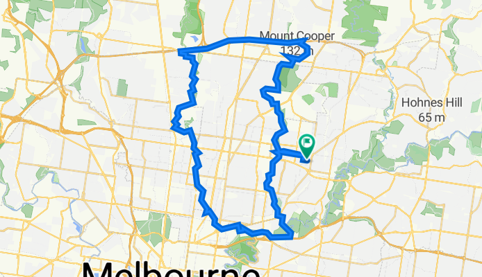
Merri Creek Trail Loop
Cycling route in Heidelberg Heights, Victoria, Australia
- 51.2 km
- Distance
- 286 m
- Ascent
- 288 m
- Descent

Moderate route in
Cycling route in Heidelberg Heights, Victoria, Australia
- 19.3 km
- Distance
- 126 m
- Ascent
- 134 m
- Descent

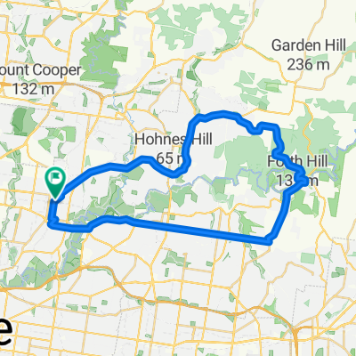
Rosanna / Eltham / Warrandyte Loop
Cycling route in Heidelberg Heights, Victoria, Australia
- 40.5 km
- Distance
- 504 m
- Ascent
- 504 m
- Descent

Hberg route
Cycling route in Heidelberg Heights, Victoria, Australia
- 19.2 km
- Distance
- 129 m
- Ascent
- 129 m
- Descent
Discover more routes
 Work Route
- Distance
- 5.7 km
- Ascent
- 36 m
- Descent
- 19 m
- Location
- Heidelberg Heights, Victoria, Australia
 Southern Road 111, Heidelberg West to Greenbelt Avenue 4, Preston
- Distance
- 9.1 km
- Ascent
- 49 m
- Descent
- 59 m
- Location
- Heidelberg Heights, Victoria, Australia
 Rosanna / Eltham / Warrandyte Loop
- Distance
- 40.5 km
- Ascent
- 356 m
- Descent
- 353 m
- Location
- Heidelberg Heights, Victoria, Australia
 24 Lloyd Street, Heidelberg Heights to 24 Lloyd Street, Heidelberg Heights
- Distance
- 10 km
- Ascent
- 79 m
- Descent
- 78 m
- Location
- Heidelberg Heights, Victoria, Australia
 Rosanna BoxHill
- Distance
- 12.6 km
- Ascent
- 204 m
- Descent
- 204 m
- Location
- Heidelberg Heights, Victoria, Australia
 93–95 Dresden Street, Heidelberg Heights to 24 Lloyd Street, Heidelberg Heights
- Distance
- 8.4 km
- Ascent
- 75 m
- Descent
- 73 m
- Location
- Heidelberg Heights, Victoria, Australia
 34 Wewak Parade, Heidelberg West to 25–35 John Street, Hawthorn
- Distance
- 11.3 km
- Ascent
- 60 m
- Descent
- 80 m
- Location
- Heidelberg Heights, Victoria, Australia
 KInglake Loop and Mt Dandenong Ride
- Distance
- 188 km
- Ascent
- 1,401 m
- Descent
- 1,401 m
- Location
- Heidelberg Heights, Victoria, Australia