How cycling in Taichung could look like.
How cycling in Nantou City could look like.

Cycling day trip from Taichung to Nantou City

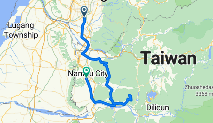
Customize your own route based on our template or discover how our community prefers to cycle from Taichung to Nantou City.

Route template

Taichung to Nantou City

2 h 28 min
Duration
36.5 km
Distance
320 m
Ascent
210 m
Descent
14.8 km/h
Avg. speed
202 m
Max. altitude

Ready for a scenic ride through central Taiwan? This route starts in the lively city of Taichung, famous for its vibrant night markets and laid-back vibes. From there, you’ll roll south toward Nantou City—known as a gateway to Taiwan’s picturesque hill country and tea plantations.

The ~36.5 km journey mostly follows quiet roads (so expect a chill ride), with only a short stretch on busier sections. You'll gain about 320 meters in elevation, so expect a few gentle climbs, but nothing too wild. With just under 40 km ahead, it's a satisfying ride for a morning or afternoon jaunt.

You’ll pedal past a mix of urban outskirts and open countryside, with glimpses of Taiwan’s central mountains on the horizon. Surfaces are mostly paved or asphalt, but some paths are a bit less refined—perfect for mixing up the scenery. Finish up in Nantou City, where you can explore local markets, grab a tea, or plan your next adventure further up into the mountains!

Community

Top users in this region

From our community

The best bike routes from Taichung to Nantou City

0

4月 約騎 - 鳳山寺

Cycling route in Taichung, Taiwan, Taiwan

文心南路 - 63中投 - 縣127 - 台14 - 縣安路 - 148 - 縣137 - 彰82 - 縣139 - 鳳山寺(解散)
40.2 km
Distance
624 m
Ascent
274 m
Descent
12/8明天約騎鳳山寺
Road bikeMTBPaved
張至克
0

12/8明天約騎鳳山寺

Cycling route in Taichung, Taiwan, Taiwan

<span style="font-family: Arial; font-size: x-small;">天氣終於放晴,</span>
34.2 km
Distance
476 m
Ascent
124 m
Descent
微熱山丘爆肺行
Road bikeUnpaved
0

微熱山丘爆肺行

Cycling route in Taichung, Taiwan, Taiwan

海拔很像不高,但是騎起來這么那么累,可能是人的原因,還是這段路真的太陡啦?
36.1 km
Distance
444 m
Ascent
146 m
Descent
台中火車站---&gt;136縣道
Road bikeMTBPaved
0

台中火車站---&gt;136縣道

Cycling route in Taichung, Taiwan, Taiwan

員林搭火車到台中車站--->136一江橋-->赤崁頂-->轉台14-->草屯-->148-->員林-->家 99.8.18實際騎乘  65.39km  爬升956公尺 平均時速19.78km  時間 3:18(不含休息) by Edge705
65.4 km
Distance
890 m
Ascent
933 m
Descent
臺中南屯-東海-彰化139
Road bikeMTBPaved
TPEBikeGo
0

臺中南屯-東海-彰化139

Cycling route in Taichung, Taiwan, Taiwan

59.5 km
Distance
1,023 m
Ascent
694 m
Descent
西屯-鳳山寺-西屯
Road bikePaved
Johnny Hsu
0

西屯-鳳山寺-西屯

Cycling route in Taichung, Taiwan, Taiwan

32.2 km
Distance
585 m
Ascent
268 m
Descent
1

文心星巴克 - 鳳山寺

Cycling route in Taichung, Taiwan, Taiwan

文心星巴克 - 鳳山寺
42.5 km
Distance
607 m
Ascent
281 m
Descent
0

139 Route 明道中學&gt; 禾家牧場&gt;鳳山寺

Cycling route in Taichung, Taiwan, Taiwan

25.1 km
Distance
438 m
Ascent
102 m
Descent
中興大學 --- 鳳山寺.微熱山丘
Road bikeMTBPaved
1

中興大學 --- 鳳山寺.微熱山丘

Cycling route in Taichung, Taiwan, Taiwan

31.5 km
Distance
469 m
Ascent
120 m
Descent
台中-中投-南投
Road bikePaved
Thomas  Hsiao
0

台中-中投-南投

Cycling route in Taichung, Taiwan, Taiwan

29.1 km
Distance
1,142 m
Ascent
1,100 m
Descent
0

柳川東路一段10號, 南區 to 八卦路1310號, 南投市

Cycling route in Taichung, Taiwan, Taiwan

29 km
Distance
436 m
Ascent
94 m
Descent
6

霧峰 TO 微熱山丘

Cycling route in Taichung, Taiwan, Taiwan

19.8 km
Distance
393 m
Ascent
46 m
Descent

Discover more routes