- 50.1 km
- 1,980 m
- 1,355 m
- Maspalomas, Canary Islands, Spain


Cycling day trip from Maspalomas to Mogán
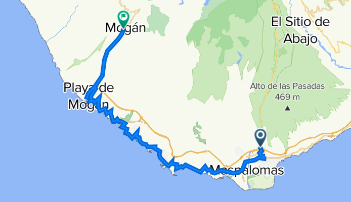
Customize your own route based on our template or discover how our community prefers to cycle from Maspalomas to Mogán.
Route template
Maspalomas to Mogán
From the dunes and lighthouse of Maspalomas, you head inland into classic Gran Canaria terrain—steep barrancos, switchbacks, and palm-filled valleys. It’s a short distance with a big mountain feel: about 48 km with roughly 2,300+ m of climbing, topping out just under 1,000 m. Expect long, steady ascents and punchy ramps, then flowing descents toward Mogán.
The riding is mostly on asphalt and quiet roads, but there are a few rough or gravelly stretches and some busier links—wide tires and good brakes help. Water and shade can be scarce; start early and refill whenever you can (small village cafés are a savior).
Look out for viewpoints over reservoirs like Soria and dramatic ravines carved into the volcanic rock. Maspalomas is famous for its protected sand dunes and 19th‑century Faro de Maspalomas; Mogán, nestled in a fertile valley, is known for its whitewashed houses and fruit orchards. Roll a few extra kilometers down to Puerto de Mogán—“Little Venice”—for a dip and fresh fish by the marina. A tough, memorable day in the island’s sunny southwest.
Bikepacking tours
Already sliced up into perfect stages by our community
- Tour
Community
Top users in this region
From our community
The best bike routes from Maspalomas to Mogán
Avenida Touroperador Ols Wings, San Bartolomé de Tirajana nach Calle Tajinaste, Mogán
Cycling route in Maspalomas, Canary Islands, Spain
- 24.8 km
- Distance
- 643 m
- Ascent
- 485 m
- Descent
Avenida Touroperador Ols Wings, San Bartolomé de Tirajana nach Diseminado Horno Quemados, Mogán
Cycling route in Maspalomas, Canary Islands, Spain
- 21 km
- Distance
- 485 m
- Ascent
- 343 m
- Descent
Avenida Touroperador Ols Wings, San Bartolomé de Tirajana nach GC-604, San Bartolomé de Tirajana
Cycling route in Maspalomas, Canary Islands, Spain
- 19.1 km
- Distance
- 1,067 m
- Ascent
- 395 m
- Descent
Maspalomas - Mogán
Cycling route in Maspalomas, Canary Islands, Spain
- 36.9 km
- Distance
- 0 m
- Ascent
- 0 m
- Descent
Kvänums Patalavaca MTB - Soria
Cycling route in Maspalomas, Canary Islands, Spain
- 50.1 km
- Distance
- 1,980 m
- Ascent
- 1,355 m
- Descent
Circular Chira
Cycling route in Maspalomas, Canary Islands, Spain
- 37.2 km
- Distance
- 1,388 m
- Ascent
- 617 m
- Descent
kanarci 3 dan
Cycling route in Maspalomas, Canary Islands, Spain
- 209.2 km
- Distance
- 4,077 m
- Ascent
- 3,850 m
- Descent
Wyspy Kanaryjskie 2012 - 7.03.2012
Cycling route in Maspalomas, Canary Islands, Spain
- 44.2 km
- Distance
- 473 m
- Ascent
- 510 m
- Descent
maspalomas 20min
Cycling route in Maspalomas, Canary Islands, Spain
- 18.3 km
- Distance
- 977 m
- Ascent
- 203 m
- Descent
Montana del Sandara
Cycling route in Maspalomas, Canary Islands, Spain
- 37.6 km
- Distance
- 1,224 m
- Ascent
- 201 m
- Descent
04_19.03. Maspalomas - Mogan
Cycling route in Maspalomas, Canary Islands, Spain
- 43.6 km
- Distance
- 631 m
- Ascent
- 494 m
- Descent
Discover more routes
- Kvänums Patalavaca MTB - Soria
- Circular Chira
- 37.2 km
- 1,388 m
- 617 m
- Maspalomas, Canary Islands, Spain
- kanarci 3 dan
- 209.2 km
- 4,077 m
- 3,850 m
- Maspalomas, Canary Islands, Spain
- Wyspy Kanaryjskie 2012 - 7.03.2012
- 44.2 km
- 473 m
- 510 m
- Maspalomas, Canary Islands, Spain
- maspalomas 20min
- 18.3 km
- 977 m
- 203 m
- Maspalomas, Canary Islands, Spain
- Montana del Sandara
- 37.6 km
- 1,224 m
- 201 m
- Maspalomas, Canary Islands, Spain
- Maspalomas
- 29.4 km
- 894 m
- 270 m
- Maspalomas, Canary Islands, Spain
- 04_19.03. Maspalomas - Mogan
- 43.6 km
- 631 m
- 494 m
- Maspalomas, Canary Islands, Spain
Routes from Maspalomas
Cycling day trip from
Maspalomas to San Bartolomé de Tirajana
By bicycle from
Maspalomas to Playa del Ingles


