

By bicycle from Maspalomas to Playa del Ingles
Customize your own route based on our template or discover how our community prefers to cycle from Maspalomas to Playa del Ingles.
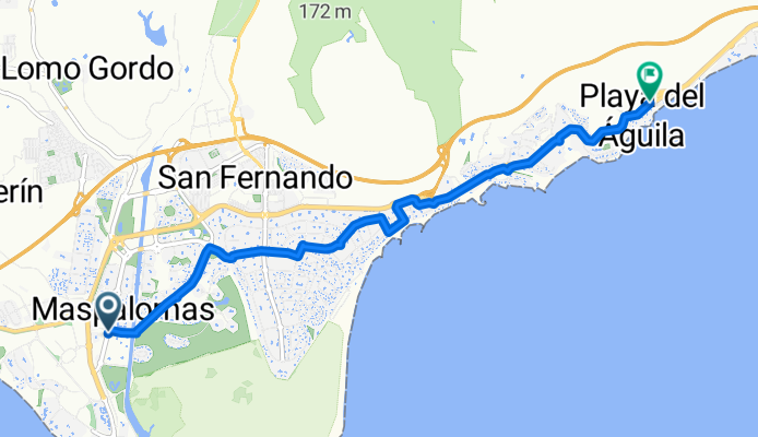
Route template
Maspalomas to Playa del Ingles

- 5 min
- Duration
- 1.5 km
- Distance
- 25 m
- Ascent
- 7 m
- Descent
- 16.9 km/h
- Avg. speed
- 47 m
- Max. altitude
This is a super easy and scenic ride that links two of Gran Canaria’s most famous beach resorts: Maspalomas and Playa del Inglés. You'll be cycling just about 1.5 km, so it’s perfect for a relaxed spin—maybe even in flip-flops!
Starting in Maspalomas, known for its sweeping golden sand dunes and iconic lighthouse, you’ll cruise mostly on quiet roads, glancing over at lush gardens and palm trees. There’s a short, gentle climb (about 25 meters up—no sweat) before you roll down slightly toward Playa del Inglés.
Over 85% of the way is smooth asphalt or paving, so the ride is comfortable, though you’ll pass a tiny stretch less finished—just keep an eye out. Playa del Inglés is super lively, with endless restaurants, bars, and, of course, its beautiful, wide beach. If you fancy, stick around for a swim or an ice cream!
All told, it’s the perfect little coast-hugging hop between two Canary Island highlights.
Bikepacking tours
Already sliced up into perfect stages by our community
 Tour
Tour- Tour
Community
Top users in this region


From our community
The best bike routes from Maspalomas to Playa del Ingles

Calle San José, San Bartolomé de Tirajana nach Calle las Margaritas, San Bartolomé de Tirajana
Cycling route in Maspalomas, Canary Islands, Spain
- 10.6 km
- Distance
- 29 m
- Ascent
- 414 m
- Descent

Calle Doctor Agustín Millares Carló, 18–70, San Bartolomé de Tirajana nach Avenida de Tirajana, 21, San Bartolomé de Tirajana
Cycling route in Maspalomas, Canary Islands, Spain
- 7.2 km
- Distance
- 85 m
- Ascent
- 95 m
- Descent
Avenida Touroperador Tui 21L nach Plaza de los Hibiscus
Cycling route in Maspalomas, Canary Islands, Spain
- 9.4 km
- Distance
- 122 m
- Ascent
- 122 m
- Descent

playa del varil
Cycling route in Maspalomas, Canary Islands, Spain
- 5.5 km
- Distance
- 46 m
- Ascent
- 45 m
- Descent

South coast - Mogan - Anagua - San Bartolomé - Fatata - Maspalomas
Cycling route in Maspalomas, Canary Islands, Spain
- 137 km
- Distance
- 2,964 m
- Ascent
- 2,963 m
- Descent

Grand Canyon XL
Cycling route in Maspalomas, Canary Islands, Spain
- 49.3 km
- Distance
- 917 m
- Ascent
- 974 m
- Descent

Paradise Canyon + citytour
Cycling route in Maspalomas, Canary Islands, Spain
- 28.6 km
- Distance
- 264 m
- Ascent
- 567 m
- Descent

santa Lucia
Cycling route in Maspalomas, Canary Islands, Spain
- 75 km
- Distance
- 1,200 m
- Ascent
- 1,180 m
- Descent

De Avenida de Tejeda 46, San Bartolomé de Tirajana a Calle la Luna 5, San Bartolomé de Tirajana
Cycling route in Maspalomas, Canary Islands, Spain
- 39.3 km
- Distance
- 333 m
- Ascent
- 414 m
- Descent

De GC-503, San Bartolomé de Tirajana a Shopping Centre Nilo, Maspalomas
Cycling route in Maspalomas, Canary Islands, Spain
- 13.9 km
- Distance
- 65 m
- Ascent
- 491 m
- Descent

Etape 4 Ayagaures - Montana La Data
Cycling route in Maspalomas, Canary Islands, Spain
- 36.3 km
- Distance
- 508 m
- Ascent
- 531 m
- Descent

Ho Ho Home in time for tea
Cycling route in Maspalomas, Canary Islands, Spain
- 48.4 km
- Distance
- 1,084 m
- Ascent
- 1,084 m
- Descent
Discover more routes
 South coast - Mogan - Anagua - San Bartolomé - Fatata - Maspalomas
- Distance
- 137 km
- Ascent
- 2,964 m
- Descent
- 2,963 m
- Location
- Maspalomas, Canary Islands, Spain
 Grand Canyon XL
- Distance
- 49.3 km
- Ascent
- 917 m
- Descent
- 974 m
- Location
- Maspalomas, Canary Islands, Spain
 Paradise Canyon + citytour
- Distance
- 28.6 km
- Ascent
- 264 m
- Descent
- 567 m
- Location
- Maspalomas, Canary Islands, Spain
 santa Lucia
- Distance
- 75 km
- Ascent
- 1,200 m
- Descent
- 1,180 m
- Location
- Maspalomas, Canary Islands, Spain
 De Avenida de Tejeda 46, San Bartolomé de Tirajana a Calle la Luna 5, San Bartolomé de Tirajana
- Distance
- 39.3 km
- Ascent
- 333 m
- Descent
- 414 m
- Location
- Maspalomas, Canary Islands, Spain
 De GC-503, San Bartolomé de Tirajana a Shopping Centre Nilo, Maspalomas
- Distance
- 13.9 km
- Ascent
- 65 m
- Descent
- 491 m
- Location
- Maspalomas, Canary Islands, Spain
 Etape 4 Ayagaures - Montana La Data
- Distance
- 36.3 km
- Ascent
- 508 m
- Descent
- 531 m
- Location
- Maspalomas, Canary Islands, Spain
 Ho Ho Home in time for tea
- Distance
- 48.4 km
- Ascent
- 1,084 m
- Descent
- 1,084 m
- Location
- Maspalomas, Canary Islands, Spain