
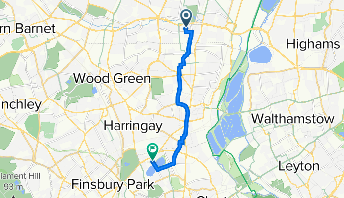
By bicycle from Wood Green to Harringay
Customize your own route based on our template or discover how our community prefers to cycle from Wood Green to Harringay.
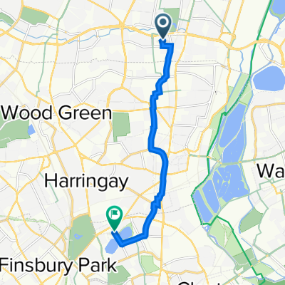
Route template
Wood Green to Harringay

- 14 min
- Duration
- 3.6 km
- Distance
- 0 m
- Ascent
- 17 m
- Descent
- 15.9 km/h
- Avg. speed
- 40 m
- Max. altitude
Set out from lively Wood Green, a bustling North London neighborhood known for its shopping and excellent transport links. This mostly flat, gentle ride takes you south toward Harringay along quiet residential roads and a good stretch of cycleway—ideal for a stress-free spin. You'll enjoy a breezy 3.6 km pedal mostly on paved and asphalt surfaces, weaving past parks and the charming rows of Victorian houses that define this corner of the city.
There’s a slight overall descent, so don’t be surprised if your ride feels easier as you approach Harringay. This area is famous for its diverse food scene and the wildlife-rich New River Path, making it a great place to stop for coffee or a wander after your ride. All in all, a quick, relaxing route perfect for casual cyclists, commuters, or anyone looking to explore two of North London’s friendliest neighborhoods!
Community
Top users in this region


From our community
The best bike routes from Wood Green to Harringay

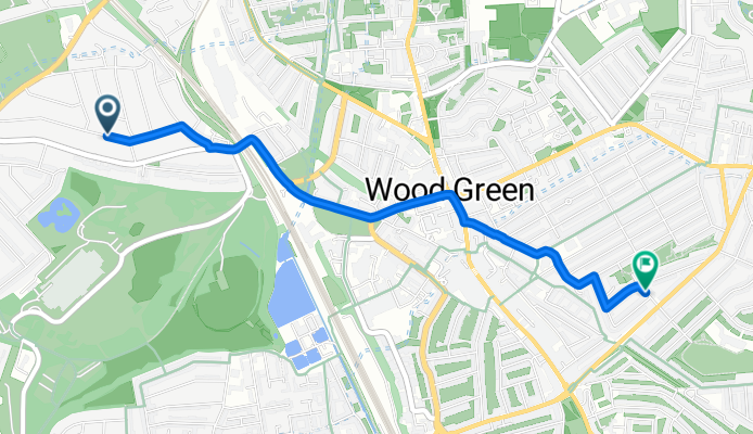
sat 3pm viewber 68 Crowland Road, n15 6uu
Cycling route in Wood Green, England, United Kingdom
- 6.1 km
- Distance
- 16 m
- Ascent
- 58 m
- Descent

parkland walk
Cycling route in Wood Green, England, United Kingdom
- 9.2 km
- Distance
- 128 m
- Ascent
- 124 m
- Descent

Blenheim Mansion, 3 Mary Neuner Road, London to 86 Hewitt Road, London
Cycling route in Wood Green, England, United Kingdom
- 9.4 km
- Distance
- 169 m
- Ascent
- 173 m
- Descent

Martins Walk, London to Mulberry House, 320B High Road, London
Cycling route in Wood Green, England, United Kingdom
- 4.3 km
- Distance
- 33 m
- Ascent
- 42 m
- Descent

20 Morton Way, London to 269-271 Seven Sisters Road, London
Cycling route in Wood Green, England, United Kingdom
- 8.9 km
- Distance
- 82 m
- Ascent
- 87 m
- Descent

9A Queens Parade, Brownlow Road, London to 120 Bank Chambers, High St, London
Cycling route in Wood Green, England, United Kingdom
- 3.3 km
- Distance
- 10 m
- Ascent
- 42 m
- Descent

Enfield, London to Residence Tower, Goodchild Way, Goodchild Road, London
Cycling route in Wood Green, England, United Kingdom
- 6.7 km
- Distance
- 38 m
- Ascent
- 56 m
- Descent
sat Viewber Westbury Avenue
Cycling route in Wood Green, England, United Kingdom
- 3 km
- Distance
- 13 m
- Ascent
- 48 m
- Descent

Redvers Road, London do 216 Green Lanes, London
Cycling route in Wood Green, England, United Kingdom
- 3.8 km
- Distance
- 26 m
- Ascent
- 21 m
- Descent

51.613° N -0.073° W to 51.571° N -0.090° W
Cycling route in Wood Green, England, United Kingdom
- 6.8 km
- Distance
- 41 m
- Ascent
- 23 m
- Descent
North Middlesex Hospital, Sterling Way, London to Residence Tower, Goodchild Way, Goodchild Road, London
Cycling route in Wood Green, England, United Kingdom
- 6.6 km
- Distance
- 36 m
- Ascent
- 23 m
- Descent

North Middlesex Hospital, Sterling Way, London to Waterside Apartments, Goodchild Road, London
Cycling route in Wood Green, England, United Kingdom
- 6.6 km
- Distance
- 39 m
- Ascent
- 26 m
- Descent
Discover more routes
 20 Morton Way, London to 269-271 Seven Sisters Road, London
- Distance
- 8.9 km
- Ascent
- 82 m
- Descent
- 87 m
- Location
- Wood Green, England, United Kingdom
 9A Queens Parade, Brownlow Road, London to 120 Bank Chambers, High St, London
- Distance
- 3.3 km
- Ascent
- 10 m
- Descent
- 42 m
- Location
- Wood Green, England, United Kingdom
 Enfield, London to Residence Tower, Goodchild Way, Goodchild Road, London
- Distance
- 6.7 km
- Ascent
- 38 m
- Descent
- 56 m
- Location
- Wood Green, England, United Kingdom
 sat Viewber Westbury Avenue
- Distance
- 3 km
- Ascent
- 13 m
- Descent
- 48 m
- Location
- Wood Green, England, United Kingdom
 Redvers Road, London do 216 Green Lanes, London
- Distance
- 3.8 km
- Ascent
- 26 m
- Descent
- 21 m
- Location
- Wood Green, England, United Kingdom
 51.613° N -0.073° W to 51.571° N -0.090° W
- Distance
- 6.8 km
- Ascent
- 41 m
- Descent
- 23 m
- Location
- Wood Green, England, United Kingdom
 North Middlesex Hospital, Sterling Way, London to Residence Tower, Goodchild Way, Goodchild Road, London
- Distance
- 6.6 km
- Ascent
- 36 m
- Descent
- 23 m
- Location
- Wood Green, England, United Kingdom
 North Middlesex Hospital, Sterling Way, London to Waterside Apartments, Goodchild Road, London
- Distance
- 6.6 km
- Ascent
- 39 m
- Descent
- 26 m
- Location
- Wood Green, England, United Kingdom
Routes from Wood Green
By bicycle from
Wood Green to Enfield
By bicycle from
Wood Green to Walthamstow
Routes to Harringay
By bicycle from
Walthamstow to Harringay
By bicycle from
Barnsbury to Harringay