
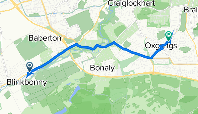
Route template
Currie to Colinton

- 17 min
- Duration
- 4.7 km
- Distance
- 32 m
- Ascent
- 64 m
- Descent
- 16.6 km/h
- Avg. speed
- 148 m
- Max. altitude
This is a lovely and easy cycling ride from Currie to Colinton, taking in some of the leafiest parts of Edinburgh’s southwest. Your journey starts in Currie, a historic village by the Water of Leith with ancient roots stretching back to Roman times. The ride hugs mostly quiet roads and dedicated cycleways, so you’ll get to relax and enjoy the scenery, rather than battle traffic.
You'll roll gently downhill for much of the route (bonus!), dropping around 64 meters in elevation and only climbing about 32, so it's easy on the legs. Most of the surfaces are smooth (asphalt and other pavement), making it a comfy spin even on a standard bike.
You might spot some local wildlife or even glimpses of the historic Colinton Tunnel murals before you finish up in charming Colinton village. Colinton is famous for its connection to poet Robert Louis Stevenson, and its pretty village feel makes for a perfect mid-ride coffee stop or wander along the Water of Leith walkway. All in, it’s a great short ride between two of Edinburgh’s most picturesque suburbs!
Community
Top users in this region


From our community
The best bike routes from Currie to Colinton

343–349 Gyle Ave, Edinburgh to 3 Broomview Path, Edinburgh
Cycling route in Currie, Scotland, United Kingdom
- 3.9 km
- Distance
- 29 m
- Ascent
- 6 m
- Descent

537/1 Lanark Road, Edinburgh to 86–98 Torduff Road, Edinburgh
Cycling route in Currie, Scotland, United Kingdom
- 3.2 km
- Distance
- 56 m
- Ascent
- 29 m
- Descent


57 Lanark Road W, Currie to 20D Oxgangs Ave, Edinburgh
Cycling route in Currie, Scotland, United Kingdom
- 5.7 km
- Distance
- 86 m
- Ascent
- 104 m
- Descent

57 Lanark Road W, Currie to 22D Oxgangs Ave, Edinburgh
Cycling route in Currie, Scotland, United Kingdom
- 5.6 km
- Distance
- 161 m
- Ascent
- 182 m
- Descent

57 Lanark Road W, Currie to 20D Oxgangs Ave, Edinburgh
Cycling route in Currie, Scotland, United Kingdom
- 6.6 km
- Distance
- 666 m
- Ascent
- 545 m
- Descent

57 Lanark Road W, Currie to 22D Oxgangs Ave, Edinburgh
Cycling route in Currie, Scotland, United Kingdom
- 5.7 km
- Distance
- 83 m
- Ascent
- 105 m
- Descent

57 Lanark Road W, Currie to 22D Oxgangs Ave, Edinburgh
Cycling route in Currie, Scotland, United Kingdom
- 7.3 km
- Distance
- 594 m
- Ascent
- 470 m
- Descent

49–51 Lanark Road W, Currie to 22D Oxgangs Ave, Edinburgh
Cycling route in Currie, Scotland, United Kingdom
- 8.6 km
- Distance
- 1,707 m
- Ascent
- 1,589 m
- Descent
49–51 Lanark Road W, Currie to 20D Oxgangs Ave, Edinburgh
Cycling route in Currie, Scotland, United Kingdom
- 6.6 km
- Distance
- 998 m
- Ascent
- 879 m
- Descent

49–51 Lanark Road W, Currie to 22D Oxgangs Ave, Edinburgh
Cycling route in Currie, Scotland, United Kingdom
- 6.6 km
- Distance
- 913 m
- Ascent
- 789 m
- Descent

Calder Gardens 18 to Barn Park 29
Cycling route in Currie, Scotland, United Kingdom
- 2.6 km
- Distance
- 34 m
- Ascent
- 35 m
- Descent
Discover more routes
 57 Lanark Road W, Currie to 22D Oxgangs Ave, Edinburgh
- Distance
- 5.6 km
- Ascent
- 161 m
- Descent
- 182 m
- Location
- Currie, Scotland, United Kingdom
 57 Lanark Road W, Currie to 20D Oxgangs Ave, Edinburgh
- Distance
- 6.6 km
- Ascent
- 666 m
- Descent
- 545 m
- Location
- Currie, Scotland, United Kingdom
 57 Lanark Road W, Currie to 22D Oxgangs Ave, Edinburgh
- Distance
- 5.7 km
- Ascent
- 83 m
- Descent
- 105 m
- Location
- Currie, Scotland, United Kingdom
 57 Lanark Road W, Currie to 22D Oxgangs Ave, Edinburgh
- Distance
- 7.3 km
- Ascent
- 594 m
- Descent
- 470 m
- Location
- Currie, Scotland, United Kingdom
 49–51 Lanark Road W, Currie to 22D Oxgangs Ave, Edinburgh
- Distance
- 8.6 km
- Ascent
- 1,707 m
- Descent
- 1,589 m
- Location
- Currie, Scotland, United Kingdom
 49–51 Lanark Road W, Currie to 20D Oxgangs Ave, Edinburgh
- Distance
- 6.6 km
- Ascent
- 998 m
- Descent
- 879 m
- Location
- Currie, Scotland, United Kingdom
 49–51 Lanark Road W, Currie to 22D Oxgangs Ave, Edinburgh
- Distance
- 6.6 km
- Ascent
- 913 m
- Descent
- 789 m
- Location
- Currie, Scotland, United Kingdom
 Calder Gardens 18 to Barn Park 29
- Distance
- 2.6 km
- Ascent
- 34 m
- Descent
- 35 m
- Location
- Currie, Scotland, United Kingdom
Routes to Colinton
Quick ride by bicycle from
Edinburgh to Colinton