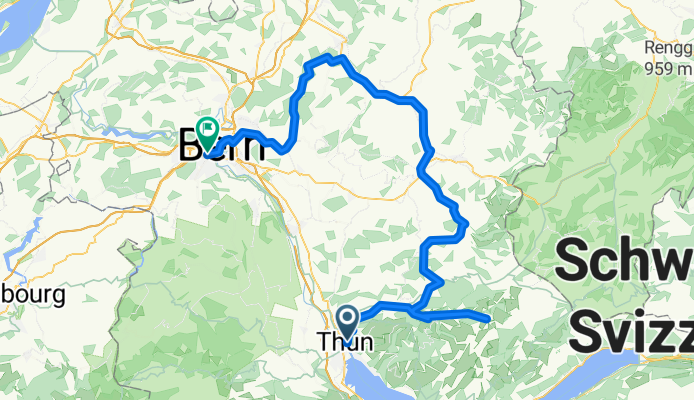
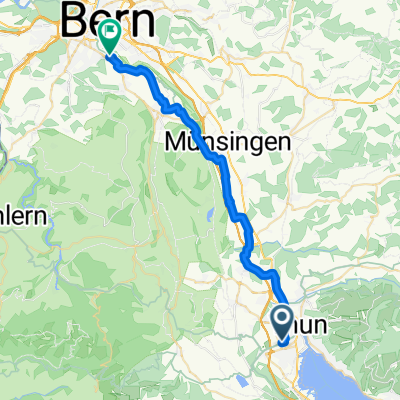
Route template
Thun to Bern

- 2 h 6 min
- Duration
- 34.1 km
- Distance
- 210 m
- Ascent
- 223 m
- Descent
- 16.3 km/h
- Avg. speed
- 592 m
- Max. altitude
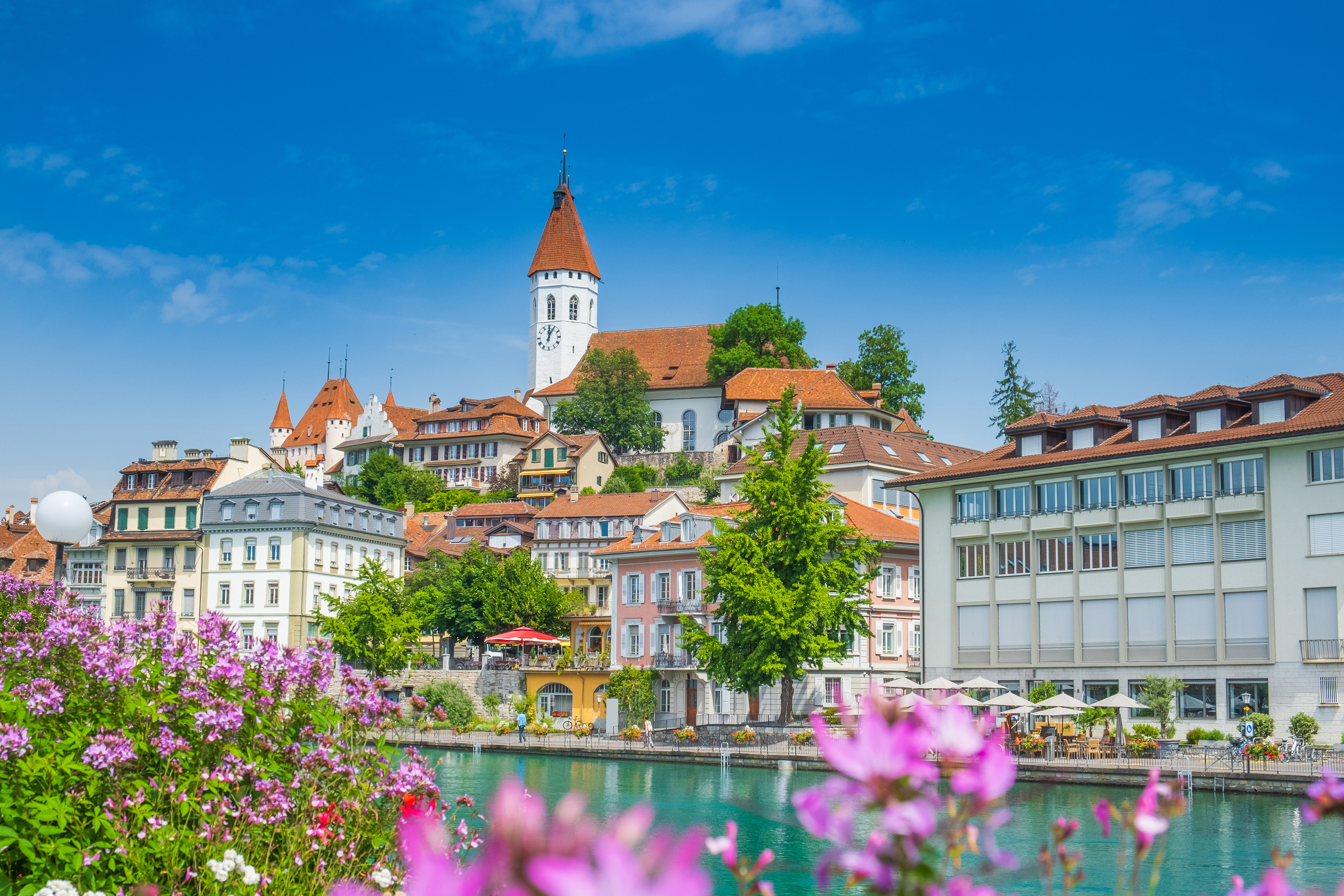
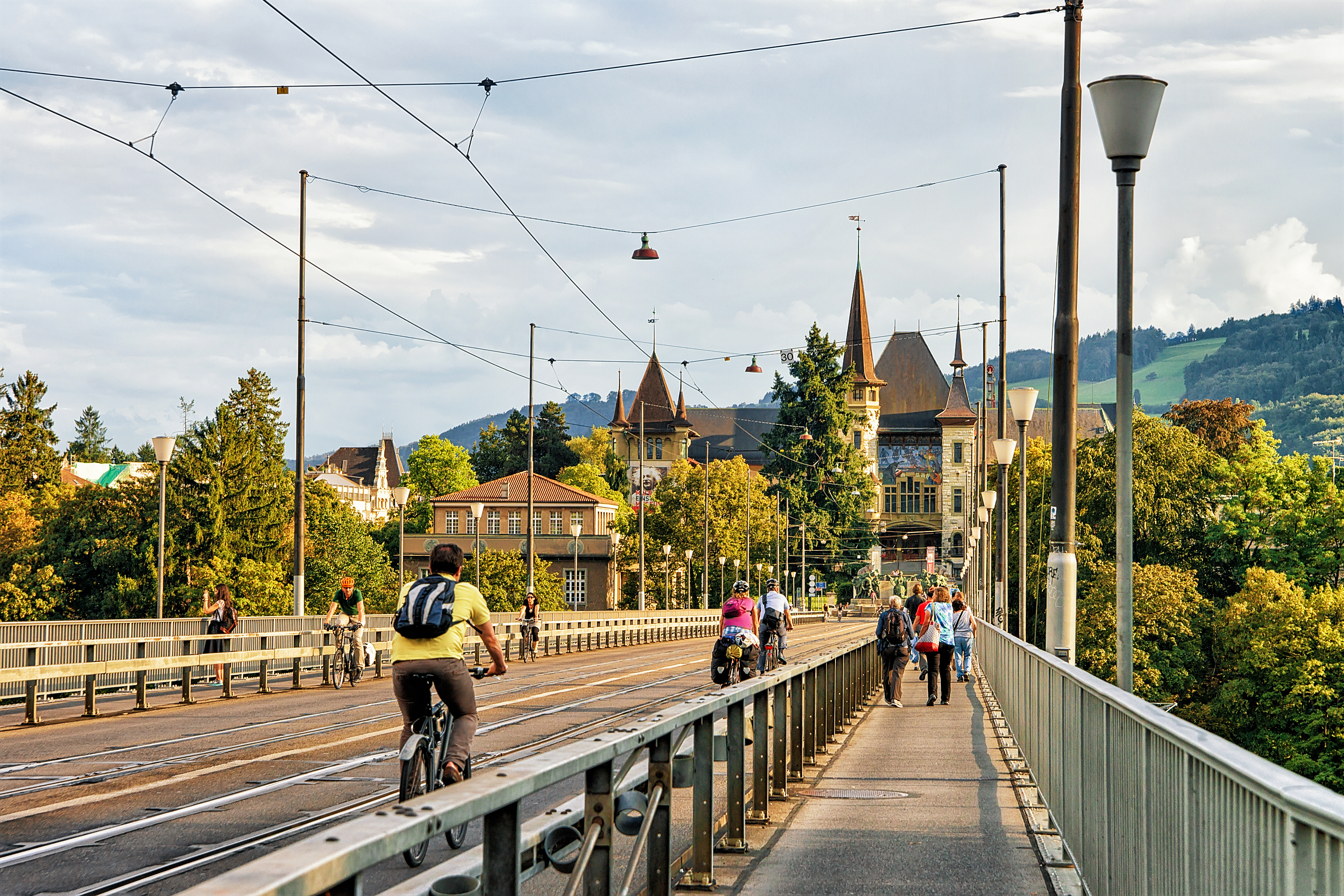
Looking for a scenic and relaxed ride from Thun to Bern? This cycle route is just over 34 km and takes you through some lovely Swiss countryside. You’ll start in the historic town of Thun, perched at the edge of Lake Thun with its fairytale castle and views of the Alps. From here, you’ll pedal northwest toward Bern, a UNESCO-listed capital with a charming old town, riverside promenades, and those iconic cobbled streets.
The route is a mix of quiet roads and cycleways, with most of the surface paved or asphalt, making it smooth and comfortable for most bikes. There are a few gentle climbs (just over 200m ascent) and descents, but nothing too tough—perfect for stretching your legs and soaking up the views. Expect a bit of gravel and unpaved track, so sturdy tires are a plus.
It’s a great way to experience the transition from lakeside beauty to Bern’s historical heart. Don’t forget to treat yourself to a coffee or gelato in Bern’s old town as a reward for your ride!
Community
Top users in this region


From our community
The best bike routes from Thun to Bern

Thun - Schwarzenburg - Bern
Cycling route in Thun, Canton of Bern, Switzerland
- 52.4 km
- Distance
- 597 m
- Ascent
- 611 m
- Descent

Thun - Bern über Mamishaus - Hinter-/Vorderfultigen - Zimmerwald - Köniz
Cycling route in Thun, Canton of Bern, Switzerland
- 62.3 km
- Distance
- 771 m
- Ascent
- 797 m
- Descent

ERiztal ab thun
Cycling route in Thun, Canton of Bern, Switzerland
- 78.1 km
- Distance
- 951 m
- Ascent
- 976 m
- Descent

HIN SEV Bern
Cycling route in Thun, Canton of Bern, Switzerland
- 31.8 km
- Distance
- 110 m
- Ascent
- 153 m
- Descent

Niesenblickstrasse, Thun nach Eichholz, Wabern
Cycling route in Thun, Canton of Bern, Switzerland
- 30.2 km
- Distance
- 127 m
- Ascent
- 142 m
- Descent
Thun quer durchs emmental nach bern
Cycling route in Thun, Canton of Bern, Switzerland
- 103.5 km
- Distance
- 671 m
- Ascent
- 710 m
- Descent

C60+ Thun-Zwieselberg-Bern
Cycling route in Thun, Canton of Bern, Switzerland
- 55.8 km
- Distance
- 548 m
- Ascent
- 559 m
- Descent

Gwattstrasse 103, Gwatt (Thun) to Aarweg, Berne
Cycling route in Thun, Canton of Bern, Switzerland
- 34.4 km
- Distance
- 659 m
- Ascent
- 717 m
- Descent

Thun Gurnigel Salzmatt Bern
Cycling route in Thun, Canton of Bern, Switzerland
- 119.3 km
- Distance
- 2,401 m
- Ascent
- 2,423 m
- Descent

Swisstopo Route
Cycling route in Thun, Canton of Bern, Switzerland
- 33.6 km
- Distance
- 168 m
- Ascent
- 168 m
- Descent

Alpenstrasse 11, Thun nach Schwanengasse 10, Bern
Cycling route in Thun, Canton of Bern, Switzerland
- 33.8 km
- Distance
- 293 m
- Ascent
- 345 m
- Descent

Thun-Sigriswil-Beatenberg-Interlaken-Mülenen-Wimmis-Amsoldingen-Gürbetal-Bern
Cycling route in Thun, Canton of Bern, Switzerland
- 108.6 km
- Distance
- 1,147 m
- Ascent
- 1,179 m
- Descent
Discover more routes
 Niesenblickstrasse, Thun nach Eichholz, Wabern
- Distance
- 30.2 km
- Ascent
- 127 m
- Descent
- 142 m
- Location
- Thun, Canton of Bern, Switzerland
 Thun quer durchs emmental nach bern
- Distance
- 103.5 km
- Ascent
- 671 m
- Descent
- 710 m
- Location
- Thun, Canton of Bern, Switzerland
 C60+ Thun-Zwieselberg-Bern
- Distance
- 55.8 km
- Ascent
- 548 m
- Descent
- 559 m
- Location
- Thun, Canton of Bern, Switzerland
 Gwattstrasse 103, Gwatt (Thun) to Aarweg, Berne
- Distance
- 34.4 km
- Ascent
- 659 m
- Descent
- 717 m
- Location
- Thun, Canton of Bern, Switzerland
 Thun Gurnigel Salzmatt Bern
- Distance
- 119.3 km
- Ascent
- 2,401 m
- Descent
- 2,423 m
- Location
- Thun, Canton of Bern, Switzerland
 Swisstopo Route
- Distance
- 33.6 km
- Ascent
- 168 m
- Descent
- 168 m
- Location
- Thun, Canton of Bern, Switzerland
 Alpenstrasse 11, Thun nach Schwanengasse 10, Bern
- Distance
- 33.8 km
- Ascent
- 293 m
- Descent
- 345 m
- Location
- Thun, Canton of Bern, Switzerland
 Thun-Sigriswil-Beatenberg-Interlaken-Mülenen-Wimmis-Amsoldingen-Gürbetal-Bern
- Distance
- 108.6 km
- Ascent
- 1,147 m
- Descent
- 1,179 m
- Location
- Thun, Canton of Bern, Switzerland
Routes to Bern
Cycling day trip from
Fribourg to Bern
Cycling day trip from
Biel/Bienne to Bern
By bicycle from
Zollikofen to Bern
By bicycle from
Muri bei Bern to Bern