
Cycling day trip from Silvaplana to Zernez
Customize your own route based on our template or discover how our community prefers to cycle from Silvaplana to Zernez.
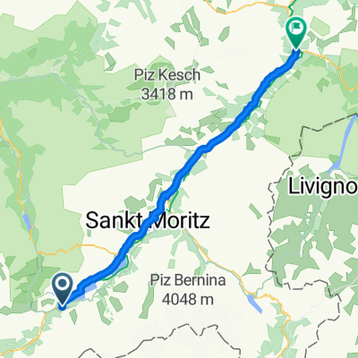
Route template
Silvaplana to Zernez

- 3 h 24 min
- Duration
- 46 km
- Distance
- 857 m
- Ascent
- 1,196 m
- Descent
- 13.5 km/h
- Avg. speed
- 1,887 m
- Max. altitude
Ready for a scenic ride through the heart of the Engadin? This route takes you from the sparkling shores of Silvaplana Lake up and over to the beautiful village of Zernez—a journey of about 46 km that will get your heart pumping and eyes feasting on views.
Starting in Silvaplana, famous for its winds that attract windsurfers from all over, you’ll cruise past towering peaks and deep, lush forests. The ride is a mixture of paved and gravel roads, with a good chunk of the route (about half!) on gentle tracks and quiet roads, making it perfect for anyone who loves peaceful pedaling with a little adventure thrown in.
There’s some climbing (just under 900 meters up!) but even more exhilarating descents on the way to Zernez. And when you arrive, you’re in a gateway village to the Swiss National Park—a perfect spot to refuel and explore if you still have energy. Don’t forget to stop for some photos: this is Swiss Alps cycling at its finest!
Community
Top users in this region


From our community
The best bike routes from Silvaplana to Zernez

Maloja - Lavin
Cycling route in Silvaplana, Grisons, Switzerland
- 66.8 km
- Distance
- 181 m
- Ascent
- 578 m
- Descent

Innská-1.den
Cycling route in Silvaplana, Grisons, Switzerland
- 65 km
- Distance
- 251 m
- Ascent
- 636 m
- Descent

Maloja-Zernes
Cycling route in Silvaplana, Grisons, Switzerland
- 57.9 km
- Distance
- 142 m
- Ascent
- 472 m
- Descent

Innradweg_Tag 1
Cycling route in Silvaplana, Grisons, Switzerland
- 54.7 km
- Distance
- 227 m
- Ascent
- 574 m
- Descent

Innradweg © Meister-Jango Tag 1 Maloja nach Zernez 54,74 km
Cycling route in Silvaplana, Grisons, Switzerland
- 54.7 km
- Distance
- 277 m
- Ascent
- 625 m
- Descent

IR_1_Maloja_Zernez_hg
Cycling route in Silvaplana, Grisons, Switzerland
- 55.1 km
- Distance
- 568 m
- Ascent
- 907 m
- Descent

Innradweg Maloja Etappe 1 Entwurf 2
Cycling route in Silvaplana, Grisons, Switzerland
- 56.7 km
- Distance
- 568 m
- Ascent
- 900 m
- Descent

Maloja - Zernez
Cycling route in Silvaplana, Grisons, Switzerland
- 52.7 km
- Distance
- 236 m
- Ascent
- 557 m
- Descent

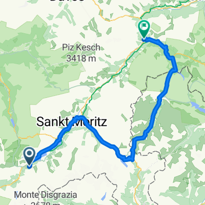
Maloja - Bernina pass - Livigno - Zernez
Cycling route in Silvaplana, Grisons, Switzerland
- 88.5 km
- Distance
- 1,247 m
- Ascent
- 1,595 m
- Descent

Maloja-Moritz-Zernez
Cycling route in Silvaplana, Grisons, Switzerland
- 49.9 km
- Distance
- 150 m
- Ascent
- 496 m
- Descent


2017-07-14 Passo del Bernina (2.328 m) - Forcola di Livigno (2.315 m)
Cycling route in Silvaplana, Grisons, Switzerland
- 91.4 km
- Distance
- 1,372 m
- Ascent
- 1,682 m
- Descent
Discover more routes
 Innradweg © Meister-Jango Tag 1 Maloja nach Zernez 54,74 km
- Distance
- 54.7 km
- Ascent
- 277 m
- Descent
- 625 m
- Location
- Silvaplana, Grisons, Switzerland
 IR_1_Maloja_Zernez_hg
- Distance
- 55.1 km
- Ascent
- 568 m
- Descent
- 907 m
- Location
- Silvaplana, Grisons, Switzerland
 Innradweg Maloja Etappe 1 Entwurf 2
- Distance
- 56.7 km
- Ascent
- 568 m
- Descent
- 900 m
- Location
- Silvaplana, Grisons, Switzerland
 Maloja - Zernez
- Distance
- 52.7 km
- Ascent
- 236 m
- Descent
- 557 m
- Location
- Silvaplana, Grisons, Switzerland
 Maloja - Bernina pass - Livigno - Zernez
- Distance
- 88.5 km
- Ascent
- 1,247 m
- Descent
- 1,595 m
- Location
- Silvaplana, Grisons, Switzerland
 Maloja-Moritz-Zernez
- Distance
- 49.9 km
- Ascent
- 150 m
- Descent
- 496 m
- Location
- Silvaplana, Grisons, Switzerland
 Maloja Zernez
- Distance
- 60 km
- Ascent
- 251 m
- Descent
- 591 m
- Location
- Silvaplana, Grisons, Switzerland
 2017-07-14 Passo del Bernina (2.328 m) - Forcola di Livigno (2.315 m)
- Distance
- 91.4 km
- Ascent
- 1,372 m
- Descent
- 1,682 m
- Location
- Silvaplana, Grisons, Switzerland
Routes to Zernez
Cycling day trip from
Scuol to Zernez
Cycling day trip from
Davos to Zernez