
Cycling day trip from Kreuzlingen to Stein am Rhein
Customize your own route based on our template or discover how our community prefers to cycle from Kreuzlingen to Stein am Rhein.
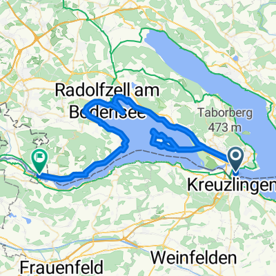
Route template
Kreuzlingen to Stein am Rhein

- 1 h 40 min
- Duration
- 29.9 km
- Distance
- 371 m
- Ascent
- 384 m
- Descent
- 18 km/h
- Avg. speed
- 474 m
- Max. altitude
Set off from Kreuzlingen, hugging the Swiss shore of Lake Constance—this town is known for its relaxed lakeside vibe and as a gateway to Germany, with the city of Konstanz sitting just across the border. Your ride rolls west, taking you mostly along quiet roads and some gentle tracks, perfect for a leisurely pace with minimal traffic stress.
The route is just under 30 km with a few rolling hills for fun, accumulating about 370 meters of ascent, so expect a mild workout with scenic lake views and glimpses of the rolling Thurgau countryside. It’s almost entirely paved, so road bikes are ideal, and you’ll pass through idyllic Swiss villages along the way—perfect for a coffee stop.
Your destination is Stein am Rhein, a storybook medieval town where the Rhine River leaves Lake Constance. It’s famous for its impeccably preserved historic center, frescoed buildings, and charming riverfront. Park the bike, stroll the cobblestone streets, and soak up the fairy-tale atmosphere before heading back or hopping on a train home.
Community
Top users in this region


From our community
The best bike routes from Kreuzlingen to Stein am Rhein

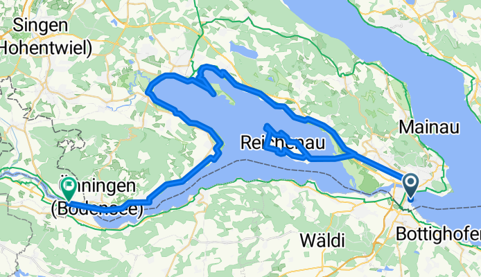
D 251 Konstanz - Stein am Rhein
Cycling route in Kreuzlingen, Thurgau, Switzerland
- 29.5 km
- Distance
- 75 m
- Ascent
- 75 m
- Descent

Bodensee negyedik nap megtett út
Cycling route in Kreuzlingen, Thurgau, Switzerland
- 59.8 km
- Distance
- 125 m
- Ascent
- 124 m
- Descent

Kreuzlingen - Stein am Rhein
Cycling route in Kreuzlingen, Thurgau, Switzerland
- 29.2 km
- Distance
- 118 m
- Ascent
- 126 m
- Descent

Bodensee_3 Konstanz - Stein am Rhein
Cycling route in Kreuzlingen, Thurgau, Switzerland
- 63.5 km
- Distance
- 91 m
- Ascent
- 95 m
- Descent
Konstanz to Rathausplatz: Thursday
Cycling route in Kreuzlingen, Thurgau, Switzerland
- 66.3 km
- Distance
- 213 m
- Ascent
- 210 m
- Descent

BS Tag 4 (5) Konstanz Stein a Rhein
Cycling route in Kreuzlingen, Thurgau, Switzerland
- 65.7 km
- Distance
- 139 m
- Ascent
- 142 m
- Descent

Rheinextreme 1. Etappe - Alternative
Cycling route in Kreuzlingen, Thurgau, Switzerland
- 245.6 km
- Distance
- 344 m
- Ascent
- 337 m
- Descent

Münzgasse 23, Konstanz nach Rhigass 5, Stein am Rhein
Cycling route in Kreuzlingen, Thurgau, Switzerland
- 29 km
- Distance
- 246 m
- Ascent
- 259 m
- Descent

Day 1 Konstanz to Stein am Rhein
Cycling route in Kreuzlingen, Thurgau, Switzerland
- 31.2 km
- Distance
- 56 m
- Ascent
- 60 m
- Descent


Münzgasse 23, Konstanz nach Rhigass 5, Stein am Rhein
Cycling route in Kreuzlingen, Thurgau, Switzerland
- 28.6 km
- Distance
- 68 m
- Ascent
- 73 m
- Descent

Bahnhofstrasse 14, Kreuzlingen nach Bahnhofstrasse 13, Stein am Rhein
Cycling route in Kreuzlingen, Thurgau, Switzerland
- 28.8 km
- Distance
- 272 m
- Ascent
- 263 m
- Descent
Discover more routes
 Konstanz to Rathausplatz: Thursday
- Distance
- 66.3 km
- Ascent
- 213 m
- Descent
- 210 m
- Location
- Kreuzlingen, Thurgau, Switzerland
 BS Tag 4 (5) Konstanz Stein a Rhein
- Distance
- 65.7 km
- Ascent
- 139 m
- Descent
- 142 m
- Location
- Kreuzlingen, Thurgau, Switzerland
 Rheinextreme 1. Etappe - Alternative
- Distance
- 245.6 km
- Ascent
- 344 m
- Descent
- 337 m
- Location
- Kreuzlingen, Thurgau, Switzerland
 Münzgasse 23, Konstanz nach Rhigass 5, Stein am Rhein
- Distance
- 29 km
- Ascent
- 246 m
- Descent
- 259 m
- Location
- Kreuzlingen, Thurgau, Switzerland
 Day 1 Konstanz to Stein am Rhein
- Distance
- 31.2 km
- Ascent
- 56 m
- Descent
- 60 m
- Location
- Kreuzlingen, Thurgau, Switzerland
 Etappe 03
- Distance
- 29.5 km
- Ascent
- 64 m
- Descent
- 51 m
- Location
- Kreuzlingen, Thurgau, Switzerland
 Münzgasse 23, Konstanz nach Rhigass 5, Stein am Rhein
- Distance
- 28.6 km
- Ascent
- 68 m
- Descent
- 73 m
- Location
- Kreuzlingen, Thurgau, Switzerland
 Bahnhofstrasse 14, Kreuzlingen nach Bahnhofstrasse 13, Stein am Rhein
- Distance
- 28.8 km
- Ascent
- 272 m
- Descent
- 263 m
- Location
- Kreuzlingen, Thurgau, Switzerland
Routes from Kreuzlingen
Cycling day trip from
Kreuzlingen to Radolfzell
Cycling day trip from
Kreuzlingen to Überlingen
Quick ride by bicycle from
Kreuzlingen to Tägerwilen
Quick ride by bicycle from
Kreuzlingen to Konstanz
Routes to Stein am Rhein
Cycling day trip from
Konstanz to Stein am Rhein
Cycling day trip from
Radolfzell to Stein am Rhein