
Cycling day trip from Winklern to Heiligenblut am Großglockner
Customize your own route based on our template or discover how our community prefers to cycle from Winklern to Heiligenblut am Großglockner.
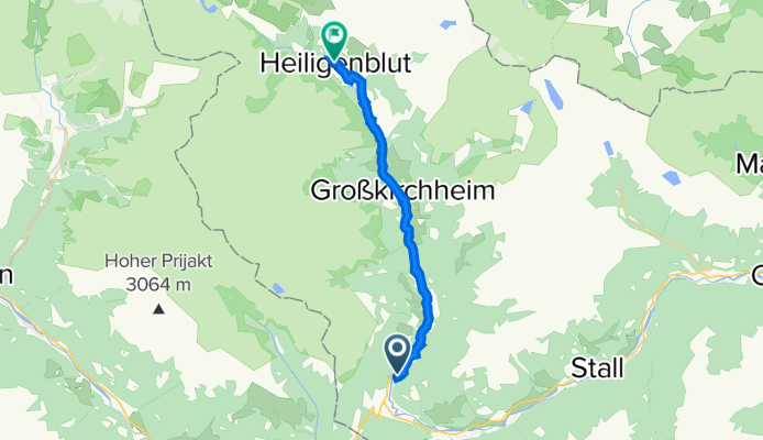
Route template
Winklern to Heiligenblut am Großglockner

- 3 h 5 min
- Duration
- 26.4 km
- Distance
- 1,272 m
- Ascent
- 985 m
- Descent
- 8.6 km/h
- Avg. speed
- 1,543 m
- Max. altitude
Looking for a challenging and scenic ride in the Austrian Alps? Set off from Winklern, a charming village nestled in the Mölltal valley, and pedal your way north to the legendary mountain village of Heiligenblut am Großglockner. This 26-kilometer route packs in over 1,200 meters of climbing—get ready for some serious elevation gain!
The ride will take you along a diverse mix of quiet roads, tracks, and paths, with half the route on paved surfaces, but expect a fair amount of gravel and even some sections with a missing surface—so a gravel or mountain bike is ideal. The scenery is jaw-dropping throughout, especially as you approach Heiligenblut, famous for its dramatic church spire and as the gateway to the Grossglockner High Alpine Road, Austria’s highest mountain pass.
Take your time to soak in the alpine vistas and, if you have a bit of energy left, wander through Heiligenblut’s picturesque streets—legend has it the church houses a vial of Christ’s blood! This ride is tough, but the reward at the end is more than worth it.
Community
Top users in this region


From our community
The best bike routes from Winklern to Heiligenblut am Großglockner

3 - Winklern - Heiligenblut
Cycling route in Winklern, Carinthia, Austria
- 25 km
- Distance
- 607 m
- Ascent
- 190 m
- Descent

RR-Berg: Grossglockner KURZ (Winklern-Heiligenblut-Hochtor-Edelweissspitze)
Cycling route in Winklern, Carinthia, Austria
- 45.3 km
- Distance
- 1,992 m
- Ascent
- 370 m
- Descent
Mi10 Winklern - Heiligenblut 22+22 330HM
Cycling route in Winklern, Carinthia, Austria
- 21.6 km
- Distance
- 566 m
- Ascent
- 149 m
- Descent

E3 Alternative: Winklern - Edelweißspitze am Großglockner
Cycling route in Winklern, Carinthia, Austria
- 43.4 km
- Distance
- 1,998 m
- Ascent
- 377 m
- Descent

Etap 4 ( alternatywa ) Winklem - czoło lodowca.
Cycling route in Winklern, Carinthia, Austria
- 37.5 km
- Distance
- 1,512 m
- Ascent
- 120 m
- Descent

Hochtor von Winklern aus
Cycling route in Winklern, Carinthia, Austria
- 36.8 km
- Distance
- 1,720 m
- Ascent
- 123 m
- Descent

Winklern - Franz-Josefs-Höhe
Cycling route in Winklern, Carinthia, Austria
- 38.7 km
- Distance
- 1,543 m
- Ascent
- 120 m
- Descent

Winklern - Heiligenblut
Cycling route in Winklern, Carinthia, Austria
- 25.5 km
- Distance
- 522 m
- Ascent
- 100 m
- Descent


Winklern - Hochtor
Cycling route in Winklern, Carinthia, Austria
- 36.9 km
- Distance
- 1,686 m
- Ascent
- 114 m
- Descent

Winklern Edelweißspitze
Cycling route in Winklern, Carinthia, Austria
- 46.4 km
- Distance
- 2,075 m
- Ascent
- 447 m
- Descent
Discover more routes
 Etap 4 ( alternatywa ) Winklem - czoło lodowca.
- Distance
- 37.5 km
- Ascent
- 1,512 m
- Descent
- 120 m
- Location
- Winklern, Carinthia, Austria
 Hochtor von Winklern aus
- Distance
- 36.8 km
- Ascent
- 1,720 m
- Descent
- 123 m
- Location
- Winklern, Carinthia, Austria
 Winklern - Franz-Josefs-Höhe
- Distance
- 38.7 km
- Ascent
- 1,543 m
- Descent
- 120 m
- Location
- Winklern, Carinthia, Austria
 Winklern - Heiligenblut
- Distance
- 25.5 km
- Ascent
- 522 m
- Descent
- 100 m
- Location
- Winklern, Carinthia, Austria
 grossglokner
- Distance
- 35.6 km
- Ascent
- 1,898 m
- Descent
- 234 m
- Location
- Winklern, Carinthia, Austria
 Großglockner
- Distance
- 42.3 km
- Ascent
- 1,886 m
- Descent
- 452 m
- Location
- Winklern, Carinthia, Austria
 Winklern - Hochtor
- Distance
- 36.9 km
- Ascent
- 1,686 m
- Descent
- 114 m
- Location
- Winklern, Carinthia, Austria
 Winklern Edelweißspitze
- Distance
- 46.4 km
- Ascent
- 2,075 m
- Descent
- 447 m
- Location
- Winklern, Carinthia, Austria
Routes to Heiligenblut am Großglockner
Cycling day trip from
Zell am See to Heiligenblut am Großglockner
Cycling day trip from
Lienz to Heiligenblut am Großglockner
Quick ride by bicycle from
Großkirchheim to Heiligenblut am Großglockner