

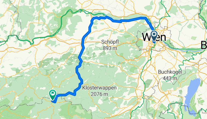
Route template
Vienna to Mariazell

- 10 h 22 min
- Duration
- 173.3 km
- Distance
- 2,140 m
- Ascent
- 1,476 m
- Descent
- 16.7 km/h
- Avg. speed
- 1,016 m
- Max. altitude
Ready for a grand ride? This route takes you from the heart of Vienna, Austria’s elegant capital full of imperial history, all the way to the charming town of Mariazell, one of the country’s most beloved pilgrimage destinations.
It’s about 173 km, so plan for a long day (or two!) in the saddle. You’ll start on Vienna’s urban bike paths, quickly slipping into quieter country roads. The ride weaves through scenic Austrian countryside, featuring rolling hills, lush forests, and serene villages. About 79% of the surfaces are paved (mostly smooth asphalt), but do watch for some stretches with unknown conditions—so pack a repair kit, just in case!
This isn’t a flat route: expect over 2,000 meters of climbing, with the highest point topping 1,000 meters. Your reward? Epic views and that satisfying descent as Mariazell’s famous basilica and mountain scenery comes into view.
Start with a Viennese coffee, end with traditional gingerbread in Mariazell—this ride is a true taste of Austria on two wheels!
Bikepacking tours
Already sliced up into perfect stages by our community
Community
Top users in this region


From our community
The best bike routes from Vienna to Mariazell

Wien - Mariazell (und retour)
Cycling route in Vienna, Vienna, Austria
- 163.2 km
- Distance
- 970 m
- Ascent
- 373 m
- Descent

Tour de Barcelona 2014 dzień 6
Cycling route in Vienna, Vienna, Austria
- 133.4 km
- Distance
- 1,304 m
- Ascent
- 719 m
- Descent


Wien - Mariazell
Cycling route in Vienna, Vienna, Austria
- 154 km
- Distance
- 1,837 m
- Ascent
- 1,146 m
- Descent

Nach Mariazell
Cycling route in Vienna, Vienna, Austria
- 133.5 km
- Distance
- 1,667 m
- Ascent
- 1,079 m
- Descent

Wien (16) - Mariazell
Cycling route in Vienna, Vienna, Austria
- 125.4 km
- Distance
- 1,464 m
- Ascent
- 832 m
- Descent

Wien - Annaberg - Mariazell
Cycling route in Vienna, Vienna, Austria
- 134.7 km
- Distance
- 1,524 m
- Ascent
- 865 m
- Descent

ottakring-mariazell -- dritte variante 16.08.2014
Cycling route in Vienna, Vienna, Austria
- 141.7 km
- Distance
- 1,823 m
- Ascent
- 1,195 m
- Descent

Wien Mariazell Direktroute mit Höhenmetern
Cycling route in Vienna, Vienna, Austria
- 142.2 km
- Distance
- 1,857 m
- Ascent
- 1,161 m
- Descent

Betriebsausfahrt
Cycling route in Vienna, Vienna, Austria
- 137.3 km
- Distance
- 1,806 m
- Ascent
- 1,156 m
- Descent

Schönbrunn - Mariazell
Cycling route in Vienna, Vienna, Austria
- 151.2 km
- Distance
- 1,738 m
- Ascent
- 1,097 m
- Descent
Discover more routes
 Nach Mariazell
- Distance
- 133.5 km
- Ascent
- 1,667 m
- Descent
- 1,079 m
- Location
- Vienna, Vienna, Austria
 Wien (16) - Mariazell
- Distance
- 125.4 km
- Ascent
- 1,464 m
- Descent
- 832 m
- Location
- Vienna, Vienna, Austria
 Wien - Annaberg - Mariazell
- Distance
- 134.7 km
- Ascent
- 1,524 m
- Descent
- 865 m
- Location
- Vienna, Vienna, Austria
 ottakring-mariazell -- dritte variante 16.08.2014
- Distance
- 141.7 km
- Ascent
- 1,823 m
- Descent
- 1,195 m
- Location
- Vienna, Vienna, Austria
 Wien Mariazell Direktroute mit Höhenmetern
- Distance
- 142.2 km
- Ascent
- 1,857 m
- Descent
- 1,161 m
- Location
- Vienna, Vienna, Austria
 Betriebsausfahrt
- Distance
- 137.3 km
- Ascent
- 1,806 m
- Descent
- 1,156 m
- Location
- Vienna, Vienna, Austria
 Marizell
- Distance
- 167.9 km
- Ascent
- 881 m
- Descent
- 226 m
- Location
- Vienna, Vienna, Austria
 Schönbrunn - Mariazell
- Distance
- 151.2 km
- Ascent
- 1,738 m
- Descent
- 1,097 m
- Location
- Vienna, Vienna, Austria
Routes from Vienna
Bikepacking from
Vienna to Budapest
Bikepacking from
Vienna to Brno
Cycling day trip from
Vienna to Mödling
Cycling day trip from
Vienna to Mauerbach
Quick ride by bicycle from
Vienna to Leopoldsdorf
Quick ride by bicycle from
Vienna to Bisamberg
Routes to Mariazell
Cycling day trip from
Sankt Pölten to Mariazell