

By bicycle from Gerasdorf bei Wien to Vienna
Customize your own route based on our template or discover how our community prefers to cycle from Gerasdorf bei Wien to Vienna.
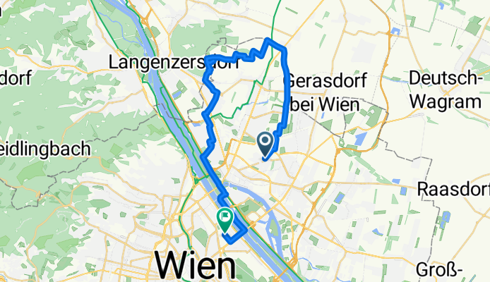
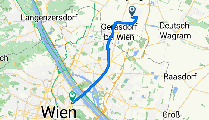
Route template
Gerasdorf bei Wien to Vienna

- 1 h 1 min
- Duration
- 17.1 km
- Distance
- 111 m
- Ascent
- 76 m
- Descent
- 16.8 km/h
- Avg. speed
- 193 m
- Max. altitude
Looking for an easy ride from the edge of Vienna into the city? Start your journey in Gerasdorf bei Wien—a quiet town just north of Vienna known for its friendly local vibe and suburban scenery. This 17-kilometer route takes you mostly along paved or asphalt cycleways (so no need to worry about tricky surfaces), and you’ll enjoy a relaxing ride with gentle ups and downs, perfect for most cyclists.
The first part of the ride zips through peaceful neighborhoods and farmland, and as you get closer to Vienna, you’ll notice the vibe shift to more urban surroundings. With nearly 70% of the route on dedicated cycle paths and most of the rest on quiet roads, you can focus on the sights instead of traffic stress.
You’ll finish right in Vienna—Austria’s grand capital, famous for its coffee culture, imperial palaces, and vibrant city life. So whether you’re commuting or just exploring, this route is a smooth and scenic way to roll into one of Europe’s great cities!
Community
Top users in this region


From our community
The best bike routes from Gerasdorf bei Wien to Vienna


Afterwork River Ride 231123
Cycling route in Gerasdorf bei Wien, Lower Austria, Austria
- 21.1 km
- Distance
- 45 m
- Ascent
- 52 m
- Descent

Maurichgasse - Kratochwjlestraße (Verkehrsroute)
Cycling route in Gerasdorf bei Wien, Lower Austria, Austria
- 2.5 km
- Distance
- 15 m
- Ascent
- 12 m
- Descent


Urban Afterwork with sundowner
Cycling route in Gerasdorf bei Wien, Lower Austria, Austria
- 31.9 km
- Distance
- 169 m
- Ascent
- 174 m
- Descent


Bisamberg Gravel über Magdalenenhof und Donauinsel
Cycling route in Gerasdorf bei Wien, Lower Austria, Austria
- 27.8 km
- Distance
- 235 m
- Ascent
- 242 m
- Descent


foody gravel ride: Donaublick & GraggerChorherr 110524
Cycling route in Gerasdorf bei Wien, Lower Austria, Austria
- 49.8 km
- Distance
- 321 m
- Ascent
- 339 m
- Descent


Friday water cruising, the spring edition Vienna
Cycling route in Gerasdorf bei Wien, Lower Austria, Austria
- 29.4 km
- Distance
- 125 m
- Ascent
- 161 m
- Descent


Sunday coffee cruisen. Herbst edition.
Cycling route in Gerasdorf bei Wien, Lower Austria, Austria
- 18.7 km
- Distance
- 132 m
- Ascent
- 182 m
- Descent

Floridsdorf - Kahlenberg - Am Himmel - Währing
Cycling route in Gerasdorf bei Wien, Lower Austria, Austria
- 24.5 km
- Distance
- 385 m
- Ascent
- 332 m
- Descent

Marchfeldkanal , Hubertusdamm
Cycling route in Gerasdorf bei Wien, Lower Austria, Austria
- 61.5 km
- Distance
- 42 m
- Ascent
- 45 m
- Descent

zur Donauinsel
Cycling route in Gerasdorf bei Wien, Lower Austria, Austria
- 6.7 km
- Distance
- 40 m
- Ascent
- 37 m
- Descent


Westgasse, Герасдорф до Lassallestraße, Вена
Cycling route in Gerasdorf bei Wien, Lower Austria, Austria
- 16.4 km
- Distance
- 103 m
- Ascent
- 111 m
- Descent

10) 2006: Stamm- Neusiedlersee- Ungarn- Stamm
Cycling route in Gerasdorf bei Wien, Lower Austria, Austria
- 241.4 km
- Distance
- 623 m
- Ascent
- 624 m
- Descent
Discover more routes
 foody gravel ride: Donaublick & GraggerChorherr 110524
- Distance
- 49.8 km
- Ascent
- 321 m
- Descent
- 339 m
- Location
- Gerasdorf bei Wien, Lower Austria, Austria
 Friday water cruising, the spring edition Vienna
- Distance
- 29.4 km
- Ascent
- 125 m
- Descent
- 161 m
- Location
- Gerasdorf bei Wien, Lower Austria, Austria
 Sunday coffee cruisen. Herbst edition.
- Distance
- 18.7 km
- Ascent
- 132 m
- Descent
- 182 m
- Location
- Gerasdorf bei Wien, Lower Austria, Austria
 Floridsdorf - Kahlenberg - Am Himmel - Währing
- Distance
- 24.5 km
- Ascent
- 385 m
- Descent
- 332 m
- Location
- Gerasdorf bei Wien, Lower Austria, Austria
 Marchfeldkanal , Hubertusdamm
- Distance
- 61.5 km
- Ascent
- 42 m
- Descent
- 45 m
- Location
- Gerasdorf bei Wien, Lower Austria, Austria
 zur Donauinsel
- Distance
- 6.7 km
- Ascent
- 40 m
- Descent
- 37 m
- Location
- Gerasdorf bei Wien, Lower Austria, Austria
 Westgasse, Герасдорф до Lassallestraße, Вена
- Distance
- 16.4 km
- Ascent
- 103 m
- Descent
- 111 m
- Location
- Gerasdorf bei Wien, Lower Austria, Austria
 10) 2006: Stamm- Neusiedlersee- Ungarn- Stamm
- Distance
- 241.4 km
- Ascent
- 623 m
- Descent
- 624 m
- Location
- Gerasdorf bei Wien, Lower Austria, Austria
Routes from Gerasdorf bei Wien
Cycling day trip from
Gerasdorf bei Wien to Schwechat
Cycling day trip from
Gerasdorf bei Wien to Bratislava
By bicycle from
Gerasdorf bei Wien to Langenzersdorf
Routes to Vienna
Bikepacking from
Budapest to Vienna
Bikepacking from
Brno to Vienna
Cycling day trip from
Baden to Vienna
Cycling day trip from
Atzenbrugg to Vienna
By bicycle from
Groß-Enzersdorf to Vienna
By bicycle from
Schwechat to Vienna