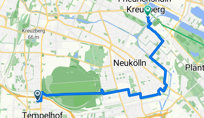

Route template
Tempelhof to Treptow
This fun Berlin cycling route takes you from Tempelhof to Treptow—two very intriguing districts! You’ll cover just under 9 km, almost entirely on smooth surfaces (asphalt and paving stones mostly), so you can leave your chunky tires at home.
Starting in Tempelhof, famed for its massive decommissioned airport-turned-park (Tempelhofer Feld), you’ll enjoy broad streets and bike-friendly paths. After weaving through some quieter residential roads and leafy paths (about a third of the way is on official cycleways), the ride gently meanders north and east.
Expect a mostly flat journey with just a tiny bit of ascent and descent—hardly noticeable. As you cross into Treptow, the vibe shifts: keep an eye out for riverside views, huge parks (like the beautiful Treptower Park), and some cool Soviet-era monuments. Most of your trip is traffic-calmed or away from cars, making it great for a stress-free cruise.
In short: Tempelhof’s urban openness meets Treptow’s green allure in one chilled-out cycling route!
Community
Top users in this region
From our community
The best bike routes from Tempelhof to Treptow
Neukölln Runde
Cycling route in Tempelhof, State of Berlin, Germany
- 10.5 km
- Distance
- 57 m
- Ascent
- 56 m
- Descent
Wannse Track
Cycling route in Tempelhof, State of Berlin, Germany
- 93.4 km
- Distance
- 120 m
- Ascent
- 121 m
- Descent
Die Neukölln-Kreuzberg-Caputh-Fresdorf-Runde
Cycling route in Tempelhof, State of Berlin, Germany
- 108.3 km
- Distance
- 219 m
- Ascent
- 219 m
- Descent
Borussiastraße, Berlin nach Wrangelstraße, Berlin
Cycling route in Tempelhof, State of Berlin, Germany
- 10.4 km
- Distance
- 119 m
- Ascent
- 132 m
- Descent
Neukölln, Berlin nach Paul-Lincke-Ufer, Berlin
Cycling route in Tempelhof, State of Berlin, Germany
- 3.9 km
- Distance
- 29 m
- Ascent
- 43 m
- Descent
A100, Berlin to Forster Straße, Berlin
Cycling route in Tempelhof, State of Berlin, Germany
- 7 km
- Distance
- 18 m
- Ascent
- 30 m
- Descent
Emser Straße 65, Berlin to Donaustraße 114, Berlin
Cycling route in Tempelhof, State of Berlin, Germany
- 2.9 km
- Distance
- 10 m
- Ascent
- 29 m
- Descent
Oderstraße 22, Berlin nach Paul-Lincke-Ufer 23, Berlin
Cycling route in Tempelhof, State of Berlin, Germany
- 8.8 km
- Distance
- 133 m
- Ascent
- 158 m
- Descent
Tempelhof-Schöneberg, Berlin nach Kienitzer Straße, Berlin
Cycling route in Tempelhof, State of Berlin, Germany
- 3.9 km
- Distance
- 13 m
- Ascent
- 16 m
- Descent
Friedrich-Wilhelm-Straße, Berlin nach Wiener Straße, Berlin
Cycling route in Tempelhof, State of Berlin, Germany
- 7.8 km
- Distance
- 22 m
- Ascent
- 35 m
- Descent
Silbersteinstraße 54, Berlin nach Paul-Lincke-Ufer 23, Berlin
Cycling route in Tempelhof, State of Berlin, Germany
- 5.3 km
- Distance
- 4 m
- Ascent
- 20 m
- Descent
Volkmarstraße, Berlin to Wiener Straße, Berlin
Cycling route in Tempelhof, State of Berlin, Germany
- 7.5 km
- Distance
- 26 m
- Ascent
- 32 m
- Descent
Discover more routes
- Neukölln, Berlin nach Paul-Lincke-Ufer, Berlin
- Distance
- 3.9 km
- Ascent
- 29 m
- Descent
- 43 m
- Location
- Tempelhof, State of Berlin, Germany
- A100, Berlin to Forster Straße, Berlin
- Distance
- 7 km
- Ascent
- 18 m
- Descent
- 30 m
- Location
- Tempelhof, State of Berlin, Germany
- Emser Straße 65, Berlin to Donaustraße 114, Berlin
- Distance
- 2.9 km
- Ascent
- 10 m
- Descent
- 29 m
- Location
- Tempelhof, State of Berlin, Germany
- Oderstraße 22, Berlin nach Paul-Lincke-Ufer 23, Berlin
- Distance
- 8.8 km
- Ascent
- 133 m
- Descent
- 158 m
- Location
- Tempelhof, State of Berlin, Germany
- Tempelhof-Schöneberg, Berlin nach Kienitzer Straße, Berlin
- Distance
- 3.9 km
- Ascent
- 13 m
- Descent
- 16 m
- Location
- Tempelhof, State of Berlin, Germany
- Friedrich-Wilhelm-Straße, Berlin nach Wiener Straße, Berlin
- Distance
- 7.8 km
- Ascent
- 22 m
- Descent
- 35 m
- Location
- Tempelhof, State of Berlin, Germany
- Silbersteinstraße 54, Berlin nach Paul-Lincke-Ufer 23, Berlin
- Distance
- 5.3 km
- Ascent
- 4 m
- Descent
- 20 m
- Location
- Tempelhof, State of Berlin, Germany
- Volkmarstraße, Berlin to Wiener Straße, Berlin
- Distance
- 7.5 km
- Ascent
- 26 m
- Descent
- 32 m
- Location
- Tempelhof, State of Berlin, Germany
Routes from Tempelhof
Quick ride by bicycle from
Tempelhof to Mariendorf
Quick ride by bicycle from
Tempelhof to Berlin Schöneberg
Routes to Treptow
Quick ride by bicycle from
Berlin to Treptow
Quick ride by bicycle from
Friedrichshain to Treptow