
Quick ride by bicycle from Pankow to Reinickendorf
Customize your own route based on our template or discover how our community prefers to cycle from Pankow to Reinickendorf.
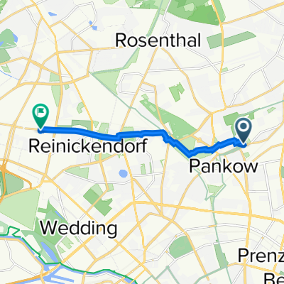
Route template
Pankow to Reinickendorf

- 58 min
- Duration
- 12.6 km
- Distance
- 15 m
- Ascent
- 21 m
- Descent
- 12.9 km/h
- Avg. speed
- 49 m
- Max. altitude
This relaxed cycling route takes you from Pankow to Reinickendorf, two northern boroughs of Berlin known for their laid-back, green character. Starting in Pankow, you’ll pedal through a mostly paved route—expect lots of smooth asphalt and only short sections of cobblestone and paving stones. The ride is mostly flat, with very gentle up- and downhills, making it beginner-friendly and great for city bikes.
Almost half your journey runs along quiet roads, with a good portion on dedicated paths and cycleways. You’ll pass through peaceful residential neighborhoods and leafy streets, catching glimpses of local parks and allotment gardens that are typical of this part of Berlin. No need to worry about busy traffic—busy roads are pretty much absent along this route.
Reinickendorf, your destination, is a district that blends old Berlin charm with plenty of green spaces and lakes. Take a breather when you arrive and enjoy a stroll in one of its parks or head to nearby Tegeler See if you’re up for a little extra adventure!
Community
Top users in this region


From our community
The best bike routes from Pankow to Reinickendorf

Bürgerstraße 17, Berlin nach Reinickendorf, Berlin
Cycling route in Pankow, State of Berlin, Germany
- 2.1 km
- Distance
- 0 m
- Ascent
- 0 m
- Descent

Berliner Straße 101, Berlin nach Müllerstraße 70, Berlin
Cycling route in Pankow, State of Berlin, Germany
- 6 km
- Distance
- 6 m
- Ascent
- 18 m
- Descent

Kavalierstraße 2, Berlin to Waldstraße 87, Berlin
Cycling route in Pankow, State of Berlin, Germany
- 6.6 km
- Distance
- 6 m
- Ascent
- 12 m
- Descent

Kavalierstraße 5, Berlin to Waldstraße 14, Berlin
Cycling route in Pankow, State of Berlin, Germany
- 6.6 km
- Distance
- 6 m
- Ascent
- 16 m
- Descent

Wolfshagener Straße 70–74, Berlin to Waldstraße 87, Berlin
Cycling route in Pankow, State of Berlin, Germany
- 6.5 km
- Distance
- 6 m
- Ascent
- 19 m
- Descent

Elisabethweg 11, Berlin nach Gotthardstraße 62, Berlin
Cycling route in Pankow, State of Berlin, Germany
- 5.3 km
- Distance
- 6 m
- Ascent
- 10 m
- Descent

52.572° N 13.412° W to 52.575° N 13.326° W
Cycling route in Pankow, State of Berlin, Germany
- 6.7 km
- Distance
- 3 m
- Ascent
- 10 m
- Descent

Kavalierstraße 4, Berlin to Waldstraße 87, Berlin
Cycling route in Pankow, State of Berlin, Germany
- 6.6 km
- Distance
- 3 m
- Ascent
- 10 m
- Descent

Kavalierstraße 2, Berlin to Waldstraße 12A, Berlin
Cycling route in Pankow, State of Berlin, Germany
- 6.5 km
- Distance
- 3 m
- Ascent
- 10 m
- Descent

52.572° N 13.412° W to 52.576° N 13.326° W
Cycling route in Pankow, State of Berlin, Germany
- 6.6 km
- Distance
- 3 m
- Ascent
- 10 m
- Descent

Kavalierstraße 4, Berlin to Waldstraße 86, Berlin
Cycling route in Pankow, State of Berlin, Germany
- 6.6 km
- Distance
- 3 m
- Ascent
- 11 m
- Descent

Steegerstraße 72, Berlin nach Flottenstraße 1, Berlin
Cycling route in Pankow, State of Berlin, Germany
- 4.6 km
- Distance
- 4 m
- Ascent
- 7 m
- Descent
Discover more routes
 Wolfshagener Straße 70–74, Berlin to Waldstraße 87, Berlin
- Distance
- 6.5 km
- Ascent
- 6 m
- Descent
- 19 m
- Location
- Pankow, State of Berlin, Germany
 Elisabethweg 11, Berlin nach Gotthardstraße 62, Berlin
- Distance
- 5.3 km
- Ascent
- 6 m
- Descent
- 10 m
- Location
- Pankow, State of Berlin, Germany
 52.572° N 13.412° W to 52.575° N 13.326° W
- Distance
- 6.7 km
- Ascent
- 3 m
- Descent
- 10 m
- Location
- Pankow, State of Berlin, Germany
 Kavalierstraße 4, Berlin to Waldstraße 87, Berlin
- Distance
- 6.6 km
- Ascent
- 3 m
- Descent
- 10 m
- Location
- Pankow, State of Berlin, Germany
 Kavalierstraße 2, Berlin to Waldstraße 12A, Berlin
- Distance
- 6.5 km
- Ascent
- 3 m
- Descent
- 10 m
- Location
- Pankow, State of Berlin, Germany
 52.572° N 13.412° W to 52.576° N 13.326° W
- Distance
- 6.6 km
- Ascent
- 3 m
- Descent
- 10 m
- Location
- Pankow, State of Berlin, Germany
 Kavalierstraße 4, Berlin to Waldstraße 86, Berlin
- Distance
- 6.6 km
- Ascent
- 3 m
- Descent
- 11 m
- Location
- Pankow, State of Berlin, Germany
 Steegerstraße 72, Berlin nach Flottenstraße 1, Berlin
- Distance
- 4.6 km
- Ascent
- 4 m
- Descent
- 7 m
- Location
- Pankow, State of Berlin, Germany
Routes from Pankow
Quick ride by bicycle from
Pankow to Gesundbrunnen
Quick ride by bicycle from
Pankow to Wittenau