
By bicycle from Opladen to Leverkusen
Customize your own route based on our template or discover how our community prefers to cycle from Opladen to Leverkusen.
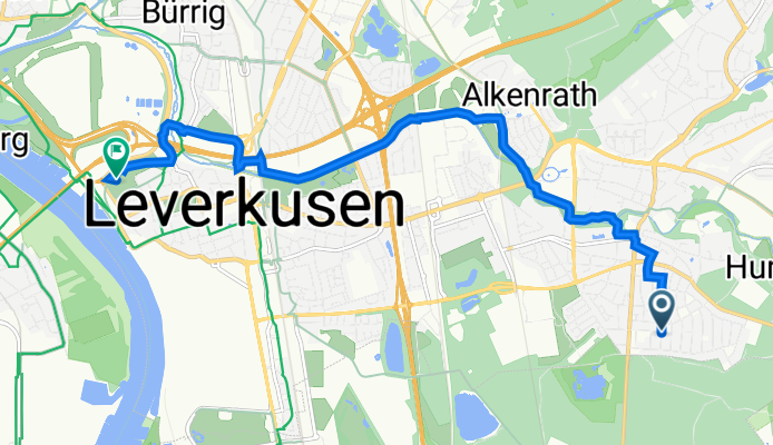
Route template
Opladen to Leverkusen

- 23 min
- Duration
- 6.6 km
- Distance
- 6 m
- Ascent
- 17 m
- Descent
- 17.4 km/h
- Avg. speed
- 65 m
- Max. altitude
This easy ride takes you from Opladen to the heart of Leverkusen, covering just under 7 kilometers along mostly quiet, paved roads. Opladen, a lively district known for its charming old town and rail history, is a great spot to start. As you head south, you’ll enjoy a laid-back route—mostly smooth asphalt, minimal hills, so it’s a breeze for any level of cyclist.
The route winds through peaceful local streets, with a short section on a dedicated cycleway and barely any busy roads, making for a relaxed journey. You’ll roll past green strips and residential areas before reaching Leverkusen, famous for its ties to the Bayer pharmaceutical company and its Bundesliga football club.
With gentle elevation and plenty of scenic spots for a quick break, this ride is perfect if you want to stretch your legs or commute between the two neighborhoods. Wrap up your trip with a visit to Leverkusen’s city center or take a stroll along the nearby Rhine!
Community
Top users in this region


From our community
The best bike routes from Opladen to Leverkusen

Elbsee - Naturschutzgebiet Unterbach
Cycling route in Opladen, North Rhine-Westphalia, Germany
- 61.8 km
- Distance
- 120 m
- Ascent
- 130 m
- Descent

Dhünntalsperre (zur Überarbeitung)
Cycling route in Opladen, North Rhine-Westphalia, Germany
- 61.5 km
- Distance
- 657 m
- Ascent
- 643 m
- Descent
Dillinger Straße 5, Leverkusen nach Westring 3, Leverkusen
Cycling route in Opladen, North Rhine-Westphalia, Germany
- 8.9 km
- Distance
- 39 m
- Ascent
- 47 m
- Descent

Kerschensteinerstraße 13, Leverkusen nach Wiesdorfer Platz 48, Leverkusen
Cycling route in Opladen, North Rhine-Westphalia, Germany
- 3.1 km
- Distance
- 7 m
- Ascent
- 11 m
- Descent
20170524_165752.gpx
Cycling route in Opladen, North Rhine-Westphalia, Germany
- 2.3 km
- Distance
- 0 m
- Ascent
- 16 m
- Descent

20160830_155402.gpx
Cycling route in Opladen, North Rhine-Westphalia, Germany
- 2.1 km
- Distance
- 0 m
- Ascent
- 16 m
- Descent

20160715_143916.gpx
Cycling route in Opladen, North Rhine-Westphalia, Germany
- 2.4 km
- Distance
- 0 m
- Ascent
- 16 m
- Descent

Kerschensteinerstraße 13, Leverkusen nach Rheinallee 3, Leverkusen
Cycling route in Opladen, North Rhine-Westphalia, Germany
- 4.5 km
- Distance
- 3 m
- Ascent
- 19 m
- Descent

Arbeit 1
Cycling route in Opladen, North Rhine-Westphalia, Germany
- 7.6 km
- Distance
- 26 m
- Ascent
- 82 m
- Descent

20160902_145630.gpx
Cycling route in Opladen, North Rhine-Westphalia, Germany
- 2.5 km
- Distance
- 0 m
- Ascent
- 18 m
- Descent

20160906_164809.gpx
Cycling route in Opladen, North Rhine-Westphalia, Germany
- 2.4 km
- Distance
- 0 m
- Ascent
- 17 m
- Descent

20160905_155808.gpx
Cycling route in Opladen, North Rhine-Westphalia, Germany
- 2.4 km
- Distance
- 0 m
- Ascent
- 16 m
- Descent
Discover more routes
 20170524_165752.gpx
- Distance
- 2.3 km
- Ascent
- 0 m
- Descent
- 16 m
- Location
- Opladen, North Rhine-Westphalia, Germany
 20160830_155402.gpx
- Distance
- 2.1 km
- Ascent
- 0 m
- Descent
- 16 m
- Location
- Opladen, North Rhine-Westphalia, Germany
 20160715_143916.gpx
- Distance
- 2.4 km
- Ascent
- 0 m
- Descent
- 16 m
- Location
- Opladen, North Rhine-Westphalia, Germany
 Kerschensteinerstraße 13, Leverkusen nach Rheinallee 3, Leverkusen
- Distance
- 4.5 km
- Ascent
- 3 m
- Descent
- 19 m
- Location
- Opladen, North Rhine-Westphalia, Germany
 Arbeit 1
- Distance
- 7.6 km
- Ascent
- 26 m
- Descent
- 82 m
- Location
- Opladen, North Rhine-Westphalia, Germany
 20160902_145630.gpx
- Distance
- 2.5 km
- Ascent
- 0 m
- Descent
- 18 m
- Location
- Opladen, North Rhine-Westphalia, Germany
 20160906_164809.gpx
- Distance
- 2.4 km
- Ascent
- 0 m
- Descent
- 17 m
- Location
- Opladen, North Rhine-Westphalia, Germany
 20160905_155808.gpx
- Distance
- 2.4 km
- Ascent
- 0 m
- Descent
- 16 m
- Location
- Opladen, North Rhine-Westphalia, Germany
Routes from Opladen
By bicycle from
Opladen to Leichlingen
By bicycle from
Opladen to Langenfeld
Routes to Leverkusen
By bicycle from
Mengenich to Leverkusen
By bicycle from
Deutz to Leverkusen