
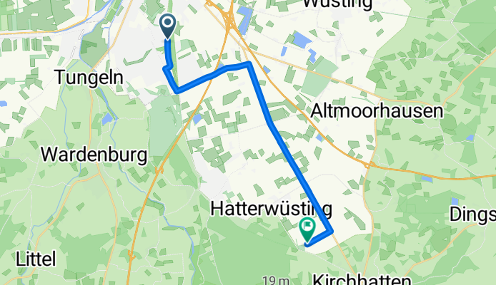
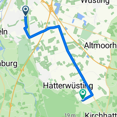
Route template
Oldenburg to Hatten

- 1 h 14 min
- Duration
- 18.5 km
- Distance
- 38 m
- Ascent
- 16 m
- Descent
- 15.1 km/h
- Avg. speed
- 34 m
- Max. altitude
This scenic cycling route takes you from Oldenburg to Hatten, covering just over 18.5 km. Kick things off in Oldenburg, a vibrant university city in Lower Saxony known for its lovely old town, historic castle, and lush parks. As you pedal out of the city, you'll roll along mostly paved paths and quiet country roads—perfect for a stress-free ride. The terrain is gentle, with only a gradual ascent of about 38 meters and a smooth descent into Hatten.
The journey winds south through farmland and small villages, letting you soak up the tranquil North German countryside. About two-thirds of the route runs along bike paths, so you can relax and enjoy the scenery. You’ll also find a stretch with classic paving stones—there’s some old-world charm!
Your ride ends in Hatten, a peaceful rural community famous for its natural parks and woodlands. If you have time, explore the Wild- und Freizeitpark Schwarze Heide or grab a bite at a cozy café. All in all, it’s a breezy ride that combines urban highlights with the calm of the countryside—ideal for a relaxed day out on two wheels!
Community
Top users in this region


From our community
The best bike routes from Oldenburg to Hatten

OL - Stau - Huntewiesen - Bornhorst - Blankenburg - Wuestingg
Cycling route in Oldenburg, Lower Saxony, Germany
- 25.3 km
- Distance
- 29 m
- Ascent
- 28 m
- Descent

Oldenburg - Kirchhatten
Cycling route in Oldenburg, Lower Saxony, Germany
- 25.3 km
- Distance
- 42 m
- Ascent
- 31 m
- Descent

Am Drielaker Kanal 8A, Oldenburg nach Kimmer Straße 7, Hatten
Cycling route in Oldenburg, Lower Saxony, Germany
- 22.8 km
- Distance
- 78 m
- Ascent
- 50 m
- Descent

Spargeltour 2017
Cycling route in Oldenburg, Lower Saxony, Germany
- 20.6 km
- Distance
- 13 m
- Ascent
- 12 m
- Descent

Route nach Ströhenweg 12A, Hude
Cycling route in Oldenburg, Lower Saxony, Germany
- 19.2 km
- Distance
- 30 m
- Ascent
- 72 m
- Descent


Route von Gagelweg 5, Oldenburg
Cycling route in Oldenburg, Lower Saxony, Germany
- 21.8 km
- Distance
- 42 m
- Ascent
- 43 m
- Descent

High-Speed-Strecke
Cycling route in Oldenburg, Lower Saxony, Germany
- 31.2 km
- Distance
- 55 m
- Ascent
- 90 m
- Descent

Route nach Ströhenweg 12A, Hude
Cycling route in Oldenburg, Lower Saxony, Germany
- 28 km
- Distance
- 71 m
- Ascent
- 111 m
- Descent


Test viele höhen Meter
Cycling route in Oldenburg, Lower Saxony, Germany
- 27.9 km
- Distance
- 35 m
- Ascent
- 31 m
- Descent
Discover more routes
 Route nach Ströhenweg 12A, Hude
- Distance
- 19.2 km
- Ascent
- 30 m
- Descent
- 72 m
- Location
- Oldenburg, Lower Saxony, Germany
 Ruhige Route
- Distance
- 15.1 km
- Ascent
- 21 m
- Descent
- 17 m
- Location
- Oldenburg, Lower Saxony, Germany
 Route von Gagelweg 5, Oldenburg
- Distance
- 21.8 km
- Ascent
- 42 m
- Descent
- 43 m
- Location
- Oldenburg, Lower Saxony, Germany
 High-Speed-Strecke
- Distance
- 31.2 km
- Ascent
- 55 m
- Descent
- 90 m
- Location
- Oldenburg, Lower Saxony, Germany
 Route nach Ströhenweg 12A, Hude
- Distance
- 28 km
- Ascent
- 71 m
- Descent
- 111 m
- Location
- Oldenburg, Lower Saxony, Germany
 D-OL-MA-65
- Distance
- 14.8 km
- Ascent
- 15 m
- Descent
- 4 m
- Location
- Oldenburg, Lower Saxony, Germany
 Ruhige Route
- Distance
- 27.1 km
- Ascent
- 78 m
- Descent
- 75 m
- Location
- Oldenburg, Lower Saxony, Germany
 Test viele höhen Meter
- Distance
- 27.9 km
- Ascent
- 35 m
- Descent
- 31 m
- Location
- Oldenburg, Lower Saxony, Germany
Routes from Oldenburg
Cycling day trip from
Oldenburg to Varel
Cycling day trip from
Oldenburg to Bremen
Quick ride by bicycle from
Oldenburg to Wiefelstede
Quick ride by bicycle from
Oldenburg to Rastede