
Route template
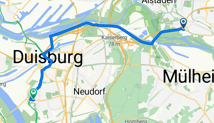
Mülheim to Hochfeld

- 48 min
- Duration
- 13.1 km
- Distance
- 62 m
- Ascent
- 67 m
- Descent
- 16.5 km/h
- Avg. speed
- 83 m
- Max. altitude
This ride takes you from the lively district of Mülheim, known for its historic industrial flair and riverside parks, down to Hochfeld—a diverse neighborhood in Duisburg with a strong working-class heritage. Covering just over 13 km, the route is mostly flat, so it’s great for an easy-paced cruise. You’ll be pedaling primarily on paved and asphalted surfaces, threading through lots of quiet roads and cycle paths, with only the odd short jump onto a busier stretch.
Expect a little urban scenery with patches of green along the Ruhr and the wider Ruhrgebiet. About two-thirds of your ride travels on less trafficked roads or dedicated paths, so it’s pretty relaxing. Hochfeld awaits at the end, right by the Rhine, and you might spot the impressive arches of the Hochfelder Eisenbahnbrücke nearby.
All in all, this is a straightforward, city-to-city pedal—perfect for a leisurely afternoon exploring the region’s industrial roots and river landscapes!
Community
Top users in this region


From our community
The best bike routes from Mülheim to Hochfeld

Abkürzung Mülheim nach Duisburg
Cycling route in Mülheim, North Rhine-Westphalia, Germany
- 5.7 km
- Distance
- 17 m
- Ascent
- 30 m
- Descent

mülheim seeenplatte
Cycling route in Mülheim, North Rhine-Westphalia, Germany
- 11 km
- Distance
- 83 m
- Ascent
- 98 m
- Descent

RRZ Heissen
Cycling route in Mülheim, North Rhine-Westphalia, Germany
- 18.9 km
- Distance
- 110 m
- Ascent
- 117 m
- Descent

MH-Entenfang
Cycling route in Mülheim, North Rhine-Westphalia, Germany
- 12.2 km
- Distance
- 78 m
- Ascent
- 139 m
- Descent

Bester Hinweg
Cycling route in Mülheim, North Rhine-Westphalia, Germany
- 14.9 km
- Distance
- 75 m
- Ascent
- 101 m
- Descent

1Thomas-liebevoll
Cycling route in Mülheim, North Rhine-Westphalia, Germany
- 35 km
- Distance
- 271 m
- Ascent
- 269 m
- Descent
Steinkampstraße nach Lindenstraße
Cycling route in Mülheim, North Rhine-Westphalia, Germany
- 10.6 km
- Distance
- 25 m
- Ascent
- 25 m
- Descent
Leineweberstraße, Mülheim an der Ruhr nach Kruppstraße, Duisburg
Cycling route in Mülheim, North Rhine-Westphalia, Germany
- 8.6 km
- Distance
- 67 m
- Ascent
- 69 m
- Descent

6 Seenplatte
Cycling route in Mülheim, North Rhine-Westphalia, Germany
- 9.9 km
- Distance
- 59 m
- Ascent
- 99 m
- Descent

Haninchen
Cycling route in Mülheim, North Rhine-Westphalia, Germany
- 15.1 km
- Distance
- 96 m
- Ascent
- 152 m
- Descent

RS1 Ende
Cycling route in Mülheim, North Rhine-Westphalia, Germany
- 10.9 km
- Distance
- 93 m
- Ascent
- 95 m
- Descent

Beste Route
Cycling route in Mülheim, North Rhine-Westphalia, Germany
- 14.9 km
- Distance
- 82 m
- Ascent
- 115 m
- Descent
Discover more routes
 Bester Hinweg
- Distance
- 14.9 km
- Ascent
- 75 m
- Descent
- 101 m
- Location
- Mülheim, North Rhine-Westphalia, Germany
 1Thomas-liebevoll
- Distance
- 35 km
- Ascent
- 271 m
- Descent
- 269 m
- Location
- Mülheim, North Rhine-Westphalia, Germany
 Steinkampstraße nach Lindenstraße
- Distance
- 10.6 km
- Ascent
- 25 m
- Descent
- 25 m
- Location
- Mülheim, North Rhine-Westphalia, Germany
 Leineweberstraße, Mülheim an der Ruhr nach Kruppstraße, Duisburg
- Distance
- 8.6 km
- Ascent
- 67 m
- Descent
- 69 m
- Location
- Mülheim, North Rhine-Westphalia, Germany
 6 Seenplatte
- Distance
- 9.9 km
- Ascent
- 59 m
- Descent
- 99 m
- Location
- Mülheim, North Rhine-Westphalia, Germany
 Haninchen
- Distance
- 15.1 km
- Ascent
- 96 m
- Descent
- 152 m
- Location
- Mülheim, North Rhine-Westphalia, Germany
 RS1 Ende
- Distance
- 10.9 km
- Ascent
- 93 m
- Descent
- 95 m
- Location
- Mülheim, North Rhine-Westphalia, Germany
 Beste Route
- Distance
- 14.9 km
- Ascent
- 82 m
- Descent
- 115 m
- Location
- Mülheim, North Rhine-Westphalia, Germany
Routes from Mülheim
Cycling day trip from
Mülheim to Ratingen
Cycling day trip from
Mülheim to Bottrop
Quick ride by bicycle from
Mülheim to Oberhausen
Quick ride by bicycle from
Mülheim to Duisburg
Routes to Hochfeld
Cycling day trip from
Essen to Hochfeld
Cycling day trip from
Ratingen to Hochfeld
Quick ride by bicycle from
Oberhausen to Hochfeld
Quick ride by bicycle from
Moers to Hochfeld