
By bicycle from Hochheim am Main to Mainz
Customize your own route based on our template or discover how our community prefers to cycle from Hochheim am Main to Mainz.
Route template
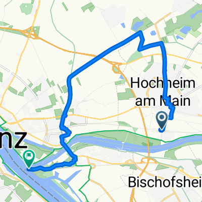
Hochheim am Main to Mainz

- 44 min
- Duration
- 12.2 km
- Distance
- 60 m
- Ascent
- 62 m
- Descent
- 16.8 km/h
- Avg. speed
- 131 m
- Max. altitude
This is a perfect ride if you want a laid-back day exploring the heart of the Rheingau region! Starting from Hochheim am Main—a charming wine town famous for its Riesling and centuries-old vineyards—you’re treated to gentle scenery the whole way through. The route is just over 12 km, so it’s easily done in under an hour, even with a few breaks to snap riverside photos or check out local sights.
Most of your journey follows quiet roads and smooth paths, with excellent riding surfaces (over 97% paved), making it comfortable even for casual cyclists. You’ll roll through the scenic countryside, enjoying an easy ride with minimal elevation, and there are just a few gentle ups and downs to keep things interesting.
The trip winds up in Mainz, a bustling university city loaded with history—think Gutenberg and Roman ruins. Grab a coffee in the picturesque old town before heading back or exploring more. All in all, it’s a super pleasant, low-stress ride with plenty of options to linger in gorgeous spots along the way.
Community
Top users in this region


From our community
The best bike routes from Hochheim am Main to Mainz

kleine Rheinrunde von Mainz bis Oestrich
Cycling route in Hochheim am Main, Hesse, Germany
- 48.6 km
- Distance
- 80 m
- Ascent
- 76 m
- Descent

kleine Rheinrunde von Mainz bis Oestrich CLONED FROM ROUTE 550499 CLONED FROM ROUTE 2048172
Cycling route in Hochheim am Main, Hesse, Germany
- 51.3 km
- Distance
- 75 m
- Ascent
- 109 m
- Descent

mcdonalds aussen rum
Cycling route in Hochheim am Main, Hesse, Germany
- 9.3 km
- Distance
- 22 m
- Ascent
- 63 m
- Descent

Im Eigen 11–13, Hochheim am Main nach Zitadelle 1F, Mainz
Cycling route in Hochheim am Main, Hesse, Germany
- 8.8 km
- Distance
- 44 m
- Ascent
- 51 m
- Descent

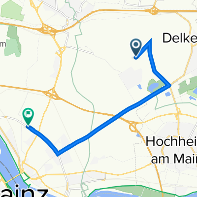
Rhein/Main Rundroute
Cycling route in Hochheim am Main, Hesse, Germany
- 12.1 km
- Distance
- 55 m
- Ascent
- 63 m
- Descent

20150826_192024.gpx
Cycling route in Hochheim am Main, Hesse, Germany
- 9.4 km
- Distance
- 86 m
- Ascent
- 44 m
- Descent

Mechthildshausen 1, Wiesbaden nach Im Sampel 60, Wiesbaden
Cycling route in Hochheim am Main, Hesse, Germany
- 6.1 km
- Distance
- 10 m
- Ascent
- 58 m
- Descent

Straubinger Straße 5–9, Wiesbaden nach Jakob-Schick-Straße 1, Wiesbaden
Cycling route in Hochheim am Main, Hesse, Germany
- 6.9 km
- Distance
- 158 m
- Ascent
- 205 m
- Descent

Wiesbaden Centre, Wiesbaden to Jakob-Schick-Straße 16, Wiesbaden
Cycling route in Hochheim am Main, Hesse, Germany
- 6 km
- Distance
- 3 m
- Ascent
- 55 m
- Descent

Bernhard-Walch-Weg 5, Hochheim am Main nach Schillerplatz, Mainz
Cycling route in Hochheim am Main, Hesse, Germany
- 8.7 km
- Distance
- 18 m
- Ascent
- 42 m
- Descent

Wiesbaden to Otto-Suhr-Ring, Wiesbaden
Cycling route in Hochheim am Main, Hesse, Germany
- 7.9 km
- Distance
- 9 m
- Ascent
- 55 m
- Descent

Wiesbaden to Draiser Straße 119, Mainz
Cycling route in Hochheim am Main, Hesse, Germany
- 12.9 km
- Distance
- 52 m
- Ascent
- 62 m
- Descent
Discover more routes
 Rhein/Main Rundroute
- Distance
- 12.1 km
- Ascent
- 55 m
- Descent
- 63 m
- Location
- Hochheim am Main, Hesse, Germany
 20150826_192024.gpx
- Distance
- 9.4 km
- Ascent
- 86 m
- Descent
- 44 m
- Location
- Hochheim am Main, Hesse, Germany
 Mechthildshausen 1, Wiesbaden nach Im Sampel 60, Wiesbaden
- Distance
- 6.1 km
- Ascent
- 10 m
- Descent
- 58 m
- Location
- Hochheim am Main, Hesse, Germany
 Straubinger Straße 5–9, Wiesbaden nach Jakob-Schick-Straße 1, Wiesbaden
- Distance
- 6.9 km
- Ascent
- 158 m
- Descent
- 205 m
- Location
- Hochheim am Main, Hesse, Germany
 Wiesbaden Centre, Wiesbaden to Jakob-Schick-Straße 16, Wiesbaden
- Distance
- 6 km
- Ascent
- 3 m
- Descent
- 55 m
- Location
- Hochheim am Main, Hesse, Germany
 Bernhard-Walch-Weg 5, Hochheim am Main nach Schillerplatz, Mainz
- Distance
- 8.7 km
- Ascent
- 18 m
- Descent
- 42 m
- Location
- Hochheim am Main, Hesse, Germany
 Wiesbaden to Otto-Suhr-Ring, Wiesbaden
- Distance
- 7.9 km
- Ascent
- 9 m
- Descent
- 55 m
- Location
- Hochheim am Main, Hesse, Germany
 Wiesbaden to Draiser Straße 119, Mainz
- Distance
- 12.9 km
- Ascent
- 52 m
- Descent
- 62 m
- Location
- Hochheim am Main, Hesse, Germany
Routes from Hochheim am Main
By bicycle from
Hochheim am Main to Wiesbaden
Routes to Mainz
Cycling day trip from
Rüdesheim am Rhein to Mainz
Cycling day trip from
Worms to Mainz
By bicycle from
Klein-Winternheim to Mainz
By bicycle from
Budenheim to Mainz