
Quick ride by bicycle from Hilpoltstein to Roth
Customize your own route based on our template or discover how our community prefers to cycle from Hilpoltstein to Roth.
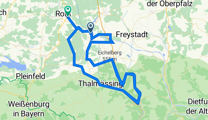
Route template
Hilpoltstein to Roth

- 53 min
- Duration
- 13.8 km
- Distance
- 82 m
- Ascent
- 122 m
- Descent
- 15.8 km/h
- Avg. speed
- 397 m
- Max. altitude
Set off from Hilpoltstein, a charming Franconian town famous for its medieval castle and as a classic stop on the Main-Danube Canal. Your ride to Roth is just under 14 kilometers, with mostly gentle slopes—expect a bit of a climb at the start, balanced by more downhill sections closer to Roth.
The route is a nice mix: about half paved, with plenty of smooth asphalt stretches perfect for cruising, but don’t be surprised by sections of gravel and unpaved track (around a third of the ride), which add a little adventure. This makes it well-suited for hybrid or gravel bikes. You'll mostly stick to quiet farm roads and woodland tracks, so expect peaceful countryside views and very little car traffic.
Finish in Roth, known for its jazz festival and as the vibrant heart of the Rothsee region—perfect for a post-ride stroll or snack. All in, it’s a relaxed ride ideal for anyone looking to enjoy some classic Bavarian scenery and a slice of local culture.
Community
Top users in this region


From our community
The best bike routes from Hilpoltstein to Roth

Rothsee-Traithlon Radstrecke
Cycling route in Hilpoltstein, Bavaria, Germany
- 41.1 km
- Distance
- 311 m
- Ascent
- 331 m
- Descent

Challenge Roth 2010 Aufzeichnung
Cycling route in Hilpoltstein, Bavaria, Germany
- 175.7 km
- Distance
- 742 m
- Ascent
- 768 m
- Descent

Challenge Roth
Cycling route in Hilpoltstein, Bavaria, Germany
- 178.8 km
- Distance
- 741 m
- Ascent
- 770 m
- Descent

DE_Roth Tri Total Trip
Cycling route in Hilpoltstein, Bavaria, Germany
- 100 km
- Distance
- 640 m
- Ascent
- 672 m
- Descent

Challenge Roth
Cycling route in Hilpoltstein, Bavaria, Germany
- 178.8 km
- Distance
- 731 m
- Ascent
- 762 m
- Descent

Radstrecke Challenge Roth_1
Cycling route in Hilpoltstein, Bavaria, Germany
- 178.3 km
- Distance
- 742 m
- Ascent
- 774 m
- Descent


IM Roth bike
Cycling route in Hilpoltstein, Bavaria, Germany
- 178.4 km
- Distance
- 767 m
- Ascent
- 807 m
- Descent

Radstrecke Challenge Roth
Cycling route in Hilpoltstein, Bavaria, Germany
- 178.5 km
- Distance
- 1,665 m
- Ascent
- 1,693 m
- Descent

Challenge Roth 2017
Cycling route in Hilpoltstein, Bavaria, Germany
- 178.3 km
- Distance
- 746 m
- Ascent
- 776 m
- Descent
DATEV Challenge Roth Bike Course 180km - DATEV Challenge Roth Bike Course 180km - 2023
Cycling route in Hilpoltstein, Bavaria, Germany
- 178 km
- Distance
- 1,765 m
- Ascent
- 1,790 m
- Descent

Am Rothsee 2, Hilpoltstein nach Straße ohne Straßennamen, Roth
Cycling route in Hilpoltstein, Bavaria, Germany
- 10.5 km
- Distance
- 16 m
- Ascent
- 25 m
- Descent
Discover more routes
 Challenge Roth
- Distance
- 178.8 km
- Ascent
- 731 m
- Descent
- 762 m
- Location
- Hilpoltstein, Bavaria, Germany
 Radstrecke Challenge Roth_1
- Distance
- 178.3 km
- Ascent
- 742 m
- Descent
- 774 m
- Location
- Hilpoltstein, Bavaria, Germany
 D-BY-Roth
- Distance
- 178.5 km
- Ascent
- 1,676 m
- Descent
- 1,692 m
- Location
- Hilpoltstein, Bavaria, Germany
 IM Roth bike
- Distance
- 178.4 km
- Ascent
- 767 m
- Descent
- 807 m
- Location
- Hilpoltstein, Bavaria, Germany
 Radstrecke Challenge Roth
- Distance
- 178.5 km
- Ascent
- 1,665 m
- Descent
- 1,693 m
- Location
- Hilpoltstein, Bavaria, Germany
 Challenge Roth 2017
- Distance
- 178.3 km
- Ascent
- 746 m
- Descent
- 776 m
- Location
- Hilpoltstein, Bavaria, Germany
 DATEV Challenge Roth Bike Course 180km - DATEV Challenge Roth Bike Course 180km - 2023
- Distance
- 178 km
- Ascent
- 1,765 m
- Descent
- 1,790 m
- Location
- Hilpoltstein, Bavaria, Germany
 Am Rothsee 2, Hilpoltstein nach Straße ohne Straßennamen, Roth
- Distance
- 10.5 km
- Ascent
- 16 m
- Descent
- 25 m
- Location
- Hilpoltstein, Bavaria, Germany