
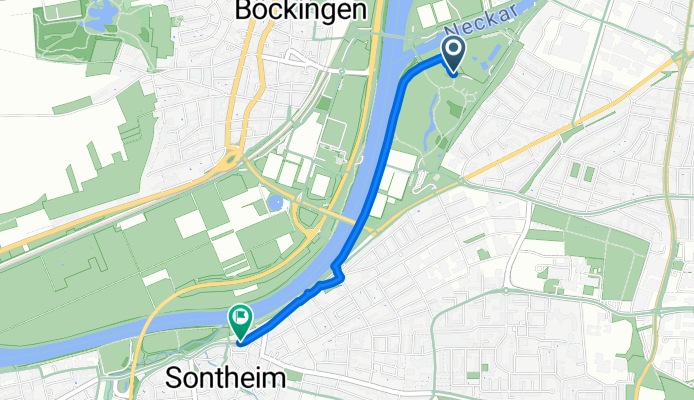
Route template
Heilbronn to Flein

- 24 min
- Duration
- 6.9 km
- Distance
- 71 m
- Ascent
- 48 m
- Descent
- 17.4 km/h
- Avg. speed
- 210 m
- Max. altitude
Ready for a pleasant spin out of the city? This easy 7 km ride takes you from Heilbronn’s bustling center, well-known for its wine tradition and charming Neckar waterfront, straight south to the peaceful wine village of Flein. You’ll mostly cruise on smooth paved paths and quiet roads—nearly all asphalt—so it’s super comfortable for any bike.
The route is gentle, with just a bit of climbing (about 70 meters), perfect for a leisurely pace. Along the way, you’ll leave Heilbronn’s urban energy behind and enjoy sections through vineyards and green spaces common to this region. Flein, your destination, is small but picturesque, famous locally for its excellent Riesling and scenic surroundings.
If you’re into wine tasting, treat yourself in Flein’s cozy local taverns after the ride. Whether you’re a local or just visiting, this relaxed cycling route offers a great taste of Baden-Württemberg’s landscapes and culture.
Community
Top users in this region


From our community
The best bike routes from Heilbronn to Flein

scheweinsbergturm
Cycling route in Heilbronn, Baden-Wurttemberg, Germany
- 8.9 km
- Distance
- 165 m
- Ascent
- 37 m
- Descent

Heilbronn Untere Kanalstr. 34
Cycling route in Heilbronn, Baden-Wurttemberg, Germany
- 4.5 km
- Distance
- 17 m
- Ascent
- 16 m
- Descent

Recovered Route
Cycling route in Heilbronn, Baden-Wurttemberg, Germany
- 11 km
- Distance
- 32 m
- Ascent
- 39 m
- Descent

Böck
Cycling route in Heilbronn, Baden-Wurttemberg, Germany
- 1 km
- Distance
- 0 m
- Ascent
- 0 m
- Descent

Heilbronn - Flein - Schweinsbergturm - Flein - Heilbronn
Cycling route in Heilbronn, Baden-Wurttemberg, Germany
- 19.5 km
- Distance
- 299 m
- Ascent
- 258 m
- Descent

Bachstraße 25, Heilbronn nach Altenbergweg 38, Flein
Cycling route in Heilbronn, Baden-Wurttemberg, Germany
- 7.8 km
- Distance
- 67 m
- Ascent
- 31 m
- Descent
Neckarhalde nach Horkheimer Straße
Cycling route in Heilbronn, Baden-Wurttemberg, Germany
- 2.3 km
- Distance
- 17 m
- Ascent
- 69 m
- Descent

Neckartalstraße, Heilbronn to Neckartalstraße, Heilbronn
Cycling route in Heilbronn, Baden-Wurttemberg, Germany
- 0.5 km
- Distance
- 0 m
- Ascent
- 0 m
- Descent

HN - Öhringen - Bad Friedrichshall - HN - Flein
Cycling route in Heilbronn, Baden-Wurttemberg, Germany
- 79.2 km
- Distance
- 512 m
- Ascent
- 445 m
- Descent

Riedstraße 2, Heilbronn nach Haigern 7, Talheim
Cycling route in Heilbronn, Baden-Wurttemberg, Germany
- 8.7 km
- Distance
- 168 m
- Ascent
- 89 m
- Descent
Kalistraße, Heilbronn nach Uhdestraße, Heilbronn
Cycling route in Heilbronn, Baden-Wurttemberg, Germany
- 4.9 km
- Distance
- 28 m
- Ascent
- 8 m
- Descent

Großgartacher Straße 61, Heilbronn nach Sontheimer Straße 35, Flein
Cycling route in Heilbronn, Baden-Wurttemberg, Germany
- 6.2 km
- Distance
- 200 m
- Ascent
- 177 m
- Descent
Discover more routes
 Heilbronn - Flein - Schweinsbergturm - Flein - Heilbronn
- Distance
- 19.5 km
- Ascent
- 299 m
- Descent
- 258 m
- Location
- Heilbronn, Baden-Wurttemberg, Germany
 Bachstraße 25, Heilbronn nach Altenbergweg 38, Flein
- Distance
- 7.8 km
- Ascent
- 67 m
- Descent
- 31 m
- Location
- Heilbronn, Baden-Wurttemberg, Germany
 Neckarhalde nach Horkheimer Straße
- Distance
- 2.3 km
- Ascent
- 17 m
- Descent
- 69 m
- Location
- Heilbronn, Baden-Wurttemberg, Germany
 Neckartalstraße, Heilbronn to Neckartalstraße, Heilbronn
- Distance
- 0.5 km
- Ascent
- 0 m
- Descent
- 0 m
- Location
- Heilbronn, Baden-Wurttemberg, Germany
 HN - Öhringen - Bad Friedrichshall - HN - Flein
- Distance
- 79.2 km
- Ascent
- 512 m
- Descent
- 445 m
- Location
- Heilbronn, Baden-Wurttemberg, Germany
 Riedstraße 2, Heilbronn nach Haigern 7, Talheim
- Distance
- 8.7 km
- Ascent
- 168 m
- Descent
- 89 m
- Location
- Heilbronn, Baden-Wurttemberg, Germany
- Kalistraße, Heilbronn nach Uhdestraße, Heilbronn
- Distance
- 4.9 km
- Ascent
- 28 m
- Descent
- 8 m
- Location
- Heilbronn, Baden-Wurttemberg, Germany
 Großgartacher Straße 61, Heilbronn nach Sontheimer Straße 35, Flein
- Distance
- 6.2 km
- Ascent
- 200 m
- Descent
- 177 m
- Location
- Heilbronn, Baden-Wurttemberg, Germany
Routes from Heilbronn
Cycling day trip from
Heilbronn to Heidelberg