
By bicycle from Marienthal to Steilshoop
Customize your own route based on our template or discover how our community prefers to cycle from Marienthal to Steilshoop.
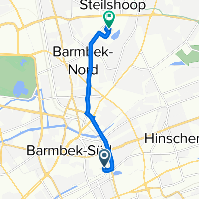
Route template
Marienthal to Steilshoop

- 48 min
- Duration
- 11.8 km
- Distance
- 41 m
- Ascent
- 24 m
- Descent
- 14.6 km/h
- Avg. speed
- 32 m
- Max. altitude
Set off from the leafy residential streets of Marienthal, a peaceful Hamburg neighborhood known for its historic villas and green spaces. Your route to Steilshoop covers about 12 km, winding mostly along quiet, paved roads with a gentle ascent—perfect for an easy-going ride.
Soon after starting, you’ll pass through a mix of tranquil streets and cycle-friendly paths, making this a relaxed route even for novice cyclists. The ride weaves through some of Hamburg’s lesser-known corners, so keep an eye out for local parks and allotment gardens along the way. With around 65% asphalt and more than 85% paved surfaces, you’re in for a smooth journey.
Reaching Steilshoop, you’ll find a vibrant, multicultural district famous for its distinct 1970s apartment blocks and rich community life. Steilshoop is also surrounded by plenty of green spaces—perfect for a quick breather after your ride! Overall, this route is a great way to connect two different sides of Hamburg and experience the city from a cyclist’s perspective.
Community
Top users in this region

From our community
The best bike routes from Marienthal to Steilshoop

Friedenstraße nach Rahnstraße
Cycling route in Marienthal, City state of Hamburg, Germany
- 5.2 km
- Distance
- 18 m
- Ascent
- 14 m
- Descent

Schrecklich
Cycling route in Marienthal, City state of Hamburg, Germany
- 21.2 km
- Distance
- 59 m
- Ascent
- 60 m
- Descent

Brauhausstraße 5, Hamburg to Georg-Raloff-Ring 46, Hamburg
Cycling route in Marienthal, City state of Hamburg, Germany
- 4.9 km
- Distance
- 36 m
- Ascent
- 35 m
- Descent

Brauhausstieg 15, Hamburg nach Werner-Otto-Straße 13–15, Hamburg
Cycling route in Marienthal, City state of Hamburg, Germany
- 4 km
- Distance
- 45 m
- Ascent
- 33 m
- Descent

Brauhausstieg 15, Hamburg nach Werner-Otto-Straße 13M, Hamburg
Cycling route in Marienthal, City state of Hamburg, Germany
- 4 km
- Distance
- 20 m
- Ascent
- 14 m
- Descent

Brauhausstieg 15, Hamburg nach Werner-Otto-Straße 13–15, Hamburg
Cycling route in Marienthal, City state of Hamburg, Germany
- 4.1 km
- Distance
- 22 m
- Ascent
- 19 m
- Descent

Caspar-Voght-Straße 50, Hamburg nach Berner Chaussee 49, Hamburg
Cycling route in Marienthal, City state of Hamburg, Germany
- 8.6 km
- Distance
- 31 m
- Ascent
- 25 m
- Descent

Brauhausstieg 15, Hamburg nach Werner-Otto-Straße 13, Hamburg
Cycling route in Marienthal, City state of Hamburg, Germany
- 4.1 km
- Distance
- 33 m
- Ascent
- 27 m
- Descent

Grete-Zabe-Weg 32, Hamburg to Georg-Raloff-Ring 46, Hamburg
Cycling route in Marienthal, City state of Hamburg, Germany
- 4.2 km
- Distance
- 14 m
- Ascent
- 7 m
- Descent

Friedrichsberg, Hamburg nach Edwin-Scharff-Ring 50, Hamburg
Cycling route in Marienthal, City state of Hamburg, Germany
- 5.9 km
- Distance
- 30 m
- Ascent
- 14 m
- Descent

Thiedeweg 46, Hamburg nach Steilshooper Allee 407F, Hamburg
Cycling route in Marienthal, City state of Hamburg, Germany
- 4.1 km
- Distance
- 20 m
- Ascent
- 18 m
- Descent

Friedrichsberg, Hamburg nach Edwin-Scharff-Ring 52, Hamburg
Cycling route in Marienthal, City state of Hamburg, Germany
- 6.9 km
- Distance
- 71 m
- Ascent
- 55 m
- Descent
Discover more routes
 Brauhausstieg 15, Hamburg nach Werner-Otto-Straße 13M, Hamburg
- Distance
- 4 km
- Ascent
- 20 m
- Descent
- 14 m
- Location
- Marienthal, City state of Hamburg, Germany
 Brauhausstieg 15, Hamburg nach Werner-Otto-Straße 13–15, Hamburg
- Distance
- 4.1 km
- Ascent
- 22 m
- Descent
- 19 m
- Location
- Marienthal, City state of Hamburg, Germany
 Caspar-Voght-Straße 50, Hamburg nach Berner Chaussee 49, Hamburg
- Distance
- 8.6 km
- Ascent
- 31 m
- Descent
- 25 m
- Location
- Marienthal, City state of Hamburg, Germany
 Brauhausstieg 15, Hamburg nach Werner-Otto-Straße 13, Hamburg
- Distance
- 4.1 km
- Ascent
- 33 m
- Descent
- 27 m
- Location
- Marienthal, City state of Hamburg, Germany
 Grete-Zabe-Weg 32, Hamburg to Georg-Raloff-Ring 46, Hamburg
- Distance
- 4.2 km
- Ascent
- 14 m
- Descent
- 7 m
- Location
- Marienthal, City state of Hamburg, Germany
 Friedrichsberg, Hamburg nach Edwin-Scharff-Ring 50, Hamburg
- Distance
- 5.9 km
- Ascent
- 30 m
- Descent
- 14 m
- Location
- Marienthal, City state of Hamburg, Germany
 Thiedeweg 46, Hamburg nach Steilshooper Allee 407F, Hamburg
- Distance
- 4.1 km
- Ascent
- 20 m
- Descent
- 18 m
- Location
- Marienthal, City state of Hamburg, Germany
 Friedrichsberg, Hamburg nach Edwin-Scharff-Ring 52, Hamburg
- Distance
- 6.9 km
- Ascent
- 71 m
- Descent
- 55 m
- Location
- Marienthal, City state of Hamburg, Germany
Routes from Marienthal
Cycling day trip from
Marienthal to Reinbek
By bicycle from
Marienthal to Borgfelde
By bicycle from
Marienthal to Hamburg
Routes to Steilshoop
By bicycle from
Farmsen-Berne to Steilshoop