

By bicycle from Frankfurt am Main to Bad Homburg
Customize your own route based on our template or discover how our community prefers to cycle from Frankfurt am Main to Bad Homburg.
Route template
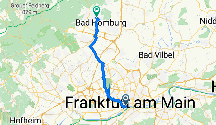
Frankfurt am Main to Bad Homburg

- 1 h 3 min
- Duration
- 17.8 km
- Distance
- 123 m
- Ascent
- 49 m
- Descent
- 16.9 km/h
- Avg. speed
- 187 m
- Max. altitude
Frankfurt am Main to Bad Homburg – Scenic Ride Just North of the City
Kick off your ride in the bustling heart of Frankfurt am Main, one of Germany’s financial and cultural capitals, known for its futuristic skyline and riverside cycling paths. Heading north, you’ll leave the city behind and wind your way along mostly smooth, paved surfaces (with just a touch of adventure on some paving stones and gravel). The route covers about 18 km with a gentle ascent of around 120 meters, so you’ll get a nice workout without anything too steep.
Most of your journey will be on quiet roads and cycle paths, making it relaxed and beginner-friendly. As you approach your destination, you’ll be welcomed by the charm of Bad Homburg, famous for its grand spa gardens and historic old town. There’s hardly any rough terrain—mainly smooth tracks, with most of your route flanked by leafy parklands or peaceful suburbs.
Perfect for a leisurely weekend ride, this route offers a taste of both city life and the green calm of the Taunus foothills, topped off with a bit of local history at either end. Don’t forget to explore Bad Homburg’s famous Kurpark or the picturesque castle once you arrive!
Community
Top users in this region


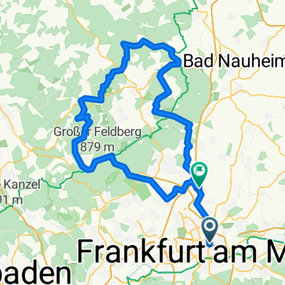
From our community
The best bike routes from Frankfurt am Main to Bad Homburg

Niddapark Bad. Hbg.
Cycling route in Frankfurt am Main, Hesse, Germany
- 15.3 km
- Distance
- 124 m
- Ascent
- 45 m
- Descent

Westbahnhof - N-E (alternativ)
Cycling route in Frankfurt am Main, Hesse, Germany
- 19.4 km
- Distance
- 100 m
- Ascent
- 67 m
- Descent

Hölderlin-Pfad_Hoelderlinpfad
Cycling route in Frankfurt am Main, Hesse, Germany
- 21.9 km
- Distance
- 164 m
- Ascent
- 72 m
- Descent

Feierabend Mai 18
Cycling route in Frankfurt am Main, Hesse, Germany
- 27.8 km
- Distance
- 151 m
- Ascent
- 117 m
- Descent

Vom Nordend nach Nieder-Eschbach
Cycling route in Frankfurt am Main, Hesse, Germany
- 108 km
- Distance
- 1,169 m
- Ascent
- 1,158 m
- Descent

Panoramabad - Home
Cycling route in Frankfurt am Main, Hesse, Germany
- 10.8 km
- Distance
- 68 m
- Ascent
- 62 m
- Descent

Colosseo to LTS
Cycling route in Frankfurt am Main, Hesse, Germany
- 17.3 km
- Distance
- 128 m
- Ascent
- 103 m
- Descent

BB Ost - Hofhausstr. - Berkersh. - Home
Cycling route in Frankfurt am Main, Hesse, Germany
- 17.6 km
- Distance
- 161 m
- Ascent
- 91 m
- Descent

Kiesstraße 25, Frankfurt am Main nach Karl-Horn-Straße 16, Bad Homburg vor der Höhe
Cycling route in Frankfurt am Main, Hesse, Germany
- 17.6 km
- Distance
- 144 m
- Ascent
- 34 m
- Descent
Gallusanlage 2, Frankfurt am Main nach Gluckensteinweg 36, Bad Homburg vor der Höhe
Cycling route in Frankfurt am Main, Hesse, Germany
- 18.8 km
- Distance
- 116 m
- Ascent
- 29 m
- Descent


Bockenheim - Niedereschbach
Cycling route in Frankfurt am Main, Hesse, Germany
- 12.3 km
- Distance
- 78 m
- Ascent
- 49 m
- Descent
Discover more routes
 Vom Nordend nach Nieder-Eschbach
- Distance
- 108 km
- Ascent
- 1,169 m
- Descent
- 1,158 m
- Location
- Frankfurt am Main, Hesse, Germany
 Panoramabad - Home
- Distance
- 10.8 km
- Ascent
- 68 m
- Descent
- 62 m
- Location
- Frankfurt am Main, Hesse, Germany
 Colosseo to LTS
- Distance
- 17.3 km
- Ascent
- 128 m
- Descent
- 103 m
- Location
- Frankfurt am Main, Hesse, Germany
 BB Ost - Hofhausstr. - Berkersh. - Home
- Distance
- 17.6 km
- Ascent
- 161 m
- Descent
- 91 m
- Location
- Frankfurt am Main, Hesse, Germany
 Kiesstraße 25, Frankfurt am Main nach Karl-Horn-Straße 16, Bad Homburg vor der Höhe
- Distance
- 17.6 km
- Ascent
- 144 m
- Descent
- 34 m
- Location
- Frankfurt am Main, Hesse, Germany
 Gallusanlage 2, Frankfurt am Main nach Gluckensteinweg 36, Bad Homburg vor der Höhe
- Distance
- 18.8 km
- Ascent
- 116 m
- Descent
- 29 m
- Location
- Frankfurt am Main, Hesse, Germany
 bu - ikea
- Distance
- 14.2 km
- Ascent
- 76 m
- Descent
- 33 m
- Location
- Frankfurt am Main, Hesse, Germany
 Bockenheim - Niedereschbach
- Distance
- 12.3 km
- Ascent
- 78 m
- Descent
- 49 m
- Location
- Frankfurt am Main, Hesse, Germany
Routes from Frankfurt am Main
Cycling day trip from
Frankfurt am Main to Wiesbaden
Cycling day trip from
Frankfurt am Main to Kronberg
By bicycle from
Frankfurt am Main to Maintal
By bicycle from
Frankfurt am Main to Offenbach
Routes to Bad Homburg
By bicycle from
Bad Vilbel to Bad Homburg
By bicycle from
Steinbach am Taunus to Bad Homburg