
Quick ride by bicycle from Dossenheim to Wilhelmsfeld
Customize your own route based on our template or discover how our community prefers to cycle from Dossenheim to Wilhelmsfeld.
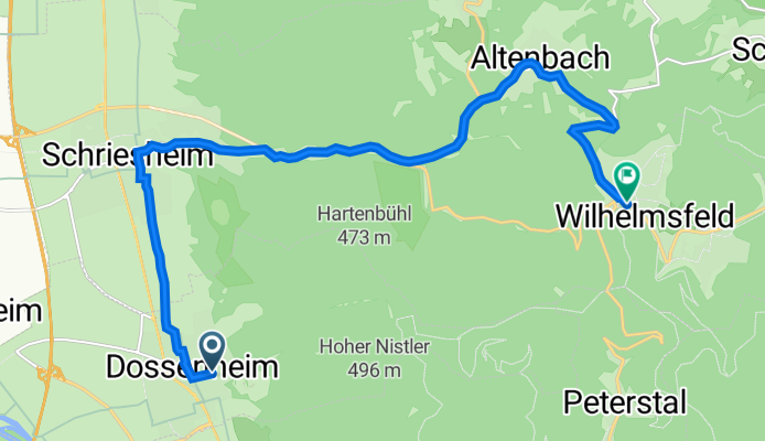
Route template
Dossenheim to Wilhelmsfeld

- 54 min
- Duration
- 10.5 km
- Distance
- 590 m
- Ascent
- 280 m
- Descent
- 11.8 km/h
- Avg. speed
- 559 m
- Max. altitude
Start your cycling adventure in the charming town of Dossenheim, nestled just a stone’s throw from Heidelberg. Known for its picturesque landscape and a penchant for outdoor activities, Dossenheim is the perfect kickoff point for this scenic ride.
Your journey to Wilhelmsfeld, a cozy village up in the Odenwald hills, will stretch about 10.5 kilometers — enough to get the heart pumping and the legs moving without feeling like a marathon. Expect a fair ascent of around 590 meters, so get ready to feel those leg muscles working their magic as you wind your way up towards your final destination.
The route is primarily paved with asphalt (76%), with touches of gravel providing a subtly rustic feeling under tire. It's a chill ride with 58% of your journey spent on quiet roads and nearly no traffic to worry about.
As you glide into Wilhelmsfeld, you're greeted by a peaceful atmosphere perfect for unwinding. This quaint village is known for its crisp air and stunning panoramic views, making the climb totally worth it. This ride is perfect for those who love nature, a bit of a workout, and a rewarding view at the end!
Community
Top users in this region


From our community
The best bike routes from Dossenheim to Wilhelmsfeld
Schlüsselweg 36, Dossenheim to Johann-Wilhelm-Straße 111, Wilhelmsfeld
Cycling route in Dossenheim, Baden-Wurttemberg, Germany
- 13.4 km
- Distance
- 521 m
- Ascent
- 202 m
- Descent

Rennstrecke Weisser Stein
Cycling route in Dossenheim, Baden-Wurttemberg, Germany
- 5.3 km
- Distance
- 396 m
- Ascent
- 118 m
- Descent

DO_Rimbachtal_WS
Cycling route in Dossenheim, Baden-Wurttemberg, Germany
- 18.8 km
- Distance
- 664 m
- Ascent
- 247 m
- Descent

49.450° N 8.687° W to 49.453° N 8.723° W
Cycling route in Dossenheim, Baden-Wurttemberg, Germany
- 5.2 km
- Distance
- 350 m
- Ascent
- 4 m
- Descent

49.450° N 8.687° W to 49.453° N 8.723° W
Cycling route in Dossenheim, Baden-Wurttemberg, Germany
- 5.2 km
- Distance
- 350 m
- Ascent
- 4 m
- Descent

Route nach Straße ohne Straßennamen, Heidelberg
Cycling route in Dossenheim, Baden-Wurttemberg, Germany
- 14.4 km
- Distance
- 578 m
- Ascent
- 347 m
- Descent

Route nach Straße ohne Straßennamen, Heidelberg
Cycling route in Dossenheim, Baden-Wurttemberg, Germany
- 14.4 km
- Distance
- 578 m
- Ascent
- 347 m
- Descent

WS_Hellenbach_Mühltal
Cycling route in Dossenheim, Baden-Wurttemberg, Germany
- 8.6 km
- Distance
- 532 m
- Ascent
- 88 m
- Descent

Mühltalstraße 108, Heidelberg to Am Weißen Stein 1, Dossenheim
Cycling route in Dossenheim, Baden-Wurttemberg, Germany
- 5.6 km
- Distance
- 440 m
- Ascent
- 39 m
- Descent

Route nach Weißer Stein 1, Dossenheim
Cycling route in Dossenheim, Baden-Wurttemberg, Germany
- 8.2 km
- Distance
- 462 m
- Ascent
- 95 m
- Descent

Weißer Stein Bergzeitfahren
Cycling route in Dossenheim, Baden-Wurttemberg, Germany
- 6.8 km
- Distance
- 530 m
- Ascent
- 86 m
- Descent

Rosenweg 16, Dossenheim nach Weißer Stein, Dossenheim
Cycling route in Dossenheim, Baden-Wurttemberg, Germany
- 8 km
- Distance
- 487 m
- Ascent
- 75 m
- Descent
Discover more routes
 49.450° N 8.687° W to 49.453° N 8.723° W
- Distance
- 5.2 km
- Ascent
- 350 m
- Descent
- 4 m
- Location
- Dossenheim, Baden-Wurttemberg, Germany
 Route nach Straße ohne Straßennamen, Heidelberg
- Distance
- 14.4 km
- Ascent
- 578 m
- Descent
- 347 m
- Location
- Dossenheim, Baden-Wurttemberg, Germany
 Route nach Straße ohne Straßennamen, Heidelberg
- Distance
- 14.4 km
- Ascent
- 578 m
- Descent
- 347 m
- Location
- Dossenheim, Baden-Wurttemberg, Germany
 WS_Hellenbach_Mühltal
- Distance
- 8.6 km
- Ascent
- 532 m
- Descent
- 88 m
- Location
- Dossenheim, Baden-Wurttemberg, Germany
 Mühltalstraße 108, Heidelberg to Am Weißen Stein 1, Dossenheim
- Distance
- 5.6 km
- Ascent
- 440 m
- Descent
- 39 m
- Location
- Dossenheim, Baden-Wurttemberg, Germany
 Route nach Weißer Stein 1, Dossenheim
- Distance
- 8.2 km
- Ascent
- 462 m
- Descent
- 95 m
- Location
- Dossenheim, Baden-Wurttemberg, Germany
 Weißer Stein Bergzeitfahren
- Distance
- 6.8 km
- Ascent
- 530 m
- Descent
- 86 m
- Location
- Dossenheim, Baden-Wurttemberg, Germany
 Rosenweg 16, Dossenheim nach Weißer Stein, Dossenheim
- Distance
- 8 km
- Ascent
- 487 m
- Descent
- 75 m
- Location
- Dossenheim, Baden-Wurttemberg, Germany
Routes from Dossenheim
Quick ride by bicycle from
Dossenheim to Heidelberg