
Cycling day trip from Crailsheim to Dinkelsbühl
Customize your own route based on our template or discover how our community prefers to cycle from Crailsheim to Dinkelsbühl.
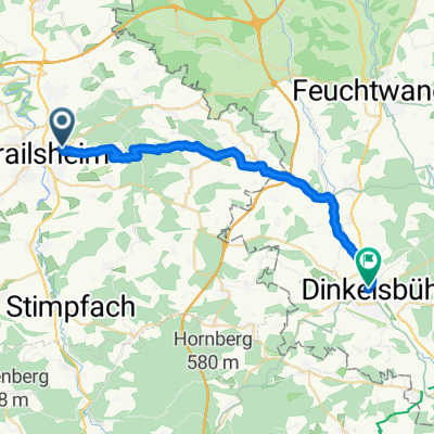
Route template
Crailsheim to Dinkelsbühl

- 1 h 40 min
- Duration
- 26.2 km
- Distance
- 259 m
- Ascent
- 222 m
- Descent
- 15.7 km/h
- Avg. speed
- 531 m
- Max. altitude
Ready for a scenic ride through the rolling Frankonian countryside? This 26 km cycling route takes you from Crailsheim, a lively town with a charming historic core and railway heritage, straight to the postcard-perfect medieval gem of Dinkelsbühl.
Leaving Crailsheim, you’ll quickly swap bustle for tranquility as you pedal along mostly quiet roads and a few country paths. Expect some moderate climbs—just enough ascent to keep things interesting and reward you with lovely views but nothing too dramatic. The surface varies, but most of the way is paved or smooth asphalt, with the occasional gravel patch adding a hint of adventure.
Your endpoint, Dinkelsbühl, is absolutely worth the journey: its 16th-century walls, colorful half-timbered houses, and cobbled squares look straight out of a fairy tale. Take your time exploring the Altstadt (old town) and maybe reward yourself with an ice cream or coffee at a local café. All in all, this route is perfect for a relaxed half-day ride with a dose of history at both the start and finish.
Community
Top users in this region


From our community
The best bike routes from Crailsheim to Dinkelsbühl

Crailsheim Dinkelsbühl via Tempelhof
Cycling route in Crailsheim, Baden-Wurttemberg, Germany
- 21.2 km
- Distance
- 206 m
- Ascent
- 210 m
- Descent

Worthingtonstraße 18, Crailsheim nach Segringer Straße 7, Dinkelsbühl
Cycling route in Crailsheim, Baden-Wurttemberg, Germany
- 26.9 km
- Distance
- 325 m
- Ascent
- 274 m
- Descent

Kirchfeldstraße 18, Crailsheim nach Dinkelsbühl Schranne
Cycling route in Crailsheim, Baden-Wurttemberg, Germany
- 22.1 km
- Distance
- 295 m
- Ascent
- 385 m
- Descent

Fränkischer Karpfenradweg ab Crailsheim
Cycling route in Crailsheim, Baden-Wurttemberg, Germany
- 219.3 km
- Distance
- 1,972 m
- Ascent
- 1,939 m
- Descent

Pamiersring, Crailsheim nach Weinmarkt, Dinkelsbühl
Cycling route in Crailsheim, Baden-Wurttemberg, Germany
- 25 km
- Distance
- 225 m
- Ascent
- 200 m
- Descent

Wittauer Hauptstraße 17, Crailsheim nach Feuchtwanger Straße 6, Dinkelsbühl
Cycling route in Crailsheim, Baden-Wurttemberg, Germany
- 22.8 km
- Distance
- 203 m
- Ascent
- 163 m
- Descent

Wilhelmstraße 9, Crailsheim nach Weinmarkt, Dinkelsbühl
Cycling route in Crailsheim, Baden-Wurttemberg, Germany
- 26 km
- Distance
- 217 m
- Ascent
- 185 m
- Descent

Adlerstraße 6, Crailsheim nach Am Brühl, Dinkelsbühl
Cycling route in Crailsheim, Baden-Wurttemberg, Germany
- 26.3 km
- Distance
- 230 m
- Ascent
- 195 m
- Descent

Sixenhofer Weg 3, Kreßberg nach Heiningerstraße 24, Dinkelsbühl
Cycling route in Crailsheim, Baden-Wurttemberg, Germany
- 15.5 km
- Distance
- 93 m
- Ascent
- 158 m
- Descent

Von Crailsheim nach Dinkelsbühl
Cycling route in Crailsheim, Baden-Wurttemberg, Germany
- 25 km
- Distance
- 186 m
- Ascent
- 148 m
- Descent

Cr_DKB bikenet 28km
Cycling route in Crailsheim, Baden-Wurttemberg, Germany
- 27.7 km
- Distance
- 200 m
- Ascent
- 180 m
- Descent

Schneeweißstraße 48, Crailsheim nach Ledermarkt 6, Dinkelsbühl
Cycling route in Crailsheim, Baden-Wurttemberg, Germany
- 27.8 km
- Distance
- 244 m
- Ascent
- 225 m
- Descent
Discover more routes
 Pamiersring, Crailsheim nach Weinmarkt, Dinkelsbühl
- Distance
- 25 km
- Ascent
- 225 m
- Descent
- 200 m
- Location
- Crailsheim, Baden-Wurttemberg, Germany
 Wittauer Hauptstraße 17, Crailsheim nach Feuchtwanger Straße 6, Dinkelsbühl
- Distance
- 22.8 km
- Ascent
- 203 m
- Descent
- 163 m
- Location
- Crailsheim, Baden-Wurttemberg, Germany
 Wilhelmstraße 9, Crailsheim nach Weinmarkt, Dinkelsbühl
- Distance
- 26 km
- Ascent
- 217 m
- Descent
- 185 m
- Location
- Crailsheim, Baden-Wurttemberg, Germany
 Adlerstraße 6, Crailsheim nach Am Brühl, Dinkelsbühl
- Distance
- 26.3 km
- Ascent
- 230 m
- Descent
- 195 m
- Location
- Crailsheim, Baden-Wurttemberg, Germany
 Sixenhofer Weg 3, Kreßberg nach Heiningerstraße 24, Dinkelsbühl
- Distance
- 15.5 km
- Ascent
- 93 m
- Descent
- 158 m
- Location
- Crailsheim, Baden-Wurttemberg, Germany
 Von Crailsheim nach Dinkelsbühl
- Distance
- 25 km
- Ascent
- 186 m
- Descent
- 148 m
- Location
- Crailsheim, Baden-Wurttemberg, Germany
 Cr_DKB bikenet 28km
- Distance
- 27.7 km
- Ascent
- 200 m
- Descent
- 180 m
- Location
- Crailsheim, Baden-Wurttemberg, Germany
 Schneeweißstraße 48, Crailsheim nach Ledermarkt 6, Dinkelsbühl
- Distance
- 27.8 km
- Ascent
- 244 m
- Descent
- 225 m
- Location
- Crailsheim, Baden-Wurttemberg, Germany
Routes to Dinkelsbühl
Cycling day trip from
Rothenburg upon Tauber to Dinkelsbühl