

Cycling day trip from Chemnitz to Limbach-Oberfrohna
Customize your own route based on our template or discover how our community prefers to cycle from Chemnitz to Limbach-Oberfrohna.
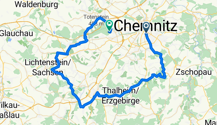
Route template
Chemnitz to Limbach-Oberfrohna

- 1 h 16 min
- Duration
- 21.7 km
- Distance
- 163 m
- Ascent
- 105 m
- Descent
- 17 km/h
- Avg. speed
- 388 m
- Max. altitude
This scenic route takes you from the vibrant city of Chemnitz to the laid-back town of Limbach-Oberfrohna—a perfect ride for those who enjoy mostly quiet roads and gentle countryside. You’ll cover just under 22 kilometers, cruising along good-quality pavement for almost the entire journey. Expect a fun mix of cycleways and calm back roads, so you can really relax and soak in the landscape.
Starting in Chemnitz, known for its modern art scene and cool industrial vibe, you’ll head northwest, gradually leaving the hustle behind for more tranquil settings. The route has a gentle ascent—nothing too punishing—making it accessible for most riders. Along the way, you might glimpse rolling fields and charming Saxon villages.
You wrap things up in Limbach-Oberfrohna, a smaller town that’s big on history and green spaces. It’s a great spot to grab a cold drink or explore the town’s laid-back parks before heading back or catching the train. All in all, it’s an approachable, scenic ride with just enough hills to keep things interesting.
Community
Top users in this region


From our community
The best bike routes from Chemnitz to Limbach-Oberfrohna


TU - Stausee Oberrabenstein
Cycling route in Chemnitz, Saxony, Germany
- 12.3 km
- Distance
- 149 m
- Ascent
- 83 m
- Descent
Donnerstag 20.07.17
Cycling route in Chemnitz, Saxony, Germany
- 72.1 km
- Distance
- 563 m
- Ascent
- 525 m
- Descent

von Reichenhain zum Totenstein (und zurück)
Cycling route in Chemnitz, Saxony, Germany
- 16.4 km
- Distance
- 212 m
- Ascent
- 95 m
- Descent

Chemnitz - Stausee Oberrabenstein
Cycling route in Chemnitz, Saxony, Germany
- 10.5 km
- Distance
- 128 m
- Ascent
- 31 m
- Descent

Michaelstraße 66, Хемниц до S 243, Limbach-Oberfrohna
Cycling route in Chemnitz, Saxony, Germany
- 11.5 km
- Distance
- 107 m
- Ascent
- 67 m
- Descent


Erz Runde
Cycling route in Chemnitz, Saxony, Germany
- 65.8 km
- Distance
- 991 m
- Ascent
- 913 m
- Descent


Discover more routes
 Chemnitz - Stausee Oberrabenstein
- Distance
- 10.5 km
- Ascent
- 128 m
- Descent
- 31 m
- Location
- Chemnitz, Saxony, Germany
 Michaelstraße 66, Хемниц до S 243, Limbach-Oberfrohna
- Distance
- 11.5 km
- Ascent
- 107 m
- Descent
- 67 m
- Location
- Chemnitz, Saxony, Germany
 21-04_2019
- Distance
- 165.7 km
- Ascent
- 1,367 m
- Descent
- 1,312 m
- Location
- Chemnitz, Saxony, Germany
 Erz Runde
- Distance
- 65.8 km
- Ascent
- 991 m
- Descent
- 913 m
- Location
- Chemnitz, Saxony, Germany
 Heimfahrt mit Umweg
- Distance
- 33.1 km
- Ascent
- 165 m
- Descent
- 123 m
- Location
- Chemnitz, Saxony, Germany
 Totenstein
- Distance
- 9.2 km
- Ascent
- 142 m
- Descent
- 22 m
- Location
- Chemnitz, Saxony, Germany
 ERZ-Runde
- Distance
- 64.4 km
- Ascent
- 837 m
- Descent
- 773 m
- Location
- Chemnitz, Saxony, Germany
 Biehlerstrecke
- Distance
- 19.7 km
- Ascent
- 337 m
- Descent
- 189 m
- Location
- Chemnitz, Saxony, Germany
Routes from Chemnitz
Cycling day trip from
Chemnitz to Leipzig
Cycling day trip from
Chemnitz to Dresden
Quick ride by bicycle from
Chemnitz to Neukirchen
Quick ride by bicycle from
Chemnitz to Wittgensdorf