
Cycling day trip from Saint-Jean-de-Maurienne to Valloire
Customize your own route based on our template or discover how our community prefers to cycle from Saint-Jean-de-Maurienne to Valloire.
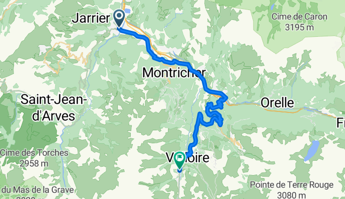
Route template
Saint-Jean-de-Maurienne to Valloire

- 4 h 26 min
- Duration
- 34.1 km
- Distance
- 2,420 m
- Ascent
- 1,543 m
- Descent
- 7.7 km/h
- Avg. speed
- 1,926 m
- Max. altitude
Ready for a classic Alpine adventure? This route kicks off in the charming town of Saint-Jean-de-Maurienne, famous as a regular highlight in the Tour de France and known as the “Gateway to the Maurienne Valley.” As you head out, be prepared for some serious climbing—the ride is only about 34 km, but don’t let the distance fool you! You’ll be tackling over 2400 meters of ascent. This means legs (and lungs) will get a real workout as you wind your way up through a mix of quiet roads, mountain tracks, and scenic paths. Surfaces are a bit varied—expect mostly missing data, but with some nice stretches of asphalt and a little gravel to keep things interesting.
The high point of your ride comes at a breathtaking 1926 meters above sea level—so pack a windbreaker! After cresting the climb, enjoy a well-earned descent down toward Valloire, a popular ski village nestled on the slopes of the Galibier, where you can grab a coffee and take in the mountain views. Perfect for strong riders seeking a true alpine experience!
Community
Top users in this region


From our community
The best bike routes from Saint-Jean-de-Maurienne to Valloire

Col du Telegraphe-Col du Galibier
Cycling route in Saint-Jean-de-Maurienne, Auvergne-Rhône-Alpes, France
- 49.3 km
- Distance
- 2,263 m
- Ascent
- 212 m
- Descent

Tel-Galiber
Cycling route in Saint-Jean-de-Maurienne, Auvergne-Rhône-Alpes, France
- 77.8 km
- Distance
- 2,544 m
- Ascent
- 1,568 m
- Descent

Col du Telegraphe-Col du Galibier
Cycling route in Saint-Jean-de-Maurienne, Auvergne-Rhône-Alpes, France
- 51.3 km
- Distance
- 2,404 m
- Ascent
- 295 m
- Descent

FR Saint-Jean-de-Maurienne - über den Col du Télégraphe zum Galibier
Cycling route in Saint-Jean-de-Maurienne, Auvergne-Rhône-Alpes, France
- 48.6 km
- Distance
- 2,214 m
- Ascent
- 208 m
- Descent

Etappe 2: Colde la Croix de Fer, Alpe d' huez, Les Deux Alpes, Col du Lautaret, Col de Galibier
Cycling route in Saint-Jean-de-Maurienne, Auvergne-Rhône-Alpes, France
- 176 km
- Distance
- 4,878 m
- Ascent
- 4,037 m
- Descent

rit 7:camping col de la croix de fer - col de telegraphe- valloire
Cycling route in Saint-Jean-de-Maurienne, Auvergne-Rhône-Alpes, France
- 53 km
- Distance
- 1,693 m
- Ascent
- 1,935 m
- Descent

camping naar Galibier
Cycling route in Saint-Jean-de-Maurienne, Auvergne-Rhône-Alpes, France
- 52.7 km
- Distance
- 2,332 m
- Ascent
- 344 m
- Descent

St Jean de Maurienne - Télégraphe - Col du Galibier
Cycling route in Saint-Jean-de-Maurienne, Auvergne-Rhône-Alpes, France
- 47.5 km
- Distance
- 2,285 m
- Ascent
- 200 m
- Descent

Lørdag 6/7-19, Telegraphe+Calibier
Cycling route in Saint-Jean-de-Maurienne, Auvergne-Rhône-Alpes, France
- 47.3 km
- Distance
- 2,265 m
- Ascent
- 170 m
- Descent
Saint-Jean-de-Maurienne - Valloire
Cycling route in Saint-Jean-de-Maurienne, Auvergne-Rhône-Alpes, France
- 32.4 km
- Distance
- 1,549 m
- Ascent
- 607 m
- Descent

montagne
Cycling route in Saint-Jean-de-Maurienne, Auvergne-Rhône-Alpes, France
- 63.1 km
- Distance
- 2,571 m
- Ascent
- 464 m
- Descent

St Jean de Maurienne Galibier
Cycling route in Saint-Jean-de-Maurienne, Auvergne-Rhône-Alpes, France
- 44.3 km
- Distance
- 2,207 m
- Ascent
- 212 m
- Descent
Discover more routes
 Etappe 2: Colde la Croix de Fer, Alpe d' huez, Les Deux Alpes, Col du Lautaret, Col de Galibier
- Distance
- 176 km
- Ascent
- 4,878 m
- Descent
- 4,037 m
- Location
- Saint-Jean-de-Maurienne, Auvergne-Rhône-Alpes, France
 rit 7:camping col de la croix de fer - col de telegraphe- valloire
- Distance
- 53 km
- Ascent
- 1,693 m
- Descent
- 1,935 m
- Location
- Saint-Jean-de-Maurienne, Auvergne-Rhône-Alpes, France
 camping naar Galibier
- Distance
- 52.7 km
- Ascent
- 2,332 m
- Descent
- 344 m
- Location
- Saint-Jean-de-Maurienne, Auvergne-Rhône-Alpes, France
 St Jean de Maurienne - Télégraphe - Col du Galibier
- Distance
- 47.5 km
- Ascent
- 2,285 m
- Descent
- 200 m
- Location
- Saint-Jean-de-Maurienne, Auvergne-Rhône-Alpes, France
 Lørdag 6/7-19, Telegraphe+Calibier
- Distance
- 47.3 km
- Ascent
- 2,265 m
- Descent
- 170 m
- Location
- Saint-Jean-de-Maurienne, Auvergne-Rhône-Alpes, France
 Saint-Jean-de-Maurienne - Valloire
- Distance
- 32.4 km
- Ascent
- 1,549 m
- Descent
- 607 m
- Location
- Saint-Jean-de-Maurienne, Auvergne-Rhône-Alpes, France
 montagne
- Distance
- 63.1 km
- Ascent
- 2,571 m
- Descent
- 464 m
- Location
- Saint-Jean-de-Maurienne, Auvergne-Rhône-Alpes, France
 St Jean de Maurienne Galibier
- Distance
- 44.3 km
- Ascent
- 2,207 m
- Descent
- 212 m
- Location
- Saint-Jean-de-Maurienne, Auvergne-Rhône-Alpes, France
Routes from Saint-Jean-de-Maurienne
Cycling day trip from
Saint-Jean-de-Maurienne to Huez
Cycling day trip from
Saint-Jean-de-Maurienne to Briançon
Routes to Valloire
Bikepacking from
Val d'Isère to Valloire
Cycling day trip from
Briançon to Valloire
Cycling day trip from
Huez to Valloire
Quick ride by bicycle from
Saint-Michel-de-Maurienne to Valloire