
Cycling day trip from Saint-Jean-de-Maurienne to Huez
Customize your own route based on our template or discover how our community prefers to cycle from Saint-Jean-de-Maurienne to Huez.
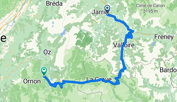
Route template
Saint-Jean-de-Maurienne to Huez

- 8 h 48 min
- Duration
- 61.5 km
- Distance
- 3,733 m
- Ascent
- 2,763 m
- Descent
- 7 km/h
- Avg. speed
- 2,469 m
- Max. altitude
Ready for a legendary ride? This route rolls out from Saint-Jean-de-Maurienne, known as a classic launchpad for epic climbs in the heart of the French Alps. You’ll cover just over 61 km, but with almost 3,800 meters of climbing, this is no casual spin—it’s one for the bucket list.
You’ll pass through dramatic mountain scenery and take on a mix of quiet roads, tracks, and iconic paths. Most of the surface is missing or variable, so expect some adventure off the perfect tarmac! Keep in mind that some stretches are pretty isolated and demanding.
The highlight? Approaching Huez, home to the famous Alpe d’Huez climb, with its legendary hairpins and Tour de France history. At max elevation, you’ll top out around 2,470 meters—so prepare for changing weather and cool air! Wrap up at Huez and reward yourself with stunning panoramic views and the satisfaction of conquering one of cycling’s iconic playgrounds.
Community
Top users in this region


From our community
The best bike routes from Saint-Jean-de-Maurienne to Huez

Transalpine (13) St. Jean de Maurienne - Allemond
Cycling route in Saint-Jean-de-Maurienne, Auvergne-Rhône-Alpes, France
- 70.3 km
- Distance
- 2,128 m
- Ascent
- 1,953 m
- Descent

Rohne-Alpes: Etappe 3
Cycling route in Saint-Jean-de-Maurienne, Auvergne-Rhône-Alpes, France
- 69.5 km
- Distance
- 2,031 m
- Ascent
- 1,732 m
- Descent

TDF 17 Saint Jean de Maurienne - L'Alpe d' Huez
Cycling route in Saint-Jean-de-Maurienne, Auvergne-Rhône-Alpes, France
- 109 km
- Distance
- 3,583 m
- Ascent
- 2,304 m
- Descent

5 La Toussouire - L'Alpe d'Huez Vol. 2
Cycling route in Saint-Jean-de-Maurienne, Auvergne-Rhône-Alpes, France
- 89.7 km
- Distance
- 2,432 m
- Ascent
- 2,289 m
- Descent

ALP-3 ST.JEAN - LE BOURG
Cycling route in Saint-Jean-de-Maurienne, Auvergne-Rhône-Alpes, France
- 125.7 km
- Distance
- 3,567 m
- Ascent
- 3,413 m
- Descent

3. St. Jean de Maurienne - Col de la Croix de Fer - L'Alpe d'Huez - Le Bourg-d’Oisan
Cycling route in Saint-Jean-de-Maurienne, Auvergne-Rhône-Alpes, France
- 98.2 km
- Distance
- 3,781 m
- Ascent
- 3,629 m
- Descent

016 St.Jean-de-Maurienne - Allemont
Cycling route in Saint-Jean-de-Maurienne, Auvergne-Rhône-Alpes, France
- 71.5 km
- Distance
- 2,002 m
- Ascent
- 1,825 m
- Descent

Day 3 - St JDM Télégraphe-Galibier-Borg D'Oisans
Cycling route in Saint-Jean-de-Maurienne, Auvergne-Rhône-Alpes, France
- 96.3 km
- Distance
- 2,536 m
- Ascent
- 2,383 m
- Descent

Alpes 2017 - 4/7
Cycling route in Saint-Jean-de-Maurienne, Auvergne-Rhône-Alpes, France
- 128 km
- Distance
- 3,366 m
- Ascent
- 3,226 m
- Descent

Routes Alpes 2
Cycling route in Saint-Jean-de-Maurienne, Auvergne-Rhône-Alpes, France
- 78.3 km
- Distance
- 2,448 m
- Ascent
- 1,842 m
- Descent
St. Jean de Maurienne - Telegraph - Galibier - Lautaret - Deux Alpes - Bourg d'oisans
Cycling route in Saint-Jean-de-Maurienne, Auvergne-Rhône-Alpes, France
- 105.4 km
- Distance
- 2,699 m
- Ascent
- 2,547 m
- Descent

alpe duez
Cycling route in Saint-Jean-de-Maurienne, Auvergne-Rhône-Alpes, France
- 85.6 km
- Distance
- 2,599 m
- Ascent
- 1,337 m
- Descent
Discover more routes
 ALP-3 ST.JEAN - LE BOURG
- Distance
- 125.7 km
- Ascent
- 3,567 m
- Descent
- 3,413 m
- Location
- Saint-Jean-de-Maurienne, Auvergne-Rhône-Alpes, France
 3. St. Jean de Maurienne - Col de la Croix de Fer - L'Alpe d'Huez - Le Bourg-d’Oisan
- Distance
- 98.2 km
- Ascent
- 3,781 m
- Descent
- 3,629 m
- Location
- Saint-Jean-de-Maurienne, Auvergne-Rhône-Alpes, France
 016 St.Jean-de-Maurienne - Allemont
- Distance
- 71.5 km
- Ascent
- 2,002 m
- Descent
- 1,825 m
- Location
- Saint-Jean-de-Maurienne, Auvergne-Rhône-Alpes, France
 Day 3 - St JDM Télégraphe-Galibier-Borg D'Oisans
- Distance
- 96.3 km
- Ascent
- 2,536 m
- Descent
- 2,383 m
- Location
- Saint-Jean-de-Maurienne, Auvergne-Rhône-Alpes, France
 Alpes 2017 - 4/7
- Distance
- 128 km
- Ascent
- 3,366 m
- Descent
- 3,226 m
- Location
- Saint-Jean-de-Maurienne, Auvergne-Rhône-Alpes, France
 Routes Alpes 2
- Distance
- 78.3 km
- Ascent
- 2,448 m
- Descent
- 1,842 m
- Location
- Saint-Jean-de-Maurienne, Auvergne-Rhône-Alpes, France
 St. Jean de Maurienne - Telegraph - Galibier - Lautaret - Deux Alpes - Bourg d'oisans
- Distance
- 105.4 km
- Ascent
- 2,699 m
- Descent
- 2,547 m
- Location
- Saint-Jean-de-Maurienne, Auvergne-Rhône-Alpes, France
 alpe duez
- Distance
- 85.6 km
- Ascent
- 2,599 m
- Descent
- 1,337 m
- Location
- Saint-Jean-de-Maurienne, Auvergne-Rhône-Alpes, France
Routes from Saint-Jean-de-Maurienne
Cycling day trip from
Saint-Jean-de-Maurienne to Valloire
Cycling day trip from
Saint-Jean-de-Maurienne to Briançon
Routes to Huez
Cycling day trip from
Briançon to Huez
Cycling day trip from
Modane to Huez