

Cycling day trip from Quillan to Ax-les-Thermes
Customize your own route based on our template or discover how our community prefers to cycle from Quillan to Ax-les-Thermes.
Route template
Quillan to Ax-les-Thermes
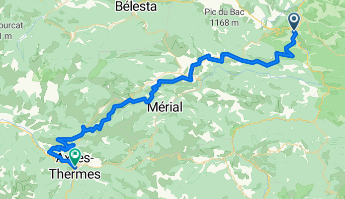
This adventurous ride takes you from Quillan, a charming small town nestled along the River Aude in the foothills of the Pyrenees, to the spa town of Ax-les-Thermes, famous for its thermal springs and bubbling rivers. Covering just over 65 km, expect plenty of fresh mountain airâalong with a seriously impressive ascent of more than 2,700 meters!
The route is a true test for gravel grinders and mountain bikers: about half of it is unpaved or gravel, winding mostly along scenic tracks through wild Pyrenean landscapes. Thereâll be some stretches on quiet roads, but this is one for lovers of the backcountry, not tarmac devotees. Expect panoramic views, big climbs, and exhilarating descents, topping out at around 1,550 meters above sea level.
Wrap up in Ax-les-Thermes by soaking your legs in one of the hot pools in the center of townâa tradition for weary travelers for centuries! Make sure to bring snacks, your sense of adventure, and a camera.
Community
Top users in this region
From our community
The best bike routes from Quillan to Ax-les-Thermes
RZ d1
Cycling route in Quillan, Occitanie, France
- 54.6 km
- Distance
- 1,622 m
- Ascent
- 1,353 m
- Descent
Axat - Ax Les Thermes
Cycling route in Quillan, Occitanie, France
- 53.7 km
- Distance
- 1,713 m
- Ascent
- 1,447 m
- Descent
Carcanieres - Ascou (Pailheres)
Cycling route in Quillan, Occitanie, France
- 30.8 km
- Distance
- 949 m
- Ascent
- 1,048 m
- Descent
PAILHĂRES, por Mijanès
Cycling route in Quillan, Occitanie, France
- 15.7 km
- Distance
- 1,239 m
- Ascent
- 62 m
- Descent
Quillan to Ax Les Thermes
Cycling route in Quillan, Occitanie, France
- 57 km
- Distance
- 1,657 m
- Ascent
- 1,221 m
- Descent
Pyrenäen 2. Etappe Alternative
Cycling route in Quillan, Occitanie, France
- 64.7 km
- Distance
- 1,893 m
- Ascent
- 1,894 m
- Descent
Etapa 4 Axat-Laforge Goulours
Cycling route in Quillan, Occitanie, France
- 53.9 km
- Distance
- 1,714 m
- Ascent
- 1,018 m
- Descent
Alternative 2.1
Cycling route in Quillan, Occitanie, France
- 102.3 km
- Distance
- 2,385 m
- Ascent
- 1,962 m
- Descent
pailheres
Cycling route in Quillan, Occitanie, France
- 31.6 km
- Distance
- 1,216 m
- Ascent
- 1,068 m
- Descent
Discover more routes
- Quillan to Ax Les Thermes
- Distance
- 57 km
- Ascent
- 1,657 m
- Descent
- 1,221 m
- Location
- Quillan, Occitanie, France
- Pyrenäen 2. Etappe Alternative
- Distance
- 64.7 km
- Ascent
- 1,893 m
- Descent
- 1,894 m
- Location
- Quillan, Occitanie, France
- Etapa 4 Axat-Laforge Goulours
- Distance
- 53.9 km
- Ascent
- 1,714 m
- Descent
- 1,018 m
- Location
- Quillan, Occitanie, France
- AXAT
- Distance
- 37.7 km
- Ascent
- 1,792 m
- Descent
- 246 m
- Location
- Quillan, Occitanie, France
- Col de Pailheres
- Distance
- 35.2 km
- Ascent
- 1,671 m
- Descent
- 104 m
- Location
- Quillan, Occitanie, France
- Alternative 2.1
- Distance
- 102.3 km
- Ascent
- 2,385 m
- Descent
- 1,962 m
- Location
- Quillan, Occitanie, France
- pailheres
- Distance
- 31.6 km
- Ascent
- 1,216 m
- Descent
- 1,068 m
- Location
- Quillan, Occitanie, France
- 2013 8
- Distance
- 79.5 km
- Ascent
- 2,752 m
- Descent
- 1,674 m
- Location
- Quillan, Occitanie, France
Routes to Ax-les-Thermes
Cycling day trip from
Saint-Girons to Ax-les-Thermes
Cycling day trip from
Tarascon-sur-Ariège to Ax-les-Thermes