
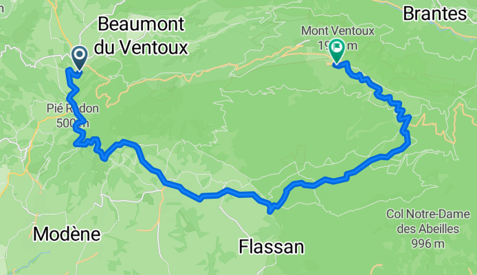
Route template
Malaucène to Bédoin

- 1 h 20 min
- Duration
- 18.9 km
- Distance
- 433 m
- Ascent
- 463 m
- Descent
- 14.2 km/h
- Avg. speed
- 407 m
- Max. altitude
This ride takes you from Malaucène to Bédoin, two charming villages nestled at the foot of Mont Ventoux—famous among cyclists as the “Giant of Provence.” Starting in Malaucène, you’ll spin out over nearly 19 kilometers mainly along quiet roads with hardly any busy traffic. The route features a good mix of gentle climbs and rewarding descents (you’ll climb over 430 meters and drop about 460 meters!), so be ready for a bit of up and down.
Expect a mostly paved and asphalt surface, making for a smooth and enjoyable ride. Both Malaucène and Bédoin are popular starting points for conquering Mont Ventoux, but this route lets you enjoy the scenery and Provençal atmosphere without the brutal climb. You’ll pass through vineyards, wild scrubland, and rolling hills on tranquil country roads—just soak up those classic southern French vibes.
Bédoin, the finish, is a classic cyclists’ haunt with plenty of cafés for a post-ride coffee and maybe a pastry. Enjoy the ride and take your time—it’s Provence, after all!
Community
Top users in this region


From our community
The best bike routes from Malaucène to Bédoin

Malaucene-Bedoin
Cycling route in Malaucène, Provence-Alpes-Côte d'Azur Region, France
- 32.6 km
- Distance
- 436 m
- Ascent
- 423 m
- Descent

M - Mont Ventoux
Cycling route in Malaucène, Provence-Alpes-Côte d'Azur Region, France
- 21.9 km
- Distance
- 1,618 m
- Ascent
- 54 m
- Descent

Huis - bedoin -Mt Ventoux
Cycling route in Malaucène, Provence-Alpes-Côte d'Azur Region, France
- 38.4 km
- Distance
- 1,846 m
- Ascent
- 218 m
- Descent

Malaucene -> Mont Ventoux par Bedoin X Caviar
Cycling route in Malaucène, Provence-Alpes-Côte d'Azur Region, France
- 33.6 km
- Distance
- 1,780 m
- Ascent
- 216 m
- Descent

Malaucène - Mont Ventoux
Cycling route in Malaucène, Provence-Alpes-Côte d'Azur Region, France
- 22.3 km
- Distance
- 1,549 m
- Ascent
- 62 m
- Descent

VNS 2015
Cycling route in Malaucène, Provence-Alpes-Côte d'Azur Region, France
- 22.5 km
- Distance
- 1,611 m
- Ascent
- 46 m
- Descent

M - Mont Ventoux
Cycling route in Malaucène, Provence-Alpes-Côte d'Azur Region, France
- 21.9 km
- Distance
- 1,597 m
- Ascent
- 38 m
- Descent

Malaucene-MontVentaux
Cycling route in Malaucène, Provence-Alpes-Côte d'Azur Region, France
- 21.2 km
- Distance
- 1,597 m
- Ascent
- 26 m
- Descent

2 Malaucene Bedoin
Cycling route in Malaucène, Provence-Alpes-Côte d'Azur Region, France
- 11.2 km
- Distance
- 196 m
- Ascent
- 219 m
- Descent

Mont ventoux Malaucene
Cycling route in Malaucène, Provence-Alpes-Côte d'Azur Region, France
- 20.9 km
- Distance
- 1,569 m
- Ascent
- 15 m
- Descent

Montventoux vanuit Malaucène
Cycling route in Malaucène, Provence-Alpes-Côte d'Azur Region, France
- 21 km
- Distance
- 1,568 m
- Ascent
- 8 m
- Descent
2012-12: Malaucène > Mont Ventoux (33km - ITT)
Cycling route in Malaucène, Provence-Alpes-Côte d'Azur Region, France
- 33 km
- Distance
- 1,616 m
- Ascent
- 468 m
- Descent
Discover more routes
 Malaucène - Mont Ventoux
- Distance
- 22.3 km
- Ascent
- 1,549 m
- Descent
- 62 m
- Location
- Malaucène, Provence-Alpes-Côte d'Azur Region, France
 VNS 2015
- Distance
- 22.5 km
- Ascent
- 1,611 m
- Descent
- 46 m
- Location
- Malaucène, Provence-Alpes-Côte d'Azur Region, France
 M - Mont Ventoux
- Distance
- 21.9 km
- Ascent
- 1,597 m
- Descent
- 38 m
- Location
- Malaucène, Provence-Alpes-Côte d'Azur Region, France
 Malaucene-MontVentaux
- Distance
- 21.2 km
- Ascent
- 1,597 m
- Descent
- 26 m
- Location
- Malaucène, Provence-Alpes-Côte d'Azur Region, France
 2 Malaucene Bedoin
- Distance
- 11.2 km
- Ascent
- 196 m
- Descent
- 219 m
- Location
- Malaucène, Provence-Alpes-Côte d'Azur Region, France
 Mont ventoux Malaucene
- Distance
- 20.9 km
- Ascent
- 1,569 m
- Descent
- 15 m
- Location
- Malaucène, Provence-Alpes-Côte d'Azur Region, France
 Montventoux vanuit Malaucène
- Distance
- 21 km
- Ascent
- 1,568 m
- Descent
- 8 m
- Location
- Malaucène, Provence-Alpes-Côte d'Azur Region, France
 2012-12: Malaucène > Mont Ventoux (33km - ITT)
- Distance
- 33 km
- Ascent
- 1,616 m
- Descent
- 468 m
- Location
- Malaucène, Provence-Alpes-Côte d'Azur Region, France
Routes to Bédoin
Cycling day trip from
Avignon to Bédoin
Cycling day trip from
Sault to Bédoin