
Cycling day trip from Luz-Saint-Sauveur to Campan
Customize your own route based on our template or discover how our community prefers to cycle from Luz-Saint-Sauveur to Campan.
Route template
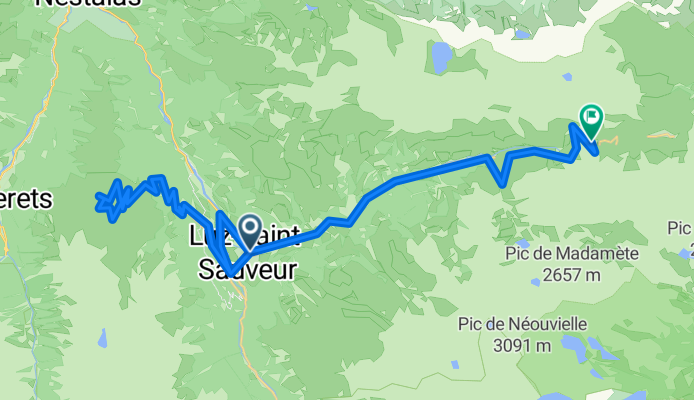
Luz-Saint-Sauveur to Campan

- 8 h 28 min
- Duration
- 94 km
- Distance
- 3,821 m
- Ascent
- 3,872 m
- Descent
- 11.1 km/h
- Avg. speed
- 1,946 m
- Max. altitude
Get ready for a true Pyrenean adventure! This ride starts in Luz-Saint-Sauveur, a charming mountain town known as a gateway to the legendary Tourmalet pass and the stunning Gavarnie Cirque. You’ll be cycling over 93 km of spectacular high-altitude terrain to the peaceful village of Campan, famous for its traditional “mounaques” dolls and proximity to the Pic du Midi.
The route serves up a hefty 3,800 m of climbing, so it’s a serious challenge—but the descending matches the ascent for some thrilling downhills. Expect a mix of riding surfaces, with about half the journey on less documented track (be ready for adventure!), a fair share of smooth asphalt, and a splash of gravel and ground to keep things interesting.
You’ll spend most of your time on quiet roads, scenic paths, and the occasional classic French cycleway, with very little traffic. Take your time to enjoy the epic Pyrenean vistas, maybe snap a photo at the Col du Tourmalet if you pass by, and look out for sheep grazing on the high meadows!
Finish your ride in Campan, where rustic charm and a cold drink await.
Community
Top users in this region


From our community
The best bike routes from Luz-Saint-Sauveur to Campan

TDP - ETAPE 6
Cycling route in Luz-Saint-Sauveur, Occitanie, France
- 58.9 km
- Distance
- 2,527 m
- Ascent
- 2,273 m
- Descent

V12 Col du Tourmalet
Cycling route in Luz-Saint-Sauveur, Occitanie, France
- 30.7 km
- Distance
- 2,213 m
- Ascent
- 349 m
- Descent

2010_Col du Tourmalet (2115 m)
Cycling route in Luz-Saint-Sauveur, Occitanie, France
- 18.3 km
- Distance
- 1,588 m
- Ascent
- 191 m
- Descent
DEFICAP 2015
Cycling route in Luz-Saint-Sauveur, Occitanie, France
- 53.7 km
- Distance
- 2,743 m
- Ascent
- 1,314 m
- Descent

Lac Cap-de-Long Alt 2150m à Campan
Cycling route in Luz-Saint-Sauveur, Occitanie, France
- 65.9 km
- Distance
- 867 m
- Ascent
- 2,335 m
- Descent

Pic du Midi de Bigorre
Cycling route in Luz-Saint-Sauveur, Occitanie, France
- 24.9 km
- Distance
- 2,114 m
- Ascent
- 7 m
- Descent

TDF Fake 18
Cycling route in Luz-Saint-Sauveur, Occitanie, France
- 22.4 km
- Distance
- 1,500 m
- Ascent
- 488 m
- Descent

TOURMALET
Cycling route in Luz-Saint-Sauveur, Occitanie, France
- 18.4 km
- Distance
- 1,407 m
- Ascent
- 8 m
- Descent

luz st sauveur / luz ardiden / luz st sauveur / Tourmalet
Cycling route in Luz-Saint-Sauveur, Occitanie, France
- 56.5 km
- Distance
- 2,748 m
- Ascent
- 1,336 m
- Descent

Homerun_Col_de_Tourmalet
Cycling route in Luz-Saint-Sauveur, Occitanie, France
- 17.8 km
- Distance
- 1,491 m
- Ascent
- 110 m
- Descent
Tourmalet
Cycling route in Luz-Saint-Sauveur, Occitanie, France
- 19.1 km
- Distance
- 1,406 m
- Ascent
- 5 m
- Descent

De 20 Place du 8 Mai 1945, Luz-Saint-Sauveur à D918, Bagnères-de-Bigorre
Cycling route in Luz-Saint-Sauveur, Occitanie, France
- 18.3 km
- Distance
- 1,418 m
- Ascent
- 14 m
- Descent
Discover more routes
 Lac Cap-de-Long Alt 2150m à Campan
- Distance
- 65.9 km
- Ascent
- 867 m
- Descent
- 2,335 m
- Location
- Luz-Saint-Sauveur, Occitanie, France
 Pic du Midi de Bigorre
- Distance
- 24.9 km
- Ascent
- 2,114 m
- Descent
- 7 m
- Location
- Luz-Saint-Sauveur, Occitanie, France
 TDF Fake 18
- Distance
- 22.4 km
- Ascent
- 1,500 m
- Descent
- 488 m
- Location
- Luz-Saint-Sauveur, Occitanie, France
 TOURMALET
- Distance
- 18.4 km
- Ascent
- 1,407 m
- Descent
- 8 m
- Location
- Luz-Saint-Sauveur, Occitanie, France
 luz st sauveur / luz ardiden / luz st sauveur / Tourmalet
- Distance
- 56.5 km
- Ascent
- 2,748 m
- Descent
- 1,336 m
- Location
- Luz-Saint-Sauveur, Occitanie, France
 Homerun_Col_de_Tourmalet
- Distance
- 17.8 km
- Ascent
- 1,491 m
- Descent
- 110 m
- Location
- Luz-Saint-Sauveur, Occitanie, France
 Tourmalet
- Distance
- 19.1 km
- Ascent
- 1,406 m
- Descent
- 5 m
- Location
- Luz-Saint-Sauveur, Occitanie, France
 De 20 Place du 8 Mai 1945, Luz-Saint-Sauveur à D918, Bagnères-de-Bigorre
- Distance
- 18.3 km
- Ascent
- 1,418 m
- Descent
- 14 m
- Location
- Luz-Saint-Sauveur, Occitanie, France
Routes from Luz-Saint-Sauveur
Cycling day trip from
Luz-Saint-Sauveur to Cauterets
Cycling day trip from
Luz-Saint-Sauveur to Saint-Lary-Soulan
Routes to Campan
Cycling day trip from
Bagnères-de-Luchon to Campan
Cycling day trip from
Saint-Lary-Soulan to Campan