
Cycling day trip from Le Monêtier-les-Bains to Valloire
Customize your own route based on our template or discover how our community prefers to cycle from Le Monêtier-les-Bains to Valloire.
Route template
Le Monêtier-les-Bains to Valloire

- 3 h 38 min
- Duration
- 39.7 km
- Distance
- 1,325 m
- Ascent
- 1,396 m
- Descent
- 10.9 km/h
- Avg. speed
- 2,634 m
- Max. altitude
Le Monêtier-les-Bains to Valloire: A Classic Alpine Ride
Get ready for a big day in the saddle! This route takes you from the thermal spa town of Le Monêtier-les-Bains, nestled in the Serre Chevalier valley, all the way to Valloire—a charming alpine resort with classic mountain vibes.
You’ll climb over 1300 meters (that’s a lot of uphill!) with the high point nudging 2634 meters, meaning you’ll likely cross the legendary Col du Galibier—one of the Tour de France’s most iconic passes. The views are breathtaking, and don’t be surprised if you spot a few marmots along the way!
The surfaces are mostly paved or asphalt, but be ready for some gravel and a handful of unpaved sections—adventure tires recommended. The roads switch between busier main routes and peaceful tracks, so stay alert, especially on the descents into Valloire.
After almost 40 kilometers, you’ll roll into Valloire, famous for its cheese, ski slopes, and delightful mountain charm. Treat yourself to a hearty Savoyard meal—you’ll have earned it!
Community
Top users in this region


From our community
The best bike routes from Le Monêtier-les-Bains to Valloire

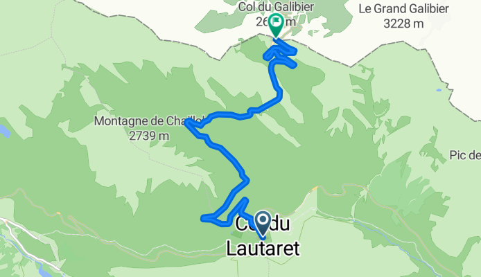
Le Col du Galibier, depuis le Lautaret
Cycling route in Le Monêtier-les-Bains, Provence-Alpes-Côte d'Azur Region, France
- 8.7 km
- Distance
- 592 m
- Ascent
- 5 m
- Descent

Etape 1
Cycling route in Le Monêtier-les-Bains, Provence-Alpes-Côte d'Azur Region, France
- 9.9 km
- Distance
- 746 m
- Ascent
- 118 m
- Descent

Galibier 21km
Cycling route in Le Monêtier-les-Bains, Provence-Alpes-Côte d'Azur Region, France
- 21.5 km
- Distance
- 1,134 m
- Ascent
- 0 m
- Descent

Galibier
Cycling route in Le Monêtier-les-Bains, Provence-Alpes-Côte d'Azur Region, France
- 22 km
- Distance
- 1,138 m
- Ascent
- 0 m
- Descent

J2 Ponsonniere
Cycling route in Le Monêtier-les-Bains, Provence-Alpes-Côte d'Azur Region, France
- 12.6 km
- Distance
- 792 m
- Ascent
- 608 m
- Descent
Galibier
Cycling route in Le Monêtier-les-Bains, Provence-Alpes-Côte d'Azur Region, France
- 8.7 km
- Distance
- 577 m
- Ascent
- 9 m
- Descent

Re magi la drayeres 26 1700
Cycling route in Le Monêtier-les-Bains, Provence-Alpes-Côte d'Azur Region, France
- 26 km
- Distance
- 1,617 m
- Ascent
- 1,230 m
- Descent

Col du Galibrier (vanuit Lautaret)
Cycling route in Le Monêtier-les-Bains, Provence-Alpes-Côte d'Azur Region, France
- 9.7 km
- Distance
- 604 m
- Ascent
- 112 m
- Descent

BZF Col du Galibier
Cycling route in Le Monêtier-les-Bains, Provence-Alpes-Côte d'Azur Region, France
- 4.3 km
- Distance
- 303 m
- Ascent
- 31 m
- Descent

kkkkkkkk jjhjjh
Cycling route in Le Monêtier-les-Bains, Provence-Alpes-Côte d'Azur Region, France
- 8.6 km
- Distance
- 11 m
- Ascent
- 491 m
- Descent

Etappe12 - Französische Alpen
Cycling route in Le Monêtier-les-Bains, Provence-Alpes-Côte d'Azur Region, France
- 39.9 km
- Distance
- 1,128 m
- Ascent
- 1,223 m
- Descent
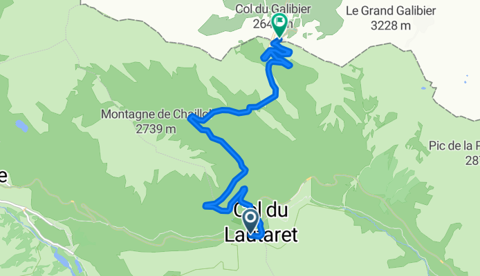
Col de Lautaret - Col du Galibier
Cycling route in Le Monêtier-les-Bains, Provence-Alpes-Côte d'Azur Region, France
- 9 km
- Distance
- 771 m
- Ascent
- 156 m
- Descent
Discover more routes
 J2 Ponsonniere
- Distance
- 12.6 km
- Ascent
- 792 m
- Descent
- 608 m
- Location
- Le Monêtier-les-Bains, Provence-Alpes-Côte d'Azur Region, France
 Galibier
- Distance
- 8.7 km
- Ascent
- 577 m
- Descent
- 9 m
- Location
- Le Monêtier-les-Bains, Provence-Alpes-Côte d'Azur Region, France
 Re magi la drayeres 26 1700
- Distance
- 26 km
- Ascent
- 1,617 m
- Descent
- 1,230 m
- Location
- Le Monêtier-les-Bains, Provence-Alpes-Côte d'Azur Region, France
 Col du Galibrier (vanuit Lautaret)
- Distance
- 9.7 km
- Ascent
- 604 m
- Descent
- 112 m
- Location
- Le Monêtier-les-Bains, Provence-Alpes-Côte d'Azur Region, France
 BZF Col du Galibier
- Distance
- 4.3 km
- Ascent
- 303 m
- Descent
- 31 m
- Location
- Le Monêtier-les-Bains, Provence-Alpes-Côte d'Azur Region, France
 kkkkkkkk jjhjjh
- Distance
- 8.6 km
- Ascent
- 11 m
- Descent
- 491 m
- Location
- Le Monêtier-les-Bains, Provence-Alpes-Côte d'Azur Region, France
 Etappe12 - Französische Alpen
- Distance
- 39.9 km
- Ascent
- 1,128 m
- Descent
- 1,223 m
- Location
- Le Monêtier-les-Bains, Provence-Alpes-Côte d'Azur Region, France
 Col de Lautaret - Col du Galibier
- Distance
- 9 km
- Ascent
- 771 m
- Descent
- 156 m
- Location
- Le Monêtier-les-Bains, Provence-Alpes-Côte d'Azur Region, France
Routes from Le Monêtier-les-Bains
Cycling day trip from
Le Monêtier-les-Bains to Huez
Routes to Valloire
Bikepacking from
Val d'Isère to Valloire
Cycling day trip from
Briançon to Valloire
Cycling day trip from
Huez to Valloire
By bicycle from
Saint-Michel-de-Maurienne to Valloire