

Route template
Laruns to Campan
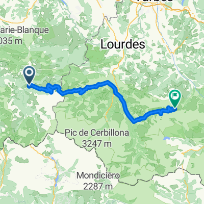
Ready for a true Pyrenean adventure? This route takes you from the charming mountain village of Laruns, nestled in the Vallée d’Ossau, to the peaceful Campan, a gateway to the famous Col du Tourmalet. Expect a real leg-burner: it’s about 101 km with a whopping 2,600 meters of climbing—classic high-mountain riding!
Much of the journey rolls along quiet roads with a mix of smooth asphalt and a few rustic, unpaved sections (perfect for a little gravel flavor). You’ll wind through dramatic valleys, pastures, and quaint hamlets, all the while surrounded by epic Pyrenean views. Both Laruns and Campan have strong cycling pedigrees—Campan especially, as many cyclists use it as a base to tackle the legendary cols nearby.
Bring snacks, layers, and your climbing legs, because this is a ride you’ll remember for both the challenge and the scenery. Don’t forget to stop and take it all in—summiting a Pyrenean col is always worth a selfie!
Community
Top users in this region
From our community
The best bike routes from Laruns to Campan
2012 T3
Cycling route in Laruns, Nouvelle-Aquitaine, France
- 107 km
- Distance
- 2,880 m
- Ascent
- 2,745 m
- Descent
Miticas Tour
Cycling route in Laruns, Nouvelle-Aquitaine, France
- 105.7 km
- Distance
- 3,909 m
- Ascent
- 2,830 m
- Descent
TransAlp 2016 - 2
Cycling route in Laruns, Nouvelle-Aquitaine, France
- 121.7 km
- Distance
- 2,838 m
- Ascent
- 2,515 m
- Descent
laruns tourmalet
Cycling route in Laruns, Nouvelle-Aquitaine, France
- 82.3 km
- Distance
- 2,973 m
- Ascent
- 1,604 m
- Descent
tyuio
Cycling route in Laruns, Nouvelle-Aquitaine, France
- 207.1 km
- Distance
- 7,205 m
- Ascent
- 4,940 m
- Descent
crasaf
Cycling route in Laruns, Nouvelle-Aquitaine, France
- 216.6 km
- Distance
- 5,845 m
- Ascent
- 3,602 m
- Descent
wfgh
Cycling route in Laruns, Nouvelle-Aquitaine, France
- 207.3 km
- Distance
- 7,274 m
- Ascent
- 4,984 m
- Descent
Eaux Bonnes - Campan (La Taniere des ours)
Cycling route in Laruns, Nouvelle-Aquitaine, France
- 96.3 km
- Distance
- 2,700 m
- Ascent
- 2,557 m
- Descent
sdfgh
Cycling route in Laruns, Nouvelle-Aquitaine, France
- 197 km
- Distance
- 6,798 m
- Ascent
- 4,537 m
- Descent
Eaux Chaudes-Campan. Mayo 2015.
Cycling route in Laruns, Nouvelle-Aquitaine, France
- 123.2 km
- Distance
- 1,548 m
- Ascent
- 1,553 m
- Descent
TRAV-3
Cycling route in Laruns, Nouvelle-Aquitaine, France
- 136.7 km
- Distance
- 3,647 m
- Ascent
- 2,949 m
- Descent
F-Parcours 2 Till
Cycling route in Laruns, Nouvelle-Aquitaine, France
- 97.8 km
- Distance
- 4,704 m
- Ascent
- 4,774 m
- Descent
Discover more routes
- tyuio
- Distance
- 207.1 km
- Ascent
- 7,205 m
- Descent
- 4,940 m
- Location
- Laruns, Nouvelle-Aquitaine, France
- crasaf
- Distance
- 216.6 km
- Ascent
- 5,845 m
- Descent
- 3,602 m
- Location
- Laruns, Nouvelle-Aquitaine, France
- wfgh
- Distance
- 207.3 km
- Ascent
- 7,274 m
- Descent
- 4,984 m
- Location
- Laruns, Nouvelle-Aquitaine, France
- Eaux Bonnes - Campan (La Taniere des ours)
- Distance
- 96.3 km
- Ascent
- 2,700 m
- Descent
- 2,557 m
- Location
- Laruns, Nouvelle-Aquitaine, France
- sdfgh
- Distance
- 197 km
- Ascent
- 6,798 m
- Descent
- 4,537 m
- Location
- Laruns, Nouvelle-Aquitaine, France
- Eaux Chaudes-Campan. Mayo 2015.
- Distance
- 123.2 km
- Ascent
- 1,548 m
- Descent
- 1,553 m
- Location
- Laruns, Nouvelle-Aquitaine, France
- TRAV-3
- Distance
- 136.7 km
- Ascent
- 3,647 m
- Descent
- 2,949 m
- Location
- Laruns, Nouvelle-Aquitaine, France
- F-Parcours 2 Till
- Distance
- 97.8 km
- Ascent
- 4,704 m
- Descent
- 4,774 m
- Location
- Laruns, Nouvelle-Aquitaine, France
Routes from Laruns
Cycling day trip from
Laruns to Arette
Cycling day trip from
Laruns to Luz-Saint-Sauveur
Routes to Campan
Cycling day trip from
Luz-Saint-Sauveur to Campan
Cycling day trip from
Argelès-Gazost to Campan