
Cycling day trip from Castellane to Riez
Customize your own route based on our template or discover how our community prefers to cycle from Castellane to Riez.
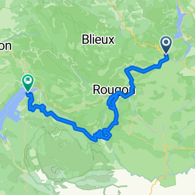
Route template
Castellane to Riez

- 4 h 52 min
- Duration
- 63.4 km
- Distance
- 2,287 m
- Ascent
- 2,604 m
- Descent
- 13 km/h
- Avg. speed
- 1,241 m
- Max. altitude
This ride takes you from the charming town of Castellane, nestled on the edge of the Verdon Gorge, to the historic market town of Riez. You’ll cover about 63 kilometers, rolling through a mix of paved and gravel roads—so be ready for a bit of adventure (and maybe some dust). Expect plenty of ups and downs; you’ll climb over 2,200 meters, with stunning views from elevations above 1,200 meters. This area is classic Provence: think limestone cliffs, lavender fields (if you’re lucky with timing), and hidden hamlets along quiet and occasionally bumpy tracks.
Castellane itself is famous for its dramatic rock outcrop and as a gateway to the spectacular Gorges du Verdon. Riez at the finish is one of Provence’s oldest towns, with Roman ruins and a lovely café-lined square—perfect for a coffee or ice cream after the ride. With mostly quiet roads and tracks, plus some stretches of gravel and unpaved surfaces, this route promises both challenge and beauty. Don’t forget your camera!
Community
Top users in this region


From our community
The best bike routes from Castellane to Riez

Objezd kan.Verdon ze SEVERU_4.den
Cycling route in Castellane, Provence-Alpes-Côte d'Azur Region, France
- 41.8 km
- Distance
- 1,011 m
- Ascent
- 1,277 m
- Descent

4. Trigance - Moustier-Sainte - Marie
Cycling route in Castellane, Provence-Alpes-Côte d'Azur Region, France
- 46.3 km
- Distance
- 1,031 m
- Ascent
- 1,332 m
- Descent

La Palud-sur-Verdon - Les Salles-sur-Verdon
Cycling route in Castellane, Provence-Alpes-Côte d'Azur Region, France
- 19.7 km
- Distance
- 354 m
- Ascent
- 797 m
- Descent

2011.09.27 Francia 4 Verdonsky kaňon
Cycling route in Castellane, Provence-Alpes-Côte d'Azur Region, France
- 44.9 km
- Distance
- 1,280 m
- Ascent
- 1,718 m
- Descent

Rougon_Les Salles-sur-Verdon
Cycling route in Castellane, Provence-Alpes-Côte d'Azur Region, France
- 54 km
- Distance
- 1,055 m
- Ascent
- 1,220 m
- Descent

2_FR_Castellane-Grand Canyon
Cycling route in Castellane, Provence-Alpes-Côte d'Azur Region, France
- 66.8 km
- Distance
- 1,273 m
- Ascent
- 1,510 m
- Descent

Etape 14 St André les Alpes -> Aiguines
Cycling route in Castellane, Provence-Alpes-Côte d'Azur Region, France
- 65.2 km
- Distance
- 649 m
- Ascent
- 1,048 m
- Descent

Castellane - Moustier-Sainte-Marie
Cycling route in Castellane, Provence-Alpes-Côte d'Azur Region, France
- 69.2 km
- Distance
- 1,344 m
- Ascent
- 1,481 m
- Descent

Castellane - Moustiers Sainte Marie
Cycling route in Castellane, Provence-Alpes-Côte d'Azur Region, France
- 44.8 km
- Distance
- 661 m
- Ascent
- 810 m
- Descent

Průjezd kan. Verdon z JIHU_6.den
Cycling route in Castellane, Provence-Alpes-Côte d'Azur Region, France
- 63.6 km
- Distance
- 1,306 m
- Ascent
- 1,572 m
- Descent

baremme riez
Cycling route in Castellane, Provence-Alpes-Côte d'Azur Region, France
- 128.2 km
- Distance
- 1,489 m
- Ascent
- 1,638 m
- Descent

Trigance-Moustiers Saint Marie
Cycling route in Castellane, Provence-Alpes-Côte d'Azur Region, France
- 42.3 km
- Distance
- 1,199 m
- Ascent
- 1,317 m
- Descent
Discover more routes
 Rougon_Les Salles-sur-Verdon
- Distance
- 54 km
- Ascent
- 1,055 m
- Descent
- 1,220 m
- Location
- Castellane, Provence-Alpes-Côte d'Azur Region, France
 2_FR_Castellane-Grand Canyon
- Distance
- 66.8 km
- Ascent
- 1,273 m
- Descent
- 1,510 m
- Location
- Castellane, Provence-Alpes-Côte d'Azur Region, France
 Etape 14 St André les Alpes -> Aiguines
- Distance
- 65.2 km
- Ascent
- 649 m
- Descent
- 1,048 m
- Location
- Castellane, Provence-Alpes-Côte d'Azur Region, France
 Castellane - Moustier-Sainte-Marie
- Distance
- 69.2 km
- Ascent
- 1,344 m
- Descent
- 1,481 m
- Location
- Castellane, Provence-Alpes-Côte d'Azur Region, France
 Castellane - Moustiers Sainte Marie
- Distance
- 44.8 km
- Ascent
- 661 m
- Descent
- 810 m
- Location
- Castellane, Provence-Alpes-Côte d'Azur Region, France
 Průjezd kan. Verdon z JIHU_6.den
- Distance
- 63.6 km
- Ascent
- 1,306 m
- Descent
- 1,572 m
- Location
- Castellane, Provence-Alpes-Côte d'Azur Region, France
 baremme riez
- Distance
- 128.2 km
- Ascent
- 1,489 m
- Descent
- 1,638 m
- Location
- Castellane, Provence-Alpes-Côte d'Azur Region, France
 Trigance-Moustiers Saint Marie
- Distance
- 42.3 km
- Ascent
- 1,199 m
- Descent
- 1,317 m
- Location
- Castellane, Provence-Alpes-Côte d'Azur Region, France