
By bicycle from Briançon to Le Monêtier-les-Bains
Customize your own route based on our template or discover how our community prefers to cycle from Briançon to Le Monêtier-les-Bains.
Route template
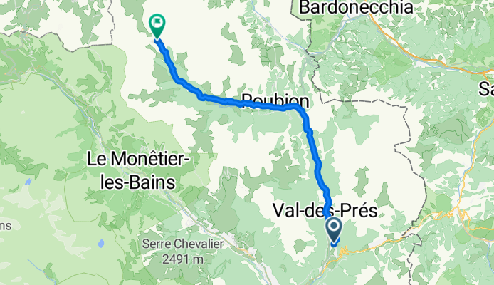
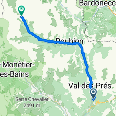
Briançon to Le Monêtier-les-Bains

- 1 h 15 min
- Duration
- 17.5 km
- Distance
- 432 m
- Ascent
- 257 m
- Descent
- 14 km/h
- Avg. speed
- 1,477 m
- Max. altitude
This scenic cycling route kicks off in Briançon, Europe’s highest city, known for its dramatic Vauban fortifications and panoramic mountain views. From here, you’ll head northwest towards the charming spa village of Le Monêtier-les-Bains, tucked away at nearly 1,500 meters in the Serre Chevalier valley.
The ride is about 17.5 km, tracing mostly quiet roads, with a solid mix of paved and gravel sections—perfect for those who enjoy a bit of adventure and don’t mind a little gravel dust. You’ll climb around 430 meters before gliding back down almost 260, so expect some gentle workout for your legs, but you'll be rewarded with gorgeous alpine scenery along the way.
Le Monêtier-les-Bains is famous for its natural hot springs, making it perfect for a post-ride soak. All in all, this route blends mountain history, epic views, and a relaxing finish—just don’t forget your camera and maybe a swimsuit for that spa at the end!
Community
Top users in this region


From our community
The best bike routes from Briançon to Le Monêtier-les-Bains

De Briançon au pré de Madame Carle
Cycling route in Briançon, Provence-Alpes-Côte d'Azur Region, France
- 39.8 km
- Distance
- 1,187 m
- Ascent
- 518 m
- Descent

Briancon-Col du Lautaret
Cycling route in Briançon, Provence-Alpes-Côte d'Azur Region, France
- 30.1 km
- Distance
- 865 m
- Ascent
- 113 m
- Descent

Briancon bis col du Lautaret
Cycling route in Briançon, Provence-Alpes-Côte d'Azur Region, France
- 28.1 km
- Distance
- 826 m
- Ascent
- 54 m
- Descent

Du Suite Home au refuge de Laval par la vallée de la Clarée
Cycling route in Briançon, Provence-Alpes-Côte d'Azur Region, France
- 31.4 km
- Distance
- 769 m
- Ascent
- 4 m
- Descent

Nevache CLONED FROM ROUTE 969165
Cycling route in Briançon, Provence-Alpes-Côte d'Azur Region, France
- 21.5 km
- Distance
- 507 m
- Ascent
- 95 m
- Descent
01_Val des Prés - Refuge de Laval 25/700
Cycling route in Briançon, Provence-Alpes-Côte d'Azur Region, France
- 24.4 km
- Distance
- 688 m
- Ascent
- 30 m
- Descent

Galiber
Cycling route in Briançon, Provence-Alpes-Côte d'Azur Region, France
- 28.8 km
- Distance
- 877 m
- Ascent
- 21 m
- Descent

Briancon-Ailefroide/Barre des Ecrins, Tag 6
Cycling route in Briançon, Provence-Alpes-Côte d'Azur Region, France
- 28.3 km
- Distance
- 577 m
- Ascent
- 300 m
- Descent

GraphHopper Track
Cycling route in Briançon, Provence-Alpes-Côte d'Azur Region, France
- 30.1 km
- Distance
- 866 m
- Ascent
- 114 m
- Descent
01_Val-des-Prés bis Névache 30/900
Cycling route in Briançon, Provence-Alpes-Côte d'Azur Region, France
- 28 km
- Distance
- 889 m
- Ascent
- 141 m
- Descent

Co du Lauterat
Cycling route in Briançon, Provence-Alpes-Côte d'Azur Region, France
- 26.6 km
- Distance
- 825 m
- Ascent
- 19 m
- Descent

Col du Lautaret
Cycling route in Briançon, Provence-Alpes-Côte d'Azur Region, France
- 28.3 km
- Distance
- 801 m
- Ascent
- 42 m
- Descent
Discover more routes
 Nevache CLONED FROM ROUTE 969165
- Distance
- 21.5 km
- Ascent
- 507 m
- Descent
- 95 m
- Location
- Briançon, Provence-Alpes-Côte d'Azur Region, France
 01_Val des Prés - Refuge de Laval 25/700
- Distance
- 24.4 km
- Ascent
- 688 m
- Descent
- 30 m
- Location
- Briançon, Provence-Alpes-Côte d'Azur Region, France
 Galiber
- Distance
- 28.8 km
- Ascent
- 877 m
- Descent
- 21 m
- Location
- Briançon, Provence-Alpes-Côte d'Azur Region, France
 Briancon-Ailefroide/Barre des Ecrins, Tag 6
- Distance
- 28.3 km
- Ascent
- 577 m
- Descent
- 300 m
- Location
- Briançon, Provence-Alpes-Côte d'Azur Region, France
 GraphHopper Track
- Distance
- 30.1 km
- Ascent
- 866 m
- Descent
- 114 m
- Location
- Briançon, Provence-Alpes-Côte d'Azur Region, France
 01_Val-des-Prés bis Névache 30/900
- Distance
- 28 km
- Ascent
- 889 m
- Descent
- 141 m
- Location
- Briançon, Provence-Alpes-Côte d'Azur Region, France
 Co du Lauterat
- Distance
- 26.6 km
- Ascent
- 825 m
- Descent
- 19 m
- Location
- Briançon, Provence-Alpes-Côte d'Azur Region, France
 Col du Lautaret
- Distance
- 28.3 km
- Ascent
- 801 m
- Descent
- 42 m
- Location
- Briançon, Provence-Alpes-Côte d'Azur Region, France
Routes from Briançon
Cycling day trip from
Briançon to Jausiers
Cycling day trip from
Briançon to Huez
By bicycle from
Briançon to Villar-Saint-Pancrace
By bicycle from
Briançon to Villeneuve