
Cycling day trip from Bourg-Saint-Maurice to Modane
Customize your own route based on our template or discover how our community prefers to cycle from Bourg-Saint-Maurice to Modane.
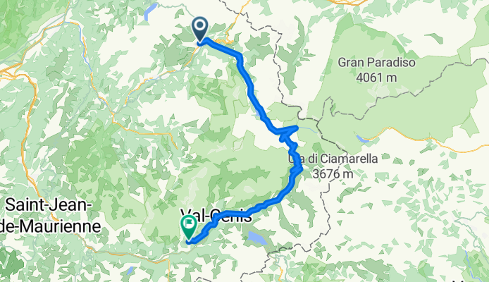
Route template
Bourg-Saint-Maurice to Modane

- 12 h 28 min
- Duration
- 123 km
- Distance
- 6,494 m
- Ascent
- 6,264 m
- Descent
- 9.9 km/h
- Avg. speed
- 2,991 m
- Max. altitude
Ready for an epic cycling adventure through the French Alps? Kick-off from Bourg-Saint-Maurice, a charming town known as a gateway to the paradisal Tarentaise Valley. It's a lively hub for outdoor enthusiasts, with its picturesque views and vibrant local vibe.
Your journey will roll on to Modane, a picturesque Alpine town nestled in the Maurienne Valley. Along the way, you'll ride through some jaw-dropping landscapes with diverse terrains making it both challenging and exhilarating. This route takes you to astounding heights with a maximum elevation of nearly 2990 meters—talk about cycling on top of the world!
Be prepared for a variety of surfaces. About 37% is on smooth asphalt, but expect some adventure with gravel and ground tracks. The route mostly ambles through serene tracks and quiet roads, perfect for those who prefer the road less traveled. With that mix, every pedal stroke promises a unique experience.
Modane will greet you with its quaint alpine charm. It's the perfect spot to decompress, surrounded by panoramic mountain views and welcoming local taverns. So, gear up for this amazing ride and remember to savor every twist and turn!
Community
Top users in this region


From our community
The best bike routes from Bourg-Saint-Maurice to Modane

RGA Tag 3
Cycling route in Bourg-Saint-Maurice, Auvergne-Rhône-Alpes, France
- 104.8 km
- Distance
- 2,100 m
- Ascent
- 1,884 m
- Descent

Francia Alpok 03 vándor
Cycling route in Bourg-Saint-Maurice, Auvergne-Rhône-Alpes, France
- 97.4 km
- Distance
- 2,310 m
- Ascent
- 1,645 m
- Descent

RDGA-03 - Bourg-Saint-Maurice - Modane
Cycling route in Bourg-Saint-Maurice, Auvergne-Rhône-Alpes, France
- 158.6 km
- Distance
- 4,084 m
- Ascent
- 3,867 m
- Descent

RdGA - Stage 3 (Var. Mont Cenis)
Cycling route in Bourg-Saint-Maurice, Auvergne-Rhône-Alpes, France
- 120.1 km
- Distance
- 2,820 m
- Ascent
- 2,242 m
- Descent

RdGA - Stage 3
Cycling route in Bourg-Saint-Maurice, Auvergne-Rhône-Alpes, France
- 79.8 km
- Distance
- 2,056 m
- Ascent
- 1,475 m
- Descent
CLemay-Alpes-Jour7-BourStMaurice-Aussois
Cycling route in Bourg-Saint-Maurice, Auvergne-Rhône-Alpes, France
- 98 km
- Distance
- 2,366 m
- Ascent
- 1,682 m
- Descent

Route des Grandes Alpes Stage 3
Cycling route in Bourg-Saint-Maurice, Auvergne-Rhône-Alpes, France
- 79.8 km
- Distance
- 2,057 m
- Ascent
- 1,472 m
- Descent

RDGA - Etape 2
Cycling route in Bourg-Saint-Maurice, Auvergne-Rhône-Alpes, France
- 103 km
- Distance
- 2,079 m
- Ascent
- 1,826 m
- Descent

Bourg-Saint-Maurice naar Lanslebourg (80km)
Cycling route in Bourg-Saint-Maurice, Auvergne-Rhône-Alpes, France
- 80.4 km
- Distance
- 2,050 m
- Ascent
- 1,465 m
- Descent

4. Bourg-St. Maurice - Val d´Isere - Col d´Iseran - Modane - Aussois (100km, 2600hm)
Cycling route in Bourg-Saint-Maurice, Auvergne-Rhône-Alpes, France
- 97.9 km
- Distance
- 2,295 m
- Ascent
- 1,647 m
- Descent

1. Etappe Route des Grand Alpes Bourg-Saint-Maurice - Lanslebourg Mont- Cenis
Cycling route in Bourg-Saint-Maurice, Auvergne-Rhône-Alpes, France
- 81.7 km
- Distance
- 2,012 m
- Ascent
- 1,432 m
- Descent

BstM-Aussois
Cycling route in Bourg-Saint-Maurice, Auvergne-Rhône-Alpes, France
- 96.6 km
- Distance
- 2,383 m
- Ascent
- 1,713 m
- Descent
Discover more routes
 RdGA - Stage 3
- Distance
- 79.8 km
- Ascent
- 2,056 m
- Descent
- 1,475 m
- Location
- Bourg-Saint-Maurice, Auvergne-Rhône-Alpes, France
 CLemay-Alpes-Jour7-BourStMaurice-Aussois
- Distance
- 98 km
- Ascent
- 2,366 m
- Descent
- 1,682 m
- Location
- Bourg-Saint-Maurice, Auvergne-Rhône-Alpes, France
 Route des Grandes Alpes Stage 3
- Distance
- 79.8 km
- Ascent
- 2,057 m
- Descent
- 1,472 m
- Location
- Bourg-Saint-Maurice, Auvergne-Rhône-Alpes, France
 RDGA - Etape 2
- Distance
- 103 km
- Ascent
- 2,079 m
- Descent
- 1,826 m
- Location
- Bourg-Saint-Maurice, Auvergne-Rhône-Alpes, France
 Bourg-Saint-Maurice naar Lanslebourg (80km)
- Distance
- 80.4 km
- Ascent
- 2,050 m
- Descent
- 1,465 m
- Location
- Bourg-Saint-Maurice, Auvergne-Rhône-Alpes, France
 4. Bourg-St. Maurice - Val d´Isere - Col d´Iseran - Modane - Aussois (100km, 2600hm)
- Distance
- 97.9 km
- Ascent
- 2,295 m
- Descent
- 1,647 m
- Location
- Bourg-Saint-Maurice, Auvergne-Rhône-Alpes, France
 1. Etappe Route des Grand Alpes Bourg-Saint-Maurice - Lanslebourg Mont- Cenis
- Distance
- 81.7 km
- Ascent
- 2,012 m
- Descent
- 1,432 m
- Location
- Bourg-Saint-Maurice, Auvergne-Rhône-Alpes, France
 BstM-Aussois
- Distance
- 96.6 km
- Ascent
- 2,383 m
- Descent
- 1,713 m
- Location
- Bourg-Saint-Maurice, Auvergne-Rhône-Alpes, France
Routes from Bourg-Saint-Maurice
Cycling day trip from
Bourg-Saint-Maurice to Val d'Isère
Cycling day trip from
Bourg-Saint-Maurice to Saint-Michel-de-Maurienne
Quick ride by bicycle from
Bourg-Saint-Maurice to Séez
Routes to Modane
Cycling day trip from
Séez to Modane