
By bicycle from Blagnac to Plaisance-du-Touch
Customize your own route based on our template or discover how our community prefers to cycle from Blagnac to Plaisance-du-Touch.
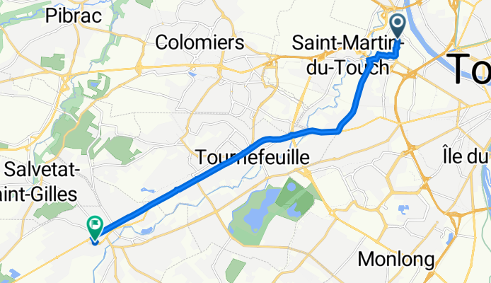
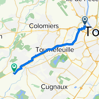
Route template
Blagnac to Plaisance-du-Touch

- 57 min
- Duration
- 16.6 km
- Distance
- 58 m
- Ascent
- 33 m
- Descent
- 17.5 km/h
- Avg. speed
- 168 m
- Max. altitude
This ride takes you from Blagnac, a vibrant suburb northwest of Toulouse known for its close connection to the city’s aviation industry (hello, Airbus headquarters!), down to the charming town of Plaisance-du-Touch. Covering just over 16.5 km, the route is mostly paved and pretty flat, with only about 58 meters of gentle ascent, making it an easy spin suitable for most riders.
The route mainly follows designated cycleways (over 80%), so you’ll get to enjoy a relaxed pedal without much traffic. As you leave Blagnac and its riverside parks, you’ll pass through some quieter suburban neighborhoods and a sprinkle of green spaces. The ride winds up in Plaisance-du-Touch, a friendly community with a scenic lake and lovely local bakeries—perfect for a post-ride treat.
This is a great route if you want a safe, mostly car-free cruise with a mix of urban and semi-rural vibes. Just make sure you’re ready for a short stretch on gravel, but otherwise, it’s smooth sailing!
Community
Top users in this region


From our community
The best bike routes from Blagnac to Plaisance-du-Touch

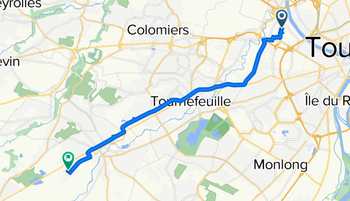
Avenue des Arènes Romaines, Toulouse à 2 bis Rue de Fronton, Plaisance-du-Touch
Cycling route in Blagnac, Occitanie, France
- 16.3 km
- Distance
- 80 m
- Ascent
- 62 m
- Descent

Avenue des Arènes Romaines, Toulouse à 2 bis Rue de Fronton, Plaisance-du-Touch
Cycling route in Blagnac, Occitanie, France
- 13.3 km
- Distance
- 40 m
- Ascent
- 23 m
- Descent

Avenue des Arènes Romaines, Toulouse à 2 bis Rue de Fronton, Plaisance-du-Touch
Cycling route in Blagnac, Occitanie, France
- 13.1 km
- Distance
- 37 m
- Ascent
- 20 m
- Descent

Avenue des Arènes Romaines, Toulouse à 2 bis Rue de Fronton, Plaisance-du-Touch
Cycling route in Blagnac, Occitanie, France
- 13.6 km
- Distance
- 38 m
- Ascent
- 23 m
- Descent

Avenue des Arènes Romaines, Toulouse à 4 Rue de Fronton, Plaisance-du-Touch
Cycling route in Blagnac, Occitanie, France
- 13.1 km
- Distance
- 37 m
- Ascent
- 20 m
- Descent

Avenue des Arènes Romaines, Toulouse à 2 bis Rue de Fronton, Plaisance-du-Touch
Cycling route in Blagnac, Occitanie, France
- 13.2 km
- Distance
- 36 m
- Ascent
- 19 m
- Descent

Avenue des Arènes Romaines, Toulouse à 2 bis Rue de Fronton, Plaisance-du-Touch
Cycling route in Blagnac, Occitanie, France
- 13.3 km
- Distance
- 29 m
- Ascent
- 12 m
- Descent

Avenue des Arènes Romaines, Toulouse à 2 bis Rue de Fronton, Plaisance-du-Touch
Cycling route in Blagnac, Occitanie, France
- 13.3 km
- Distance
- 33 m
- Ascent
- 17 m
- Descent

Avenue des Arènes Romaines, Toulouse à 46 Avenue de la Casse, Plaisance-du-Touch
Cycling route in Blagnac, Occitanie, France
- 12.8 km
- Distance
- 26 m
- Ascent
- 10 m
- Descent

Avenue des Arènes Romaines, Toulouse à 9 Rue de Beoulaygue, Plaisance-du-Touch
Cycling route in Blagnac, Occitanie, France
- 11.3 km
- Distance
- 23 m
- Ascent
- 7 m
- Descent
Itinéraire à partir de Avenue des Arènes Romaines, Toulouse
Cycling route in Blagnac, Occitanie, France
- 11.6 km
- Distance
- 27 m
- Ascent
- 14 m
- Descent
Avenue des Arènes Romaines, Toulouse à 2 bis Rue de Fronton, Plaisance-du-Touch
Cycling route in Blagnac, Occitanie, France
- 13.5 km
- Distance
- 36 m
- Ascent
- 20 m
- Descent
Discover more routes
 Avenue des Arènes Romaines, Toulouse à 4 Rue de Fronton, Plaisance-du-Touch
- Distance
- 13.1 km
- Ascent
- 37 m
- Descent
- 20 m
- Location
- Blagnac, Occitanie, France
 Avenue des Arènes Romaines, Toulouse à 2 bis Rue de Fronton, Plaisance-du-Touch
- Distance
- 13.2 km
- Ascent
- 36 m
- Descent
- 19 m
- Location
- Blagnac, Occitanie, France
 Avenue des Arènes Romaines, Toulouse à 2 bis Rue de Fronton, Plaisance-du-Touch
- Distance
- 13.3 km
- Ascent
- 29 m
- Descent
- 12 m
- Location
- Blagnac, Occitanie, France
 Avenue des Arènes Romaines, Toulouse à 2 bis Rue de Fronton, Plaisance-du-Touch
- Distance
- 13.3 km
- Ascent
- 33 m
- Descent
- 17 m
- Location
- Blagnac, Occitanie, France
 Avenue des Arènes Romaines, Toulouse à 46 Avenue de la Casse, Plaisance-du-Touch
- Distance
- 12.8 km
- Ascent
- 26 m
- Descent
- 10 m
- Location
- Blagnac, Occitanie, France
 Avenue des Arènes Romaines, Toulouse à 9 Rue de Beoulaygue, Plaisance-du-Touch
- Distance
- 11.3 km
- Ascent
- 23 m
- Descent
- 7 m
- Location
- Blagnac, Occitanie, France
 Itinéraire à partir de Avenue des Arènes Romaines, Toulouse
- Distance
- 11.6 km
- Ascent
- 27 m
- Descent
- 14 m
- Location
- Blagnac, Occitanie, France
 Avenue des Arènes Romaines, Toulouse à 2 bis Rue de Fronton, Plaisance-du-Touch
- Distance
- 13.5 km
- Ascent
- 36 m
- Descent
- 20 m
- Location
- Blagnac, Occitanie, France
Routes from Blagnac
By bicycle from
Blagnac to Toulouse
Routes to Plaisance-du-Touch
By bicycle from
Portet-sur-Garonne to Plaisance-du-Touch