
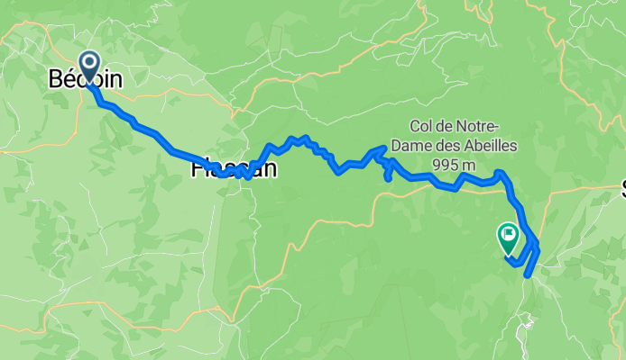
Route template
Bédoin to Sault

- 2 h 24 min
- Duration
- 31.4 km
- Distance
- 1,058 m
- Ascent
- 663 m
- Descent
- 13.1 km/h
- Avg. speed
- 1,019 m
- Max. altitude
Looking for a classic Provencal cycling adventure? This route takes you from the charming village of Bédoin, famous as a jump-off point for climbing Mont Ventoux, all the way to Sault—another picturesque Provençal gem surrounded by lavender fields. The ride is just over 31 km, with a hearty ascent of around 1,058 meters, so be ready to test your legs on some serious climbs!
You’ll pedal mostly on tracks and quiet roads, soaking up gorgeous views of rolling hills, scattered vineyards, and those iconic stone farmhouses. The route is about three-quarters missing from detailed surface reports, but expect a mix of paved, gravel, and even some unpaved stretches—so a gravel or sturdy road bike is best.
Bédoin is known for its lively markets and cycling culture, while Sault is your gateway to endless lavender in summer. Perfect for a scenic, challenging ride with a laid-back Provençal vibe. Don’t forget to reward yourself with a coffee and pastry in Sault’s village square at the finish!
Community
Top users in this region


From our community
The best bike routes from Bédoin to Sault

Col des Tempétes (Mt. Ventoux)
Cycling route in Bédoin, Provence-Alpes-Côte d'Azur Region, France
- 60.7 km
- Distance
- 2,206 m
- Ascent
- 1,763 m
- Descent

2-Ventoux-hotel
Cycling route in Bédoin, Provence-Alpes-Côte d'Azur Region, France
- 67.8 km
- Distance
- 1,201 m
- Ascent
- 2,133 m
- Descent

Bedoin Sault
Cycling route in Bédoin, Provence-Alpes-Côte d'Azur Region, France
- 43.7 km
- Distance
- 987 m
- Ascent
- 555 m
- Descent

Bedoin - Sault
Cycling route in Bédoin, Provence-Alpes-Côte d'Azur Region, France
- 43.8 km
- Distance
- 1,749 m
- Ascent
- 1,282 m
- Descent

Tour des Irons 3b: Mont Ventoux
Cycling route in Bédoin, Provence-Alpes-Côte d'Azur Region, France
- 75.6 km
- Distance
- 1,908 m
- Ascent
- 1,357 m
- Descent

de Mont Ventoux 2
Cycling route in Bédoin, Provence-Alpes-Côte d'Azur Region, France
- 11.9 km
- Distance
- 960 m
- Ascent
- 0 m
- Descent

Bedoin - Mont Ventoux - Sault
Cycling route in Bédoin, Provence-Alpes-Côte d'Azur Region, France
- 47.7 km
- Distance
- 2,000 m
- Ascent
- 1,453 m
- Descent

ventoux
Cycling route in Bédoin, Provence-Alpes-Côte d'Azur Region, France
- 38.3 km
- Distance
- 1,177 m
- Ascent
- 1,198 m
- Descent
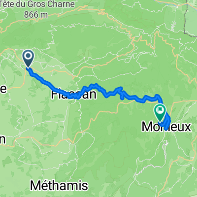
From Bédoin to Monieux
Cycling route in Bédoin, Provence-Alpes-Côte d'Azur Region, France
- 27.5 km
- Distance
- 1,106 m
- Ascent
- 514 m
- Descent

Tour des Irons 3: Mont Ventoux
Cycling route in Bédoin, Provence-Alpes-Côte d'Azur Region, France
- 75.1 km
- Distance
- 1,889 m
- Ascent
- 1,326 m
- Descent

Recovery ride from Bedoin ( 4 )
Cycling route in Bédoin, Provence-Alpes-Côte d'Azur Region, France
- 53.3 km
- Distance
- 1,151 m
- Ascent
- 478 m
- Descent

DAY 7 - Bedoin to Mt Ventoux and Mas de Reilhanette (Long opition option from Bedoin)
Cycling route in Bédoin, Provence-Alpes-Côte d'Azur Region, France
- 57.4 km
- Distance
- 1,757 m
- Ascent
- 1,490 m
- Descent
Discover more routes
 Tour des Irons 3b: Mont Ventoux
- Distance
- 75.6 km
- Ascent
- 1,908 m
- Descent
- 1,357 m
- Location
- Bédoin, Provence-Alpes-Côte d'Azur Region, France
 de Mont Ventoux 2
- Distance
- 11.9 km
- Ascent
- 960 m
- Descent
- 0 m
- Location
- Bédoin, Provence-Alpes-Côte d'Azur Region, France
 Bedoin - Mont Ventoux - Sault
- Distance
- 47.7 km
- Ascent
- 2,000 m
- Descent
- 1,453 m
- Location
- Bédoin, Provence-Alpes-Côte d'Azur Region, France
 ventoux
- Distance
- 38.3 km
- Ascent
- 1,177 m
- Descent
- 1,198 m
- Location
- Bédoin, Provence-Alpes-Côte d'Azur Region, France
 From Bédoin to Monieux
- Distance
- 27.5 km
- Ascent
- 1,106 m
- Descent
- 514 m
- Location
- Bédoin, Provence-Alpes-Côte d'Azur Region, France
 Tour des Irons 3: Mont Ventoux
- Distance
- 75.1 km
- Ascent
- 1,889 m
- Descent
- 1,326 m
- Location
- Bédoin, Provence-Alpes-Côte d'Azur Region, France
 Recovery ride from Bedoin ( 4 )
- Distance
- 53.3 km
- Ascent
- 1,151 m
- Descent
- 478 m
- Location
- Bédoin, Provence-Alpes-Côte d'Azur Region, France
 DAY 7 - Bedoin to Mt Ventoux and Mas de Reilhanette (Long opition option from Bedoin)
- Distance
- 57.4 km
- Ascent
- 1,757 m
- Descent
- 1,490 m
- Location
- Bédoin, Provence-Alpes-Côte d'Azur Region, France
Routes from Bédoin
Quick ride by bicycle from
Bédoin to Malaucène