
Cycling day trip from Bagnères-de-Luchon to Saint-Lary-Soulan
Customize your own route based on our template or discover how our community prefers to cycle from Bagnères-de-Luchon to Saint-Lary-Soulan.
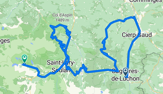
Route template
Bagnères-de-Luchon to Saint-Lary-Soulan

- 4 h 38 min
- Duration
- 45.3 km
- Distance
- 2,557 m
- Ascent
- 2,367 m
- Descent
- 9.8 km/h
- Avg. speed
- 1,975 m
- Max. altitude
Ready for a legendary Pyrenean ride? Set out from the spa town of Bagnères-de-Luchon, known for its Belle Époque charm and iconic “Vélo d’Or” cycling heritage. The route to Saint-Lary-Soulan covers about 45 km, but with over 2500 meters of climbing, it’s a true mountain adventure!
You’ll wind your way up high mountain roads and tracks, with nearly half the ride on smooth asphalt, but you’ll also tackle some gravel and ground—so be ready for mixed surfaces. The ascent is huge, but every pedal stroke brings stunning views: think sweeping valleys, waterfalls, and maybe a glimpse of wild marmots. Top out just under 2000 meters, then enjoy a thrilling descent towards Saint-Lary-Soulan, a lively mountain village famed for its ski slopes and thermal baths (perfect for a post-ride soak!).
This ride blends classic Tour de France energy with tranquil mountain vibes—ideal for riders who like a challenge and plenty of scenery. Don’t forget layers and snacks—the Pyrenees weather can keep you guessing!
Community
Top users in this region


From our community
The best bike routes from Bagnères-de-Luchon to Saint-Lary-Soulan

stage 1 B (long option) Luchon -St lary
Cycling route in Bagnères-de-Luchon, Occitanie, France
- 101.7 km
- Distance
- 2,509 m
- Ascent
- 2,306 m
- Descent

Tourreko etapa
Cycling route in Bagnères-de-Luchon, Occitanie, France
- 62.5 km
- Distance
- 2,656 m
- Ascent
- 1,480 m
- Descent

Jezero
Cycling route in Bagnères-de-Luchon, Occitanie, France
- 31.6 km
- Distance
- 1,613 m
- Ascent
- 658 m
- Descent

Kolem jezera
Cycling route in Bagnères-de-Luchon, Occitanie, France
- 32.7 km
- Distance
- 1,570 m
- Ascent
- 705 m
- Descent

Le Tour De France: Stage 18
Cycling route in Bagnères-de-Luchon, Occitanie, France
- 148 km
- Distance
- 3,963 m
- Ascent
- 2,394 m
- Descent

Stage 17 Tour de France 2012 from Bagnères-de-Luchon to Peyragudes
Cycling route in Bagnères-de-Luchon, Occitanie, France
- 148.1 km
- Distance
- 3,244 m
- Ascent
- 2,278 m
- Descent

Bagnères-de-Luchon - Val-Louron
Cycling route in Bagnères-de-Luchon, Occitanie, France
- 31.1 km
- Distance
- 1,458 m
- Ascent
- 644 m
- Descent
Etape 19 : Bagnères de Luchon-lac d'Oredon
Cycling route in Bagnères-de-Luchon, Occitanie, France
- 179.2 km
- Distance
- 4,714 m
- Ascent
- 3,482 m
- Descent

ETAPA TOUR
Cycling route in Bagnères-de-Luchon, Occitanie, France
- 15 km
- Distance
- 1,086 m
- Ascent
- 434 m
- Descent
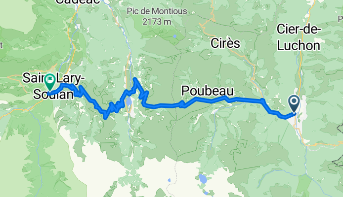
Stage 1 A (short option) Luchon - St Lary
Cycling route in Bagnères-de-Luchon, Occitanie, France
- 43.4 km
- Distance
- 1,583 m
- Ascent
- 1,377 m
- Descent

1 - Luchon-Aragnouet
Cycling route in Bagnères-de-Luchon, Occitanie, France
- 93.3 km
- Distance
- 2,719 m
- Ascent
- 2,172 m
- Descent

PEYRAGUDES, por Bagnères de Luchon
Cycling route in Bagnères-de-Luchon, Occitanie, France
- 16.7 km
- Distance
- 1,286 m
- Ascent
- 304 m
- Descent
Discover more routes
 Le Tour De France: Stage 18
- Distance
- 148 km
- Ascent
- 3,963 m
- Descent
- 2,394 m
- Location
- Bagnères-de-Luchon, Occitanie, France
 Stage 17 Tour de France 2012 from Bagnères-de-Luchon to Peyragudes
- Distance
- 148.1 km
- Ascent
- 3,244 m
- Descent
- 2,278 m
- Location
- Bagnères-de-Luchon, Occitanie, France
 Bagnères-de-Luchon - Val-Louron
- Distance
- 31.1 km
- Ascent
- 1,458 m
- Descent
- 644 m
- Location
- Bagnères-de-Luchon, Occitanie, France
 Etape 19 : Bagnères de Luchon-lac d'Oredon
- Distance
- 179.2 km
- Ascent
- 4,714 m
- Descent
- 3,482 m
- Location
- Bagnères-de-Luchon, Occitanie, France
 ETAPA TOUR
- Distance
- 15 km
- Ascent
- 1,086 m
- Descent
- 434 m
- Location
- Bagnères-de-Luchon, Occitanie, France
 Stage 1 A (short option) Luchon - St Lary
- Distance
- 43.4 km
- Ascent
- 1,583 m
- Descent
- 1,377 m
- Location
- Bagnères-de-Luchon, Occitanie, France
 1 - Luchon-Aragnouet
- Distance
- 93.3 km
- Ascent
- 2,719 m
- Descent
- 2,172 m
- Location
- Bagnères-de-Luchon, Occitanie, France
 PEYRAGUDES, por Bagnères de Luchon
- Distance
- 16.7 km
- Ascent
- 1,286 m
- Descent
- 304 m
- Location
- Bagnères-de-Luchon, Occitanie, France
Routes from Bagnères-de-Luchon
Bikepacking from
Bagnères-de-Luchon to Bayonne
Cycling day trip from
Bagnères-de-Luchon to Luz-Saint-Sauveur
Cycling day trip from
Bagnères-de-Luchon to Saint-Girons
Routes to Saint-Lary-Soulan
Cycling day trip from
Luz-Saint-Sauveur to Saint-Lary-Soulan
Cycling day trip from
Campan to Saint-Lary-Soulan