
Cycling day trip from Argelès-Gazost to Campan
Customize your own route based on our template or discover how our community prefers to cycle from Argelès-Gazost to Campan.
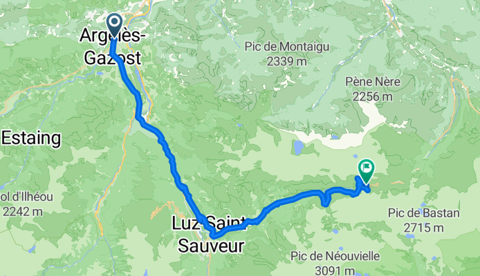
Route template
Argelès-Gazost to Campan

- 3 h 23 min
- Duration
- 50.1 km
- Distance
- 1,046 m
- Ascent
- 923 m
- Descent
- 14.8 km/h
- Avg. speed
- 666 m
- Max. altitude
Kick off your ride in the charming town of Argelès-Gazost, nestled at the crossroads of several classic Pyrenean passes. This area is known for its thermal baths and as a popular base for cyclists exploring the region. From here, you’ll head east toward Campan, traversing around 50 km with more than 1000 meters of climbing—expect a rewarding workout with plenty of stunning views!
The route mostly rolls along quiet roads, dipping occasionally onto cycleways and some paths. About half of the surface is paved, but be ready for some mixed terrain, including a bit of gravel and unpaved stretches—nothing too wild, just enough to spice things up. You’ll cross lush valleys, pass picturesque villages, and enjoy the peaceful scenery of the Pyrenean foothills.
Your destination, Campan, is famous for its traditional “mounaques”—life-sized dolls perched on balconies and benches around town, especially during summer. It's a perfect spot to relax, savor local cheeses, or just soak in the mountain vibes after a satisfying ride.
Community
Top users in this region


From our community
The best bike routes from Argelès-Gazost to Campan

COL DE TOURMALET (por Angeles-Gazost)
Cycling route in Argelès-Gazost, Occitanie, France
- 37.8 km
- Distance
- 1,989 m
- Ascent
- 335 m
- Descent
Argelès Tourmalet via Chèzes
Cycling route in Argelès-Gazost, Occitanie, France
- 39.1 km
- Distance
- 1,919 m
- Ascent
- 229 m
- Descent

Argelès-Gazost to Sainte-Marie de Campan
Cycling route in Argelès-Gazost, Occitanie, France
- 54.3 km
- Distance
- 0 m
- Ascent
- 0 m
- Descent

Cottage to Tourmalet
Cycling route in Argelès-Gazost, Occitanie, France
- 39.1 km
- Distance
- 1,894 m
- Ascent
- 317 m
- Descent


solur aubisq tourmalet
Cycling route in Argelès-Gazost, Occitanie, France
- 104.8 km
- Distance
- 3,230 m
- Ascent
- 1,571 m
- Descent

DÍA 3: ARGELÈS-GAZOST - COL DU TOURMALET - CAMPAN
Cycling route in Argelès-Gazost, Occitanie, France
- 60.7 km
- Distance
- 1,912 m
- Ascent
- 1,703 m
- Descent

100 cols 19
Cycling route in Argelès-Gazost, Occitanie, France
- 51.9 km
- Distance
- 1,630 m
- Ascent
- 1,400 m
- Descent

Tourmalet 2
Cycling route in Argelès-Gazost, Occitanie, France
- 36.1 km
- Distance
- 1,869 m
- Ascent
- 239 m
- Descent

Ascension a Tourmalet
Cycling route in Argelès-Gazost, Occitanie, France
- 39.8 km
- Distance
- 1,699 m
- Ascent
- 16 m
- Descent

ガゾストからカンバン「ピレネー山脈を走る」
Cycling route in Argelès-Gazost, Occitanie, France
- 59.3 km
- Distance
- 1,701 m
- Ascent
- 1,521 m
- Descent
Discover more routes
 toumalet
- Distance
- 53 km
- Ascent
- 1,702 m
- Descent
- 1,318 m
- Location
- Argelès-Gazost, Occitanie, France
 tuormalet
- Distance
- 34.4 km
- Ascent
- 1,618 m
- Descent
- 127 m
- Location
- Argelès-Gazost, Occitanie, France
 solur aubisq tourmalet
- Distance
- 104.8 km
- Ascent
- 3,230 m
- Descent
- 1,571 m
- Location
- Argelès-Gazost, Occitanie, France
 DÍA 3: ARGELÈS-GAZOST - COL DU TOURMALET - CAMPAN
- Distance
- 60.7 km
- Ascent
- 1,912 m
- Descent
- 1,703 m
- Location
- Argelès-Gazost, Occitanie, France
 100 cols 19
- Distance
- 51.9 km
- Ascent
- 1,630 m
- Descent
- 1,400 m
- Location
- Argelès-Gazost, Occitanie, France
 Tourmalet 2
- Distance
- 36.1 km
- Ascent
- 1,869 m
- Descent
- 239 m
- Location
- Argelès-Gazost, Occitanie, France
 Ascension a Tourmalet
- Distance
- 39.8 km
- Ascent
- 1,699 m
- Descent
- 16 m
- Location
- Argelès-Gazost, Occitanie, France
 ガゾストからカンバン「ピレネー山脈を走る」
- Distance
- 59.3 km
- Ascent
- 1,701 m
- Descent
- 1,521 m
- Location
- Argelès-Gazost, Occitanie, France
Routes from Argelès-Gazost
Cycling day trip from
Argelès-Gazost to Cauterets
Cycling day trip from
Argelès-Gazost to Laruns
Quick ride by bicycle from
Argelès-Gazost to Pierrefitte-Nestalas
Routes to Campan
Cycling day trip from
Saint-Lary-Soulan to Campan
Cycling day trip from
Laruns to Campan