
Cycling day trip from Szentgotthárd to Zalalövő
Customize your own route based on our template or discover how our community prefers to cycle from Szentgotthárd to Zalalövő.
Route template
Szentgotthárd to Zalalövő

- 3 h 11 min
- Duration
- 45.2 km
- Distance
- 441 m
- Ascent
- 474 m
- Descent
- 14.2 km/h
- Avg. speed
- 289 m
- Max. altitude
This cycling route takes you from Szentgotthárd, right at the western edge of Hungary, to the charming small town of Zalalövő. You’ll cover just over 45 km, winding your way through peaceful tracks, quiet country roads, and a good mix of both paved and unpaved stretches—so be ready for a bit of everything under your wheels!
Szentgotthárd, known for its spa and the beautiful abbey, is a gateway to the scenic Őrség region. The ride starts off with rolling hills and a few moderate climbs (expect about 440 meters of ascent overall), but nothing too daunting if you’re used to undulating countryside.
Much of the journey leads you through tranquil woodland tracks and agricultural lands—nature lovers will appreciate the serenity and green vistas. Only a small percentage of the route is on busy roads, so you’ll mostly experience quiet corners of western Hungary.
Your ride wraps up in Zalalövő, situated by the pretty Borostyán Lake—perfect for a rest or a refreshing dip. All in all, it’s an enjoyable, varied route, ideal for tourers looking to escape the crowds and soak up rural Hungarian charm.
Community
Top users in this region


From our community
The best bike routes from Szentgotthárd to Zalalövő

Élménytúra kerékpáron és vízen - kerékpár 2. rész
Cycling route in Szentgotthárd, Vas County, Hungary
- 15.1 km
- Distance
- 183 m
- Ascent
- 140 m
- Descent

Őrségi kör 4.
Cycling route in Szentgotthárd, Vas County, Hungary
- 41.2 km
- Distance
- 426 m
- Ascent
- 426 m
- Descent

Őrségi kör 1.
Cycling route in Szentgotthárd, Vas County, Hungary
- 37.1 km
- Distance
- 277 m
- Ascent
- 268 m
- Descent

őrségi kerékpártúra útvonal bejárás 1. nap
Cycling route in Szentgotthárd, Vas County, Hungary
- 90.9 km
- Distance
- 398 m
- Ascent
- 392 m
- Descent

PaNaNet túra 2. nap
Cycling route in Szentgotthárd, Vas County, Hungary
- 32.5 km
- Distance
- 272 m
- Ascent
- 251 m
- Descent

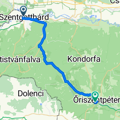
Szentgotthárd - Őriszentpéter
Cycling route in Szentgotthárd, Vas County, Hungary
- 21.6 km
- Distance
- 239 m
- Ascent
- 230 m
- Descent

Őrségi kör 2.
Cycling route in Szentgotthárd, Vas County, Hungary
- 72.7 km
- Distance
- 315 m
- Ascent
- 318 m
- Descent

ŐKVT 1. nap NEW
Cycling route in Szentgotthárd, Vas County, Hungary
- 42.2 km
- Distance
- 410 m
- Ascent
- 387 m
- Descent

Apátistvánfalva - Őriszentpéter (22 km)
Cycling route in Szentgotthárd, Vas County, Hungary
- 22.3 km
- Distance
- 217 m
- Ascent
- 315 m
- Descent

Széll Kálmán tér 15., Szentgotthárd nach Égésszer 35., Őriszentpéter
Cycling route in Szentgotthárd, Vas County, Hungary
- 21.6 km
- Distance
- 241 m
- Ascent
- 234 m
- Descent

Hodoš, Hodoš to 7455 Mellékút-es Mellékút, Őriszentpéter
Cycling route in Szentgotthárd, Vas County, Hungary
- 11.8 km
- Distance
- 126 m
- Ascent
- 182 m
- Descent

Őkvt 2018. 3. nap
Cycling route in Szentgotthárd, Vas County, Hungary
- 29.6 km
- Distance
- 269 m
- Ascent
- 266 m
- Descent
Discover more routes
 PaNaNet túra 2. nap
- Distance
- 32.5 km
- Ascent
- 272 m
- Descent
- 251 m
- Location
- Szentgotthárd, Vas County, Hungary
 Szentgotthárd - Őriszentpéter
- Distance
- 21.6 km
- Ascent
- 239 m
- Descent
- 230 m
- Location
- Szentgotthárd, Vas County, Hungary
 Őrségi kör 2.
- Distance
- 72.7 km
- Ascent
- 315 m
- Descent
- 318 m
- Location
- Szentgotthárd, Vas County, Hungary
 ŐKVT 1. nap NEW
- Distance
- 42.2 km
- Ascent
- 410 m
- Descent
- 387 m
- Location
- Szentgotthárd, Vas County, Hungary
 Apátistvánfalva - Őriszentpéter (22 km)
- Distance
- 22.3 km
- Ascent
- 217 m
- Descent
- 315 m
- Location
- Szentgotthárd, Vas County, Hungary
 Széll Kálmán tér 15., Szentgotthárd nach Égésszer 35., Őriszentpéter
- Distance
- 21.6 km
- Ascent
- 241 m
- Descent
- 234 m
- Location
- Szentgotthárd, Vas County, Hungary
 Hodoš, Hodoš to 7455 Mellékút-es Mellékút, Őriszentpéter
- Distance
- 11.8 km
- Ascent
- 126 m
- Descent
- 182 m
- Location
- Szentgotthárd, Vas County, Hungary
 Őkvt 2018. 3. nap
- Distance
- 29.6 km
- Ascent
- 269 m
- Descent
- 266 m
- Location
- Szentgotthárd, Vas County, Hungary
Routes from Szentgotthárd
Cycling day trip from
Szentgotthárd to Körmend
Routes to Zalalövő
Cycling day trip from
Zalaegerszeg to Zalalövő