
Cycling day trip from Nižná to Liptovský Mikuláš
Customize your own route based on our template or discover how our community prefers to cycle from Nižná to Liptovský Mikuláš.
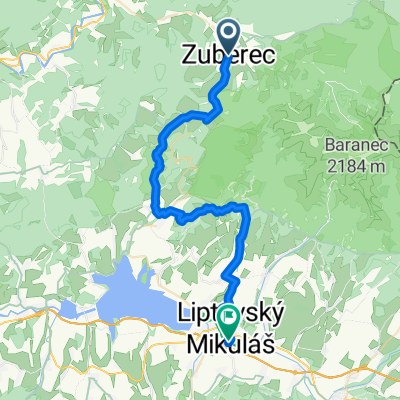
Route template
Nižná to Liptovský Mikuláš
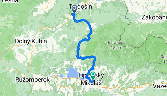
- 3 h 54 min
- Duration
- 53.3 km
- Distance
- 1,293 m
- Ascent
- 1,274 m
- Descent
- 13.6 km/h
- Avg. speed
- 951 m
- Max. altitude
Here’s a scenic cycling adventure through the heart of Slovakia! Your journey starts in Nižná, a lovely village nestled in the Orava region, known for its peaceful atmosphere and charming folk architecture. From here, you’ll pedal south for just over 53 km, weaving through rolling hills and lush valleys as you make your way toward Liptovský Mikuláš—a bustling town famous for its culture, outdoor activities, and proximity to the beautiful Liptovska Mara reservoir.
The route has its fair share of ups and downs, with a total ascent of nearly 1,300 meters, so be ready for some climbs (and rewarding descents!). You’ll mostly stick to paved roads and quiet country tracks, enjoying a good mix of serene paths and the occasional lively road section. As you ride, keep an eye out for panoramic views of the Western Tatras and traditional Slovak villages. Once you arrive in Liptovský Mikuláš, treat yourself to a stroll along the Váh river or relax at one of the town’s cozy cafés—you’ve earned it!
Community
Top users in this region


From our community
The best bike routes from Nižná to Liptovský Mikuláš

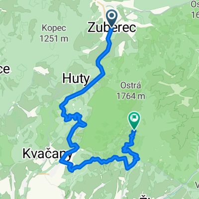
Zuberec- Kvač.dolina- Dlhá Lúka / rozhľadňa
Cycling route in Nižná, Žilina Region, Slovakia
- 17.2 km
- Distance
- 747 m
- Ascent
- 827 m
- Descent

Zuberec-Huty- Kvačany- Lipt.Anna- Havránok
Cycling route in Nižná, Žilina Region, Slovakia
- 29.2 km
- Distance
- 943 m
- Ascent
- 1,134 m
- Descent

Okolo Tatier z Nižnej do L.Mikulášu
Cycling route in Nižná, Žilina Region, Slovakia
- 162.7 km
- Distance
- 1,420 m
- Ascent
- 1,408 m
- Descent

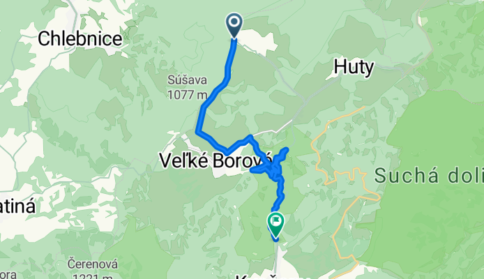
Kvcianska Dolina
Cycling route in Nižná, Žilina Region, Slovakia
- 12.4 km
- Distance
- 190 m
- Ascent
- 541 m
- Descent

Zuberec - Bobr. Vápenica - Ch.pod Náružím
Cycling route in Nižná, Žilina Region, Slovakia
- 33.1 km
- Distance
- 1,390 m
- Ascent
- 744 m
- Descent

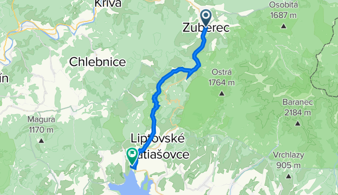
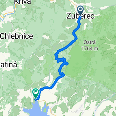
Zuberec - Brnice / Liptovská Mara 2
Cycling route in Nižná, Žilina Region, Slovakia
- 24.5 km
- Distance
- 425 m
- Ascent
- 620 m
- Descent

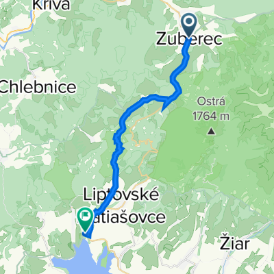
Zuberec-Lipt. Matiašovce - Lipt. Mara - Lipt. Mikuláš
Cycling route in Nižná, Žilina Region, Slovakia
- 34.9 km
- Distance
- 503 m
- Ascent
- 688 m
- Descent

Zuberec - Kvačany - Bobr.Vápenica - Bobrovec - Lipt. Mikuláš
Cycling route in Nižná, Žilina Region, Slovakia
- 36.6 km
- Distance
- 680 m
- Ascent
- 866 m
- Descent

Malé Borové - Bobrovník
Cycling route in Nižná, Žilina Region, Slovakia
- 18.9 km
- Distance
- 448 m
- Ascent
- 784 m
- Descent

Zuberec-Kvačany- Bobrovec- L.Mikuláš
Cycling route in Nižná, Žilina Region, Slovakia
- 34.9 km
- Distance
- 1,209 m
- Ascent
- 1,391 m
- Descent
Kvacianska 2
Cycling route in Nižná, Žilina Region, Slovakia
- 12.1 km
- Distance
- 248 m
- Ascent
- 575 m
- Descent
Zuberec do Liptovská Sielnica
Cycling route in Nižná, Žilina Region, Slovakia
- 19.9 km
- Distance
- 623 m
- Ascent
- 821 m
- Descent
Discover more routes
 Zuberec - Bobr. Vápenica - Ch.pod Náružím
- Distance
- 33.1 km
- Ascent
- 1,390 m
- Descent
- 744 m
- Location
- Nižná, Žilina Region, Slovakia
 Zuberec - Brnice / Liptovská Mara 2
- Distance
- 24.5 km
- Ascent
- 425 m
- Descent
- 620 m
- Location
- Nižná, Žilina Region, Slovakia
 Zuberec-Lipt. Matiašovce - Lipt. Mara - Lipt. Mikuláš
- Distance
- 34.9 km
- Ascent
- 503 m
- Descent
- 688 m
- Location
- Nižná, Žilina Region, Slovakia
 Zuberec - Kvačany - Bobr.Vápenica - Bobrovec - Lipt. Mikuláš
- Distance
- 36.6 km
- Ascent
- 680 m
- Descent
- 866 m
- Location
- Nižná, Žilina Region, Slovakia
 Malé Borové - Bobrovník
- Distance
- 18.9 km
- Ascent
- 448 m
- Descent
- 784 m
- Location
- Nižná, Žilina Region, Slovakia
 Zuberec-Kvačany- Bobrovec- L.Mikuláš
- Distance
- 34.9 km
- Ascent
- 1,209 m
- Descent
- 1,391 m
- Location
- Nižná, Žilina Region, Slovakia
 Kvacianska 2
- Distance
- 12.1 km
- Ascent
- 248 m
- Descent
- 575 m
- Location
- Nižná, Žilina Region, Slovakia
 Zuberec do Liptovská Sielnica
- Distance
- 19.9 km
- Ascent
- 623 m
- Descent
- 821 m
- Location
- Nižná, Žilina Region, Slovakia
Routes from Nižná
Quick ride by bicycle from
Nižná to Trstená
Routes to Liptovský Mikuláš
Cycling day trip from
Ružomberok to Liptovský Mikuláš
Cycling day trip from
Zakopane to Liptovský Mikuláš