
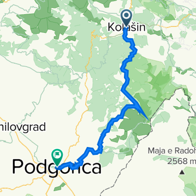
Route template
Kolašin to Podgorica

- 8 h 12 min
- Duration
- 111.6 km
- Distance
- 3,964 m
- Ascent
- 4,853 m
- Descent
- 13.6 km/h
- Avg. speed
- 1,506 m
- Max. altitude
Ready for an adventure? This cycling route takes you from the mountain town of Kolašin down to the Montenegrin capital, Podgorica—a journey of just over 111 km through wild landscapes and remote valleys.
You’ll start in Kolašin, known for its fresh mountain air and lush forests (it’s a great base for exploring Biogradska Gora National Park). The route is packed with elevation changes—nearly 4000 meters of climbing and almost 5000 meters of descending! Max elevation gets above 1500 meters, so you’ll definitely earn those views.
Most of your ride will be on quiet roads and unpaved tracks, so a gravel or mountain bike is a smart choice. There’s barely any busy traffic, letting you really soak in the peacefulness of Montenegro’s heartland. Don’t expect smooth tarmac everywhere—a lot of the way is missing pavement, but that’s half the charm.
Arriving in Podgorica, you’ll swap mountain vistas for the lively riverfront cafes of Montenegro’s biggest city. Bring plenty of snacks, a sense of adventure, and get ready for one seriously memorable ride!
Community
Top users in this region


From our community
The best bike routes from Kolašin to Podgorica

ASL09-010-prijezd do Podgorice
Cycling route in Kolašin, Opština Kolašin, Montenegro
- 58.9 km
- Distance
- 581 m
- Ascent
- 1,441 m
- Descent

4. etapa - KOMOVI (variant 2): Mateševo - Veruša - Bezjovo - Podgorica
Cycling route in Kolašin, Opština Kolašin, Montenegro
- 73.1 km
- Distance
- 712 m
- Ascent
- 1,657 m
- Descent

5. Veruša
Cycling route in Kolašin, Opština Kolašin, Montenegro
- 64.1 km
- Distance
- 894 m
- Ascent
- 2,056 m
- Descent

MONTENEGRO - TAPPA 3 - 23/08/2015
Cycling route in Kolašin, Opština Kolašin, Montenegro
- 82.7 km
- Distance
- 941 m
- Ascent
- 1,843 m
- Descent

Katun Goles - Dodosi
Cycling route in Kolašin, Opština Kolašin, Montenegro
- 114.2 km
- Distance
- 742 m
- Ascent
- 2,384 m
- Descent

Kolasin - Podgorica
Cycling route in Kolašin, Opština Kolašin, Montenegro
- 83.4 km
- Distance
- 973 m
- Ascent
- 1,903 m
- Descent

11a Kolasin - Podgorica
Cycling route in Kolašin, Opština Kolašin, Montenegro
- 71.1 km
- Distance
- 643 m
- Ascent
- 1,539 m
- Descent

Kolasin - Podgorica
Cycling route in Kolašin, Opština Kolašin, Montenegro
- 82.9 km
- Distance
- 817 m
- Ascent
- 1,728 m
- Descent

Montenegro : Kolasin - Bioce
Cycling route in Kolašin, Opština Kolašin, Montenegro
- 62 km
- Distance
- 601 m
- Ascent
- 1,492 m
- Descent

2022 Day 1
Cycling route in Kolašin, Opština Kolašin, Montenegro
- 72 km
- Distance
- 2,217 m
- Ascent
- 3,119 m
- Descent

Kolašin - Bioče real
Cycling route in Kolašin, Opština Kolašin, Montenegro
- 61 km
- Distance
- 658 m
- Ascent
- 1,528 m
- Descent

Dag 6 Matesovo - Podgorica
Cycling route in Kolašin, Opština Kolašin, Montenegro
- 80.7 km
- Distance
- 1,218 m
- Ascent
- 2,160 m
- Descent
Discover more routes
 Katun Goles - Dodosi
- Distance
- 114.2 km
- Ascent
- 742 m
- Descent
- 2,384 m
- Location
- Kolašin, Opština Kolašin, Montenegro
 Kolasin - Podgorica
- Distance
- 83.4 km
- Ascent
- 973 m
- Descent
- 1,903 m
- Location
- Kolašin, Opština Kolašin, Montenegro
 11a Kolasin - Podgorica
- Distance
- 71.1 km
- Ascent
- 643 m
- Descent
- 1,539 m
- Location
- Kolašin, Opština Kolašin, Montenegro
 Kolasin - Podgorica
- Distance
- 82.9 km
- Ascent
- 817 m
- Descent
- 1,728 m
- Location
- Kolašin, Opština Kolašin, Montenegro
 Montenegro : Kolasin - Bioce
- Distance
- 62 km
- Ascent
- 601 m
- Descent
- 1,492 m
- Location
- Kolašin, Opština Kolašin, Montenegro
 2022 Day 1
- Distance
- 72 km
- Ascent
- 2,217 m
- Descent
- 3,119 m
- Location
- Kolašin, Opština Kolašin, Montenegro
 Kolašin - Bioče real
- Distance
- 61 km
- Ascent
- 658 m
- Descent
- 1,528 m
- Location
- Kolašin, Opština Kolašin, Montenegro
 Dag 6 Matesovo - Podgorica
- Distance
- 80.7 km
- Ascent
- 1,218 m
- Descent
- 2,160 m
- Location
- Kolašin, Opština Kolašin, Montenegro
Routes to Podgorica
Cycling day trip from
Kotor to Podgorica