
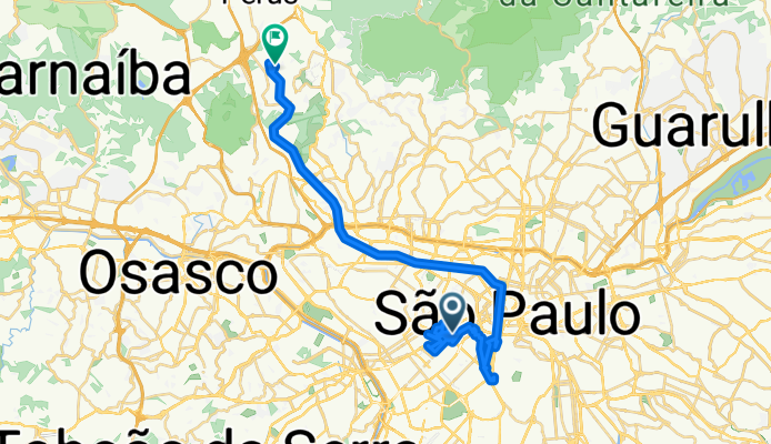
Route template
São Paulo to Caieiras

- 2 h 49 min
- Duration
- 44.2 km
- Distance
- 1,053 m
- Ascent
- 1,032 m
- Descent
- 15.7 km/h
- Avg. speed
- 883 m
- Max. altitude
Here’s a fun route if you’re looking to cycle out of Brazil’s bustling metropolis and experience something greener. You'll set off from São Paulo, the country’s largest city and a powerhouse of culture, coffee, and creative energy. Your destination is Caieiras, known as the "City of the Pines," nestled in the Serra da Cantareira foothills.
The ride itself is roughly 44 km, and with over 1,000 meters of climbing, it’s a solid workout—especially as you wind your way past the edge of São Paulo and into more hilly, forested terrain. You’ll spend most of the ride on quieter roads, with just brief encounters with busier sections, making it a pleasant shake-up from city traffic.
Expect a mix of mostly paved and asphalt surfaces, but note that a significant chunk of the route info is missing—so stay alert for unexpected patches (an adventure in itself!). The final kilometers take you up into fresher air and pine-dotted hillsides, rewarding your effort at Caieiras—a great spot to refuel before heading back or hopping on a train. Happy riding!
Community
Top users in this region


From our community
The best bike routes from São Paulo to Caieiras

Terminal Vila Nova Cachoeirinha - Parque do Canivete Damasceno
Cycling route in São Paulo, São Paulo, Brazil
- 6.5 km
- Distance
- 111 m
- Ascent
- 89 m
- Descent

Rota Sé-Velhão
Cycling route in São Paulo, São Paulo, Brazil
- 21.5 km
- Distance
- 462 m
- Ascent
- 211 m
- Descent


DBM Cat02 - Caieiras - Jd São Paulo
Cycling route in São Paulo, São Paulo, Brazil
- 31.4 km
- Distance
- 848 m
- Ascent
- 854 m
- Descent

Treino na Av Sta Ines
Cycling route in São Paulo, São Paulo, Brazil
- 12.9 km
- Distance
- 448 m
- Ascent
- 127 m
- Descent

De Avenida Paulista 1802 a Alamedas das Seringueiras 662
Cycling route in São Paulo, São Paulo, Brazil
- 24 km
- Distance
- 562 m
- Ascent
- 340 m
- Descent

Rua Doutor José Estefano, 236, São Paulo a Perus, São Paulo
Cycling route in São Paulo, São Paulo, Brazil
- 37 km
- Distance
- 621 m
- Ascent
- 540 m
- Descent

De Rua Bela Cintra a Rua Akio Morita
Cycling route in São Paulo, São Paulo, Brazil
- 45.7 km
- Distance
- 739 m
- Ascent
- 748 m
- Descent

De Rua Clélia 18 a Rua Rodolfo Pereira Lima 185
Cycling route in São Paulo, São Paulo, Brazil
- 12.3 km
- Distance
- 189 m
- Ascent
- 78 m
- Descent

Sesc pompéia - Jaraguá
Cycling route in São Paulo, São Paulo, Brazil
- 13.2 km
- Distance
- 189 m
- Ascent
- 93 m
- Descent
Discover more routes
 DBM Cat02 - Caieiras - Jd São Paulo
- Distance
- 31.4 km
- Ascent
- 848 m
- Descent
- 854 m
- Location
- São Paulo, São Paulo, Brazil
 Treino na Av Sta Ines
- Distance
- 12.9 km
- Ascent
- 448 m
- Descent
- 127 m
- Location
- São Paulo, São Paulo, Brazil
 De Avenida Paulista 1802 a Alamedas das Seringueiras 662
- Distance
- 24 km
- Ascent
- 562 m
- Descent
- 340 m
- Location
- São Paulo, São Paulo, Brazil
 Rua Doutor José Estefano, 236, São Paulo a Perus, São Paulo
- Distance
- 37 km
- Ascent
- 621 m
- Descent
- 540 m
- Location
- São Paulo, São Paulo, Brazil
 Lapa - Jaraguá
- Distance
- 11.8 km
- Ascent
- 182 m
- Descent
- 78 m
- Location
- São Paulo, São Paulo, Brazil
 De Rua Bela Cintra a Rua Akio Morita
- Distance
- 45.7 km
- Ascent
- 739 m
- Descent
- 748 m
- Location
- São Paulo, São Paulo, Brazil
 De Rua Clélia 18 a Rua Rodolfo Pereira Lima 185
- Distance
- 12.3 km
- Ascent
- 189 m
- Descent
- 78 m
- Location
- São Paulo, São Paulo, Brazil
 Sesc pompéia - Jaraguá
- Distance
- 13.2 km
- Ascent
- 189 m
- Descent
- 93 m
- Location
- São Paulo, São Paulo, Brazil
Routes from São Paulo
Cycling day trip from
São Paulo to Taboão da Serra
Cycling day trip from
São Paulo to Osasco