
By bicycle from Quito to Tutamandahostel
Customize your own route based on our template or discover how our community prefers to cycle from Quito to Tutamandahostel.
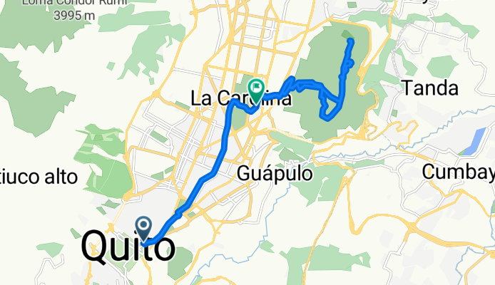
Route template
Quito to Tutamandahostel

- 24 min
- Duration
- 6.9 km
- Distance
- 101 m
- Ascent
- 157 m
- Descent
- 17.3 km/h
- Avg. speed
- 2,904 m
- Max. altitude
This relaxed cycling route takes you from the vibrant heart of Quito to Tutamandahostel, a cool spot for travelers in the city. Starting in Quito, which (fun fact!) is the world’s second-highest capital city, you’ll ride through its lively streets—mostly on quiet roads, making it a chill and safe trip. The journey is just under 7 km, with some enjoyable ups and downs: expect about 100m of climbing with more downhill, so you'll get a bit of a workout without getting too sweaty.
You’ll cruise through local neighborhoods, passing a patchwork of Ecuadorian daily life and colonial-era scenery. The roads are smooth asphalt and well-paved for the most part, perfect for urban cycling. As you roll into your destination—the welcoming Tutamandahostel—you can look forward to a comfy base to rest up, right in the middle of Quito’s action-ready for more city adventures!
Community
Top users in this region


From our community
The best bike routes from Quito to Tutamandahostel
Esmeraldas, Quito a Avenida República de El Salvador, Quito
Cycling route in Quito, Pichincha, Ecuador
- 18.6 km
- Distance
- 1,400 m
- Ascent
- 1,446 m
- Descent


Mena 2 - Ministerio
Cycling route in Quito, Pichincha, Ecuador
- 12.4 km
- Distance
- 181 m
- Ascent
- 316 m
- Descent
Avenida Rumichaca, Quito a Quito
Cycling route in Quito, Pichincha, Ecuador
- 28.5 km
- Distance
- 193 m
- Ascent
- 292 m
- Descent

RUTA EMBICIADA GRATUITA AL TELEFERICO
Cycling route in Quito, Pichincha, Ecuador
- 16.2 km
- Distance
- 1,407 m
- Ascent
- 348 m
- Descent

De S32G Y OE12-P, Quito a Isla Isabela 44-27, Quito
Cycling route in Quito, Pichincha, Ecuador
- 20.6 km
- Distance
- 112 m
- Ascent
- 338 m
- Descent

Chimbacalle-Cumbaya-Puembo-Cumbaya
Cycling route in Quito, Pichincha, Ecuador
- 52.6 km
- Distance
- 709 m
- Ascent
- 1,171 m
- Descent

Pasteurizadora Quito - Nuevo Aeropuerto Tababela
Cycling route in Quito, Pichincha, Ecuador
- 51.7 km
- Distance
- 656 m
- Ascent
- 1,108 m
- Descent

El Cinto-Torouco-Cruz Loma CLONED FROM ROUTE 1673064
Cycling route in Quito, Pichincha, Ecuador
- 19.4 km
- Distance
- 1,032 m
- Ascent
- 349 m
- Descent


CHAQUIÑAN, QUITO - CUMBAYA.
Cycling route in Quito, Pichincha, Ecuador
- 18.1 km
- Distance
- 238 m
- Ascent
- 694 m
- Descent
Discover more routes
 Avenida Rumichaca, Quito a Quito
- Distance
- 28.5 km
- Ascent
- 193 m
- Descent
- 292 m
- Location
- Quito, Pichincha, Ecuador
 RUTA EMBICIADA GRATUITA AL TELEFERICO
- Distance
- 16.2 km
- Ascent
- 1,407 m
- Descent
- 348 m
- Location
- Quito, Pichincha, Ecuador
 De S32G Y OE12-P, Quito a Isla Isabela 44-27, Quito
- Distance
- 20.6 km
- Ascent
- 112 m
- Descent
- 338 m
- Location
- Quito, Pichincha, Ecuador
 Chimbacalle-Cumbaya-Puembo-Cumbaya
- Distance
- 52.6 km
- Ascent
- 709 m
- Descent
- 1,171 m
- Location
- Quito, Pichincha, Ecuador
 Pasteurizadora Quito - Nuevo Aeropuerto Tababela
- Distance
- 51.7 km
- Ascent
- 656 m
- Descent
- 1,108 m
- Location
- Quito, Pichincha, Ecuador
 El Cinto-Torouco-Cruz Loma CLONED FROM ROUTE 1673064
- Distance
- 19.4 km
- Ascent
- 1,032 m
- Descent
- 349 m
- Location
- Quito, Pichincha, Ecuador
 EC001
EC001- Distance
- 3,575.9 km
- Ascent
- 7,445 m
- Descent
- 7,596 m
- Location
- Quito, Pichincha, Ecuador
 CHAQUIÑAN, QUITO - CUMBAYA.
- Distance
- 18.1 km
- Ascent
- 238 m
- Descent
- 694 m
- Location
- Quito, Pichincha, Ecuador
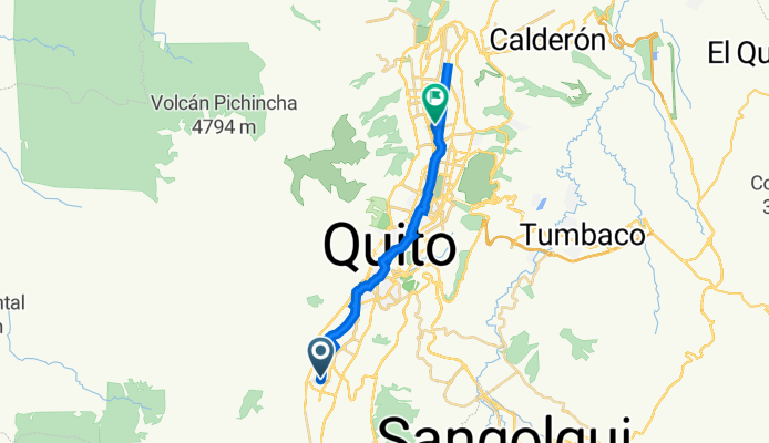
Routes from Quito
Cycling day trip from
Quito to Sangolquí