
Cycling day trip from Puente Alto to Villa Presidente Frei
Customize your own route based on our template or discover how our community prefers to cycle from Puente Alto to Villa Presidente Frei.
Route template
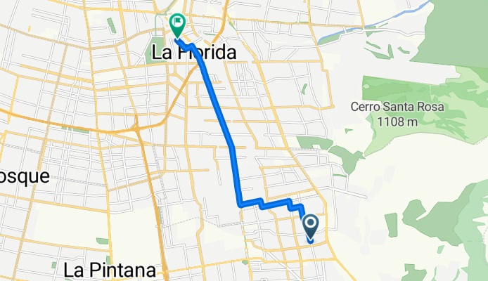
Puente Alto to Villa Presidente Frei

- 1 h 27 min
- Duration
- 25.9 km
- Distance
- 38 m
- Ascent
- 137 m
- Descent
- 17.9 km/h
- Avg. speed
- 700 m
- Max. altitude
Set out from bustling Puente Alto, one of Santiago’s largest and liveliest communes, and head north toward the residential tranquility of Villa Presidente Frei. This 26 km route is mostly flat (with just a gentle 38 meters of ascent and a longer, easy descent), making it friendly for most riders.
You’ll pedal mainly on paved roads—expect a smooth ride—with over 40% of the journey along dedicated cycleways, perfect for zoning out and soaking in the sights. Much of the rest winds through quiet backstreets, with very little time spent on busier roads. Along the way, you’ll witness the transition from urban energy to the leafy neighborhoods closer to your destination.
Villa Presidente Frei is a peaceful spot, known for its parks and community vibe. It’s a great place to catch your breath at the end of your ride. Whether it’s your daily commute or a weekend adventure, this route offers a snapshot of Santiago’s diverse neighborhoods without too many hills to slow you down. Happy cycling!
Community
Top users in this region


From our community
The best bike routes from Puente Alto to Villa Presidente Frei

Alcalde Luis Osorio 652, Puente Alto a Avenida Ricardo Lyon 1458, Providencia
Cycling route in Puente Alto, Santiago Metropolitan, Chile
- 24.3 km
- Distance
- 67 m
- Ascent
- 127 m
- Descent

A Z O T E
Cycling route in Puente Alto, Santiago Metropolitan, Chile
- 27.7 km
- Distance
- 96 m
- Ascent
- 131 m
- Descent
Avenida Gabriela Oriente, Puente Alto a Avenida Vicuña Mackenna Poniente, La Florida
Cycling route in Puente Alto, Santiago Metropolitan, Chile
- 9.9 km
- Distance
- 0 m
- Ascent
- 92 m
- Descent

De San Mauricio 3123, Puente Alto a Pasaje 35 1505, Ñuñoa
Cycling route in Puente Alto, Santiago Metropolitan, Chile
- 14.8 km
- Distance
- 15 m
- Ascent
- 118 m
- Descent

José Miguel Carrera 1256–1390, La Florida a Canal las Perdices, La Florida
Cycling route in Puente Alto, Santiago Metropolitan, Chile
- 5.7 km
- Distance
- 231 m
- Ascent
- 33 m
- Descent

Mariano Sánchez Fontecilla 3701–3729, La Florida a Las Tinajas 6000, La Florida
Cycling route in Puente Alto, Santiago Metropolitan, Chile
- 2 km
- Distance
- 152 m
- Ascent
- 32 m
- Descent

De Lago Condor 1348, Cordillera a Alonso de Ercilla 1270, La Florida
Cycling route in Puente Alto, Santiago Metropolitan, Chile
- 10.9 km
- Distance
- 6 m
- Ascent
- 82 m
- Descent

templo bahai 😊
Cycling route in Puente Alto, Santiago Metropolitan, Chile
- 16.9 km
- Distance
- 384 m
- Ascent
- 87 m
- Descent

panul mirador
Cycling route in Puente Alto, Santiago Metropolitan, Chile
- 0.6 km
- Distance
- 0 m
- Ascent
- 51 m
- Descent

puente alto Vitacura
Cycling route in Puente Alto, Santiago Metropolitan, Chile
- 27.7 km
- Distance
- 546 m
- Ascent
- 510 m
- Descent

Recovered Route
Cycling route in Puente Alto, Santiago Metropolitan, Chile
- 12.2 km
- Distance
- 31 m
- Ascent
- 152 m
- Descent

Ida a Lo Cañas 3636, La Florida
Cycling route in Puente Alto, Santiago Metropolitan, Chile
- 6.4 km
- Distance
- 56 m
- Ascent
- 65 m
- Descent
Discover more routes
 José Miguel Carrera 1256–1390, La Florida a Canal las Perdices, La Florida
- Distance
- 5.7 km
- Ascent
- 231 m
- Descent
- 33 m
- Location
- Puente Alto, Santiago Metropolitan, Chile
 Mariano Sánchez Fontecilla 3701–3729, La Florida a Las Tinajas 6000, La Florida
- Distance
- 2 km
- Ascent
- 152 m
- Descent
- 32 m
- Location
- Puente Alto, Santiago Metropolitan, Chile
 De Lago Condor 1348, Cordillera a Alonso de Ercilla 1270, La Florida
- Distance
- 10.9 km
- Ascent
- 6 m
- Descent
- 82 m
- Location
- Puente Alto, Santiago Metropolitan, Chile
 templo bahai 😊
- Distance
- 16.9 km
- Ascent
- 384 m
- Descent
- 87 m
- Location
- Puente Alto, Santiago Metropolitan, Chile
 panul mirador
- Distance
- 0.6 km
- Ascent
- 0 m
- Descent
- 51 m
- Location
- Puente Alto, Santiago Metropolitan, Chile
 puente alto Vitacura
- Distance
- 27.7 km
- Ascent
- 546 m
- Descent
- 510 m
- Location
- Puente Alto, Santiago Metropolitan, Chile
 Recovered Route
- Distance
- 12.2 km
- Ascent
- 31 m
- Descent
- 152 m
- Location
- Puente Alto, Santiago Metropolitan, Chile
 Ida a Lo Cañas 3636, La Florida
- Distance
- 6.4 km
- Ascent
- 56 m
- Descent
- 65 m
- Location
- Puente Alto, Santiago Metropolitan, Chile
Routes from Puente Alto
Cycling day trip from
Puente Alto to Santiago
Quick ride by bicycle from
Puente Alto to La Pintana
Routes to Villa Presidente Frei
Cycling day trip from
Chicureo to Villa Presidente Frei
Cycling day trip from
La Pintana to Villa Presidente Frei
Quick ride by bicycle from
Santiago to Villa Presidente Frei