
Cycling day trip from Chicureo to Villa Presidente Frei
Customize your own route based on our template or discover how our community prefers to cycle from Chicureo to Villa Presidente Frei.
Route template
Chicureo to Villa Presidente Frei
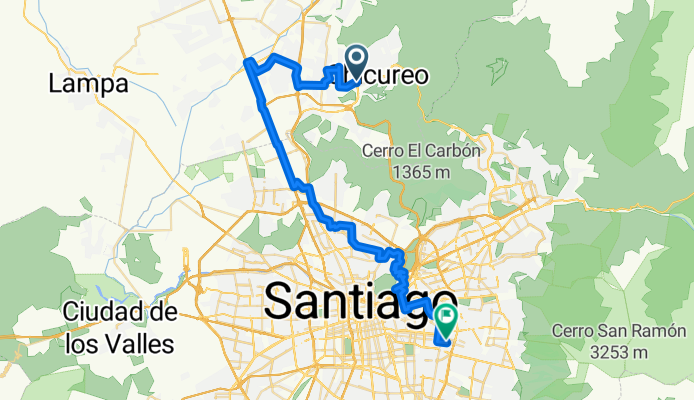
- 3 h 8 min
- Duration
- 54.5 km
- Distance
- 380 m
- Ascent
- 338 m
- Descent
- 17.4 km/h
- Avg. speed
- 698 m
- Max. altitude
This scenic cycling route takes you from the peaceful outskirts of Chicureo, a growing suburban area known for its green spaces and mountain views, all the way to Villa Presidente Frei, a vibrant residential neighborhood in northern Santiago.
The ride covers a nice long stretch—just over 54 kilometers—so it’s perfect if you’re up for a solid day in the saddle. You'll start off surrounded by the rolling hills and gated communities of Chicureo, then head south toward the city, with spectacular views of the Andes on your right. The route is mostly on pavement, with a good balance between cycleways and quieter roads, though you’ll encounter a few busier sections as you approach Santiago.
Along the way, you’ll ride through different neighborhoods and commercial areas, giving you a real feel for the variety of life surrounding Chile’s capital. The final stretch brings you into Villa Presidente Frei, known for its parks and a lively local atmosphere. With some gentle climbs and quick descents, this ride is both enjoyable and a great workout!
Community
Top users in this region


From our community
The best bike routes from Chicureo to Villa Presidente Frei

Huinganal - santuario de la naturaleza CLONED FROM ROUTE 831605
Cycling route in Chicureo, Santiago Metropolitan, Chile
- 22.8 km
- Distance
- 747 m
- Ascent
- 848 m
- Descent

Camino Buenavista 3927, Lo Barnechea a Robles 13301, Lo Barnechea
Cycling route in Chicureo, Santiago Metropolitan, Chile
- 8.6 km
- Distance
- 104 m
- Ascent
- 142 m
- Descent

Pasaje Los Agustinos Sur 1638, Huechuraba a Coyancura 2292, Providencia
Cycling route in Chicureo, Santiago Metropolitan, Chile
- 15.2 km
- Distance
- 137 m
- Ascent
- 13 m
- Descent

Camino Real 4410, Lo Barnechea a Robles 13307, Lo Barnechea
Cycling route in Chicureo, Santiago Metropolitan, Chile
- 7.9 km
- Distance
- 71 m
- Ascent
- 112 m
- Descent

Calbucura 6831, Huechuraba a Nueva Los Leones 7, Providencia
Cycling route in Chicureo, Santiago Metropolitan, Chile
- 17 km
- Distance
- 189 m
- Ascent
- 68 m
- Descent

Recovered Route
Cycling route in Chicureo, Santiago Metropolitan, Chile
- 2.2 km
- Distance
- 69 m
- Ascent
- 150 m
- Descent

De El Quillay 1142, Colina a Avenida Vitacura 4139
Cycling route in Chicureo, Santiago Metropolitan, Chile
- 36.9 km
- Distance
- 257 m
- Ascent
- 202 m
- Descent

De El Quillay 1142, Colina a Avenida Vitacura 4111
Cycling route in Chicureo, Santiago Metropolitan, Chile
- 33.2 km
- Distance
- 232 m
- Ascent
- 175 m
- Descent
Ruta a Avenida Vitacura 4139
Cycling route in Chicureo, Santiago Metropolitan, Chile
- 37 km
- Distance
- 260 m
- Ascent
- 199 m
- Descent

Camino Real, Lo Barnechea a Robles 13307, Lo Barnechea
Cycling route in Chicureo, Santiago Metropolitan, Chile
- 8.6 km
- Distance
- 171 m
- Ascent
- 214 m
- Descent

MTB Clásico, Vitacura a Simón Bolívar 3756, Ñuñoa
Cycling route in Chicureo, Santiago Metropolitan, Chile
- 15.1 km
- Distance
- 31 m
- Ascent
- 603 m
- Descent

Discover more routes
 Calbucura 6831, Huechuraba a Nueva Los Leones 7, Providencia
- Distance
- 17 km
- Ascent
- 189 m
- Descent
- 68 m
- Location
- Chicureo, Santiago Metropolitan, Chile
 Recovered Route
- Distance
- 2.2 km
- Ascent
- 69 m
- Descent
- 150 m
- Location
- Chicureo, Santiago Metropolitan, Chile
 De El Quillay 1142, Colina a Avenida Vitacura 4139
- Distance
- 36.9 km
- Ascent
- 257 m
- Descent
- 202 m
- Location
- Chicureo, Santiago Metropolitan, Chile
 De El Quillay 1142, Colina a Avenida Vitacura 4111
- Distance
- 33.2 km
- Ascent
- 232 m
- Descent
- 175 m
- Location
- Chicureo, Santiago Metropolitan, Chile
 Ruta a Avenida Vitacura 4139
- Distance
- 37 km
- Ascent
- 260 m
- Descent
- 199 m
- Location
- Chicureo, Santiago Metropolitan, Chile
 Camino Real, Lo Barnechea a Robles 13307, Lo Barnechea
- Distance
- 8.6 km
- Ascent
- 171 m
- Descent
- 214 m
- Location
- Chicureo, Santiago Metropolitan, Chile
 MTB Clásico, Vitacura a Simón Bolívar 3756, Ñuñoa
- Distance
- 15.1 km
- Ascent
- 31 m
- Descent
- 603 m
- Location
- Chicureo, Santiago Metropolitan, Chile
 colegio
- Distance
- 7.1 km
- Ascent
- 22 m
- Descent
- 128 m
- Location
- Chicureo, Santiago Metropolitan, Chile
Routes from Chicureo
Cycling day trip from
Chicureo to Lo Prado
Cycling day trip from
Chicureo to Santiago
Routes to Villa Presidente Frei
Cycling day trip from
Puente Alto to Villa Presidente Frei
Cycling day trip from
La Pintana to Villa Presidente Frei
Quick ride by bicycle from
Santiago to Villa Presidente Frei