
Quick ride by bicycle from Falcon Heights to Minneapolis
Customize your own route based on our template or discover how our community prefers to cycle from Falcon Heights to Minneapolis.
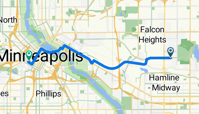
Route template
Falcon Heights to Minneapolis

- 39 min
- Duration
- 11.4 km
- Distance
- 37 m
- Ascent
- 69 m
- Descent
- 17.8 km/h
- Avg. speed
- 289 m
- Max. altitude
This cycling route takes you from Falcon Heights—home to the Minnesota State Fairgrounds and beautiful tree-lined neighborhoods—straight into the heart of Minneapolis, passing through university campuses and lively city streets. It’s about 11.4 km long and mostly flat, with gentle elevation changes, making it beginner-friendly yet satisfying for seasoned cyclists.
Most of your ride will roll along dedicated cycleways and quiet roads, so you can enjoy the scenery without worrying too much about heavy traffic. With more than 90% of the path on paved surfaces (mostly smooth asphalt), you’ll have a comfortable spin the whole way.
As you approach Minneapolis, you’ll notice the skyline growing closer and the energy picking up—maybe stop for coffee or just cruise into the city’s many parks and riverside trails. It’s a straightforward ride with the best of both suburbs and city life. Grab your helmet and enjoy!
Community
Top users in this region


From our community
The best bike routes from Falcon Heights to Minneapolis

Memorial Ride - 10/04/08
Cycling route in Falcon Heights, Minnesota, United States
- 23 km
- Distance
- 116 m
- Ascent
- 157 m
- Descent

B2B00017 - 55104 to 55402
Cycling route in Falcon Heights, Minnesota, United States
- 12.2 km
- Distance
- 125 m
- Ascent
- 155 m
- Descent

B2B00715 55406 > 55402 via W River Pkwy, Midtown Greenway
Cycling route in Falcon Heights, Minnesota, United States
- 9.2 km
- Distance
- 67 m
- Ascent
- 82 m
- Descent

B2B00116 55113>55406 via hoyt, intercampus transitway, river road, and 24th
Cycling route in Falcon Heights, Minnesota, United States
- 9.7 km
- Distance
- 51 m
- Ascent
- 81 m
- Descent
B2B00180 55108>55402viaComo/Transitway/4thSE/Stonearch/2ndAV
Cycling route in Falcon Heights, Minnesota, United States
- 10.8 km
- Distance
- 93 m
- Ascent
- 105 m
- Descent

B2B00346 55108 > 55401 via Hoyt, Transit Way, 5th St, Stone Arch
Cycling route in Falcon Heights, Minnesota, United States
- 12.3 km
- Distance
- 74 m
- Ascent
- 88 m
- Descent

B2B00553 55108>55414 viaLarp/Hamline/Como/Intercampus/4thStSE/Main
Cycling route in Falcon Heights, Minnesota, United States
- 11 km
- Distance
- 24 m
- Ascent
- 55 m
- Descent

B2B00339 55104 > 55415 via Fairview, Marshall, River Road
Cycling route in Falcon Heights, Minnesota, United States
- 11.5 km
- Distance
- 55 m
- Ascent
- 84 m
- Descent

B2B00342 55415>55415 via Como Ave, Transitway, 4th St SE, Stone Arch Bridge
Cycling route in Falcon Heights, Minnesota, United States
- 12.1 km
- Distance
- 84 m
- Ascent
- 88 m
- Descent

Prior Ave N, Saint Paul to 3348–4180 W River Pkwy, Minneapolis
Cycling route in Falcon Heights, Minnesota, United States
- 4.6 km
- Distance
- 19 m
- Ascent
- 48 m
- Descent

B2B00325 55104 > 55415 via Marshall, W River Pkwy
Cycling route in Falcon Heights, Minnesota, United States
- 8.9 km
- Distance
- 45 m
- Ascent
- 80 m
- Descent

B2B00180 55108>55402viaComo/Intercampus/StoneArch/2ndAv
Cycling route in Falcon Heights, Minnesota, United States
- 10.8 km
- Distance
- 93 m
- Ascent
- 105 m
- Descent
Discover more routes
 B2B00180 55108>55402viaComo/Transitway/4thSE/Stonearch/2ndAV
- Distance
- 10.8 km
- Ascent
- 93 m
- Descent
- 105 m
- Location
- Falcon Heights, Minnesota, United States
 B2B00346 55108 > 55401 via Hoyt, Transit Way, 5th St, Stone Arch
- Distance
- 12.3 km
- Ascent
- 74 m
- Descent
- 88 m
- Location
- Falcon Heights, Minnesota, United States
 B2B00553 55108>55414 viaLarp/Hamline/Como/Intercampus/4thStSE/Main
- Distance
- 11 km
- Ascent
- 24 m
- Descent
- 55 m
- Location
- Falcon Heights, Minnesota, United States
 B2B00339 55104 > 55415 via Fairview, Marshall, River Road
- Distance
- 11.5 km
- Ascent
- 55 m
- Descent
- 84 m
- Location
- Falcon Heights, Minnesota, United States
 B2B00342 55415>55415 via Como Ave, Transitway, 4th St SE, Stone Arch Bridge
- Distance
- 12.1 km
- Ascent
- 84 m
- Descent
- 88 m
- Location
- Falcon Heights, Minnesota, United States
 Prior Ave N, Saint Paul to 3348–4180 W River Pkwy, Minneapolis
- Distance
- 4.6 km
- Ascent
- 19 m
- Descent
- 48 m
- Location
- Falcon Heights, Minnesota, United States
 B2B00325 55104 > 55415 via Marshall, W River Pkwy
- Distance
- 8.9 km
- Ascent
- 45 m
- Descent
- 80 m
- Location
- Falcon Heights, Minnesota, United States
 B2B00180 55108>55402viaComo/Intercampus/StoneArch/2ndAv
- Distance
- 10.8 km
- Ascent
- 93 m
- Descent
- 105 m
- Location
- Falcon Heights, Minnesota, United States
Routes to Minneapolis
Cycling day trip from
Richfield to Minneapolis
Cycling day trip from
West Saint Paul to Minneapolis
Quick ride by bicycle from
Saint Louis Park to Minneapolis
Quick ride by bicycle from
Lauderdale to Minneapolis