
Cycling day trip from Saint Louis Park to Burnsville
Customize your own route based on our template or discover how our community prefers to cycle from Saint Louis Park to Burnsville.
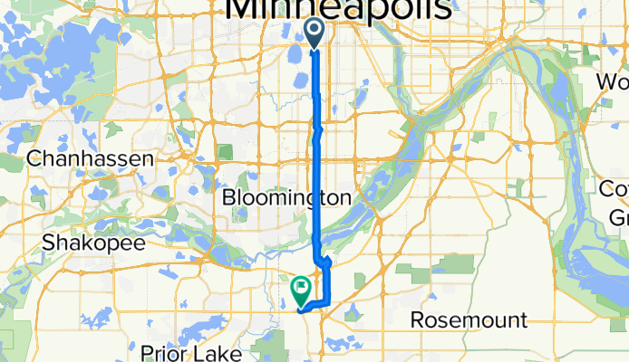
Route template
Saint Louis Park to Burnsville

- 2 h 24 min
- Duration
- 42.9 km
- Distance
- 209 m
- Ascent
- 184 m
- Descent
- 17.9 km/h
- Avg. speed
- 298 m
- Max. altitude
This ride takes you from Saint Louis Park, a bike-friendly suburb just west of Minneapolis, all the way down to Burnsville, which sits south of the river and is known for its parks and trails. Most of your trip sticks to smooth, paved surfaces (almost all asphalt), and about 90% follows dedicated cycleways—perfect for a relaxed cruise without much traffic stress.
You’ll roll past peaceful neighborhoods, slip alongside scenic parks, and cross the Minnesota River valley, catching a bit of elevation (about 209 meters total ascent, but nothing too daunting). Saint Louis Park is famous for its great community feel and proximity to the Chain of Lakes, while Burnsville is a gateway to nature adventures, including the massive Buck Hill ski area—which you might spot as you arrive.
At just under 43 kilometers, this route gives you a solid workout, but the roads are calm and inviting, making it perfect for a long weekend ride. Just remember to bring snacks and water, and enjoy the journey through two of the Twin Cities’ most bike-friendly areas!
Community
Top users in this region


From our community
The best bike routes from Saint Louis Park to Burnsville

3228 Bryant Ave S, Minneapolis to 2032 CR-42 W, Burnsville
Cycling route in Saint Louis Park, Minnesota, United States
- 24.6 km
- Distance
- 192 m
- Ascent
- 154 m
- Descent

3224 Bryant Ave S, Minneapolis to 2032 CR-42 W, Burnsville
Cycling route in Saint Louis Park, Minnesota, United States
- 27.2 km
- Distance
- 207 m
- Ascent
- 171 m
- Descent
3224 Bryant Ave S, Minneapolis to 2032 CR-42 W, Burnsville
Cycling route in Saint Louis Park, Minnesota, United States
- 26.8 km
- Distance
- 207 m
- Ascent
- 167 m
- Descent
3224 Bryant Ave S, Minneapolis to 2030 CR-42 W, Burnsville
Cycling route in Saint Louis Park, Minnesota, United States
- 26.6 km
- Distance
- 190 m
- Ascent
- 152 m
- Descent

3224 Bryant Ave S, Minneapolis to 2032 CR-42 W, Burnsville
Cycling route in Saint Louis Park, Minnesota, United States
- 25.1 km
- Distance
- 193 m
- Ascent
- 145 m
- Descent

3232 Bryant Ave S, Minneapolis to 2030 CR-42 W, Burnsville
Cycling route in Saint Louis Park, Minnesota, United States
- 26.7 km
- Distance
- 199 m
- Ascent
- 163 m
- Descent

3220 Bryant Ave S, Minneapolis to 2032 CR-42 W, Burnsville
Cycling route in Saint Louis Park, Minnesota, United States
- 26.5 km
- Distance
- 193 m
- Ascent
- 152 m
- Descent

3228 Bryant Ave S, Minneapolis to 2032 CR-42 W, Burnsville
Cycling route in Saint Louis Park, Minnesota, United States
- 27 km
- Distance
- 229 m
- Ascent
- 195 m
- Descent

W 33rd St, Minneapolis to 2030 CR-42 W, Burnsville
Cycling route in Saint Louis Park, Minnesota, United States
- 27.1 km
- Distance
- 199 m
- Ascent
- 162 m
- Descent

3238 Bryant Ave S, Minneapolis to 2030 CR-42 W, Burnsville
Cycling route in Saint Louis Park, Minnesota, United States
- 26.5 km
- Distance
- 193 m
- Ascent
- 145 m
- Descent

3224 Bryant Ave S, Minneapolis to 2032 CR-42 W, Burnsville
Cycling route in Saint Louis Park, Minnesota, United States
- 30.8 km
- Distance
- 204 m
- Ascent
- 165 m
- Descent

44.944° N -93.291° W to 2032 CR-42 W, Burnsville
Cycling route in Saint Louis Park, Minnesota, United States
- 27 km
- Distance
- 212 m
- Ascent
- 177 m
- Descent
Discover more routes
 3224 Bryant Ave S, Minneapolis to 2032 CR-42 W, Burnsville
- Distance
- 25.1 km
- Ascent
- 193 m
- Descent
- 145 m
- Location
- Saint Louis Park, Minnesota, United States
 3232 Bryant Ave S, Minneapolis to 2030 CR-42 W, Burnsville
- Distance
- 26.7 km
- Ascent
- 199 m
- Descent
- 163 m
- Location
- Saint Louis Park, Minnesota, United States
 3220 Bryant Ave S, Minneapolis to 2032 CR-42 W, Burnsville
- Distance
- 26.5 km
- Ascent
- 193 m
- Descent
- 152 m
- Location
- Saint Louis Park, Minnesota, United States
 3228 Bryant Ave S, Minneapolis to 2032 CR-42 W, Burnsville
- Distance
- 27 km
- Ascent
- 229 m
- Descent
- 195 m
- Location
- Saint Louis Park, Minnesota, United States
 W 33rd St, Minneapolis to 2030 CR-42 W, Burnsville
- Distance
- 27.1 km
- Ascent
- 199 m
- Descent
- 162 m
- Location
- Saint Louis Park, Minnesota, United States
 3238 Bryant Ave S, Minneapolis to 2030 CR-42 W, Burnsville
- Distance
- 26.5 km
- Ascent
- 193 m
- Descent
- 145 m
- Location
- Saint Louis Park, Minnesota, United States
 3224 Bryant Ave S, Minneapolis to 2032 CR-42 W, Burnsville
- Distance
- 30.8 km
- Ascent
- 204 m
- Descent
- 165 m
- Location
- Saint Louis Park, Minnesota, United States
 44.944° N -93.291° W to 2032 CR-42 W, Burnsville
- Distance
- 27 km
- Ascent
- 212 m
- Descent
- 177 m
- Location
- Saint Louis Park, Minnesota, United States
Routes from Saint Louis Park
By bicycle from
Saint Louis Park to Minneapolis